METAR & TAF S66
S66 does not publish a METAR.
Showing the nearest reporting station: KEUL (CALDWELL EXEC) · 12.5 NM away. Conditions at S66 may differ.
METAR · KEUL
Observed 16:56Z
KEUL 271656Z AUTO 28007KT 4SM HZ CLR 25/07 A3002 RMK AO2 SLP145 T02500072 $
- Wind
- 280° @ 7 kt
- Visibility
- 4 SM
- Temp / Dew
- 25°C / 7°C
- Altimeter
- 30.02 inHg
- Clouds
- CLR
- Density alt
- 3,829 ft
- Ceiling
- Unlimited
- Rules
- MVFR
Airport info & contacts
Manager on record, flight service, ARTCC, attendance schedule and pattern altitude — published by the FAA and refreshed every 28 days.
Location
- From city
- 0 NM SE
- VFR sectional
- SALT LAKE CITY
- ARTCC
- ZLC · SALT LAKE CITY
- NOTAM facility
- BOI (NOTAM-D)
Airport manager
- Name
- JACOB HEYER
- Phone
- 208-972-2160
- Address
- 31 W WYOMING AVE, HOMEDALE ID 83628
Flight service · Hours
- FSS BOI
- BOISE1-800-WX-BRIEF
- Attendance
- Unattended
Frequencies
Tap any row to copy the frequency to your clipboard.
Runways & pattern
Full pagePattern entry · RWY 31
LEFT TRAFFICRunway end performance
| End | TORA | TODA | ASDA | LDA | VGSI | Approach lights | Obstruction |
|---|---|---|---|---|---|---|---|
| 13 | — | — | — | — | — | — | 60', tree, 760' from thr, 0' R of cntrln, slope 9 |
| 31 | — | — | — | — | — | — | 95', trees, 310' from thr, 140' R of cntrln, slope 1 |
Declared distances in feet. TORA = takeoff run available, TODA = takeoff distance, ASDA = accelerate-stop, LDA = landing distance.
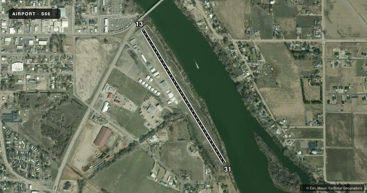
Airport sketch
Runways drawn to scale from FAA survey coordinates, rendered over satellite imagery. Not for navigation.
Approaches & charts
Services on the field
Fuel grades, oxygen, maintenance, ramp storage and lighting — as declared to the FAA by the airport operator.
Fuel & services
- Fuel
- Not available
- Oxygen (bottled)
- Not available
- Oxygen (bulk)
- Not available
- Airframe repair
- Minor
- Other services
- SALES
Ramp & ground
- Transient storage
- Tie-down
- Landing fee
- No fee published
- Customs
- Not available
- Wind indicator
- Yes
- Segmented circle
- No
Fuel & FBOs
Cheapest 100LL and Jet A on the field and nearby. Always confirm with the FBO before taxi.
Airport notes
Surface conditions, obstructions, local procedures, lighting outages and other notes published with each FAA cycle.
General notes
- NO TELEPHONE AVBL AT ARPT.
- FOR CD CTC BIG SKY APCH AT 208-364-5860/5861.
Approach & departure obstructions
- 13+4 FT FENCE 20 FT FM RWY 31 END; +12 FT ROAD AT 25 FT ON CNTRLN; +21 FT BURM/HWY95 AT 140 FT FM END OF PVMT/RWY 13 ON CNTRLN; .
- 31+4 FT FENCE AT 70 FT ON CNTRLN; +15 FT BRUSH IN FIRST 200 FT OF DTHR AT 50 FT R.
- 13RWY 13 +21 FT HWY, 420 FT ON CNTRLN, 20:1 FM THE DTHR BAR.
- 13NMRS ADDNL OBSTN ON APCH TO RWY 13 (TREES, P-LINE AT 800 FT OUT, AND RD/HWY SIGNS).
Other notes
- ESTABD PRIOR TO 15 MAY 1959.
VFR map & nearby airports
VFR sectional. Tap any ICAO chip to open that airport.
Key facts · S66
Answer card- ICAO
- S66
- Name
- HOMEDALE MUNI
- Location
- HOMEDALE, IDAHO
- Elevation
- 2,220 ft MSL
- Traffic pattern altitude
- 3,220 ft MSL (1,000 AGL)
- Control tower
- Non-towered (use CTAF)
- Total runways
- 1
- Longest runway
- 13/31 · 2,901 ft
- Published ILS approaches
- 0
- Published frequencies
- 1
- Magnetic variation
- 17°
- Current flight rules
- MVFR
- Current wind
- 280° at 7 kt
- Favored runway now
- RWY 31
Homedale Muni sits in Homedale, Idaho. Field elevation is 2,220 ft MSL. The airport has one runway, 13/31, which is 2,901 ft long and asphalt. There is no control tower. CTAF is 122.9. No ILS approaches are published here.
Pattern altitude is not published. Use the standard 1,000 ft AGL pattern unless local procedures or the current Chart Supplement say otherwise. That puts the traffic pattern at 3,220 ft MSL based on the field elevation. Verify before you go. The airport is uncontrolled, so expect self-announced traffic on CTAF. Plan your spacing early.
There are no on-field FBOs listed in the facts. Fuel and services need to be confirmed with the airport operator or by calling the field directly before arrival. Published remarks call out several obstructions near both runway ends. Runway 13 has fences, a road, berms and other obstacles close in on approach. Runway 31 has a fence and brush near the displaced threshold area. If you are new to the field, study the current Chart Supplement and brief the approach carefully. Clearance delivery for IFR is handled through Big Sky Approach per the published remarks.