METAR & TAF KONO
Current METAR
Observed 16:53Z
KONO 271653Z AUTO 25006KT 4SM HZ OVC020 26/09 A3002 RMK AO2 SLP148 T02610094
- Wind
- 250° @ 6 kt
- Visibility
- 4 SM
- Temp / Dew
- 26°C / 9°C
- Altimeter
- 30.02 inHg
- Clouds
- OVC
- Density alt
- 3,916 ft
- Ceiling
- 2,000 ft AGL
- Rules
- MVFR
Airport info & contacts
Manager on record, flight service, ARTCC, attendance schedule and pattern altitude — published by the FAA and refreshed every 28 days.
Location
- From city
- 3 NM W
- VFR sectional
- KLAMATH FALLS
- ARTCC
- ZLC · SALT LAKE CITY
- NOTAM facility
- ONO (NOTAM-D)
Airport manager
- Name
- ANDY WOOD
- Phone
- 541-709-7651
- Address
- 581 SW 33RD ST., ONTARIO OR 97914
Flight service · Hours
- FSS MMV
- MC MINNVILLE1-800-WX-BRIEF
- Attendance
- NOV-MAR · M-F · 0900-1500
- APR-OCT · 0800-1700
Frequencies
Tap any row to copy the frequency to your clipboard.
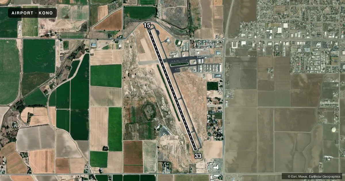
Runways & pattern
Full pagePattern entry · RWY 33
LEFT TRAFFICRunway end performance
| End | TORA | TODA | ASDA | LDA | VGSI | Approach lights | Obstruction |
|---|---|---|---|---|---|---|---|
| 15 | — | — | — | — | PAPI 2-box left(3°) | — | 10', road, 380' from thr, slope 18 |
| 33 | — | — | — | — | PAPI 2-box left(3°) | — | — |
Declared distances in feet. TORA = takeoff run available, TODA = takeoff distance, ASDA = accelerate-stop, LDA = landing distance.
Airport sketch
Runways drawn to scale from FAA survey coordinates, rendered over satellite imagery. Not for navigation.
Approaches & charts
Services on the field
Fuel grades, oxygen, maintenance, ramp storage and lighting — as declared to the FAA by the airport operator.
Fuel & services
- Fuel
- 100LLA
- Oxygen (bottled)
- Not available
- Airframe repair
- Major
- Power plant repair
- Major
- Other services
- AGRI,AMB,GLD,INSTR,TOW
Ramp & ground
- Transient storage
- Tie-down
- Landing fee
- No fee published
- Customs
- Not available
- Lighting schedule
- SEE RMK
- Beacon schedule
- SS-SR
- Beacon
- White / Green (civil land)(WG)
- Wind indicator
- Lighted
- Segmented circle
- No
Fuel & FBOs
Cheapest 100LL and Jet A on the field and nearby. Always confirm with the FBO before taxi.
Airport notes
Surface conditions, obstructions, local procedures, lighting outages and other notes published with each FAA cycle.
General notes
- GLDR OPS SFC5000 FT WI AN AREA DEFINED AS 3NM RADIUS OF ONO. APR-OCT AVOIDANCE ADZ WED-SUN 18000000Z (WX PMTG). NOTAMS WILL BE ISSUED WHEN ACTV. CALL GLDR INFO & COMMS OFFICER AT (208) 444-7310 FOR ANY QNS/CONCERNS.
- FOR CD CTC SALT LAKE ARTCC AT 801-320-2568.
- HELI LNDG ON HELI PRKG PAD, FUEL FARM, HELI OVERFLOW PRKG CORPORATE APN & OLD CROSSWIND RWY NEAR SEGMENTED WINDSOCK. GA APN CLSD TO HELI LNDG. CALL SILVERHAWK FBO AT (541) 889-9197, A/HRS (208) 453-8577 FOR ANY QNS/CONCERNS.
- FIRE FIXED WING ACFT RESD PRKG GA TWY TIE DOWNS 19/34, AND CORPORATE APRON TWY TIE DOWN E2-E3. JUN-OCT AVOIDANCE ADZ. CALL SILVERHAWK FBO AT (541) 889-9197, A/HRS (208) 453-8577 FOR ANY QNS/CONCERNS.
- 2 COURTESY CARS AVBL BY RESV, CALL SILVERHAWK FBO AT (541) 889-9197, A/HRS (208) 453-8577 FOR ANY QNS/CONCERNS.
Lighting notes
- ACTVT REIL RWY 15 & 33; MIRL RWY 15/33 - CTAF. PAPI RWY 15 & 33 OPER CONT.
Fuel notes
- 100LLSELF SERVE CARD LOCK FUEL AVAIL. 24 HRS.
- ASELF-SERVE CARD LOCK FUEL AVBL 24 HRS. FULL SVC A/HRS SURCHARGE APPLIES. CALL SILVERHAWK FBO 541-889-9197, A/HRS 208-453-8577 FOR ANY QNX/CONCERNS.
Other notes
- ESTABD PRIOR TO 15 MAY 1959.
- 1WINTER HRS.
- 3SUMMER HRS.
- MANAGER541-709-7651 CELL.
VFR map & nearby airports
VFR sectional. Tap any ICAO chip to open that airport.
Key facts · KONO
Answer card- ICAO
- KONO
- Name
- ONTARIO MUNI
- Location
- ONTARIO, OREGON
- Elevation
- 2,193.3 ft MSL
- Traffic pattern altitude
- 3,193.3 ft MSL (1,000 AGL)
- Control tower
- Non-towered (use CTAF)
- Total runways
- 1
- Longest runway
- 15/33 · 5,006 ft
- Published ILS approaches
- 0
- Published frequencies
- 2
- Magnetic variation
- 13°
- Current flight rules
- MVFR
- Current wind
- 250° at 6 kt
- Favored runway now
- RWY 33
Ontario Muni sits in Ontario, Oregon. The field elevation is 2,193.3 ft MSL. It has one runway. Runway 15/33 is 5,006 ft of asphalt. There is no control tower. CTAF and UNICOM are both 122.8.
No ILS approaches are published here. Pattern altitude is not published, so use the standard 1,000 ft AGL for light piston traffic unless local procedures say otherwise. The airport has one on-field FBO. Silverhawk Aviation is on the field. It carries 100LL, Jet A and Jet A Prist. Self-serve card-lock fuel is available 24 hours. Full-service after hours may have a surcharge. Call ahead if you need that option.
A few remarks matter for planning. Runway end identifier lights and medium-intensity runway lights on 15/33 are available on CTAF. PAPI is listed for both runway ends. The airport also has helicopter-specific parking areas. The general aviation apron is closed to helicopter landing. Firefighting aircraft parking is restricted to specific tie-down areas, so check current field guidance before arrival. Glider activity can affect the area within 3 NM of Ontario from April through October on Wednesday through Sunday when active. For clearance delivery, contact Salt Lake ARTCC. At 2,193 ft MSL, density altitude can matter in warm weather. That matters with a 5,006 ft runway.