METAR & TAF S78
S78 does not publish a METAR.
Showing the nearest reporting station: KEUL (CALDWELL EXEC) · 13.3 NM away. Conditions at S78 may differ.
METAR · KEUL
Observed 10:56Z
KEUL 271056Z AUTO 25011KT 4SM HZ CLR 20/06 A2998 RMK AO2 SLP125 T02000056 $
- Wind
- 250° @ 11 kt
- Visibility
- 4 SM
- Temp / Dew
- 20°C / 6°C
- Altimeter
- 29.98 inHg
- Clouds
- CLR
- Density alt
- 3,445 ft
- Ceiling
- Unlimited
- Rules
- MVFR
Airport info & contacts
Manager on record, flight service, ARTCC, attendance schedule and pattern altitude — published by the FAA and refreshed every 28 days.
Location
- From city
- 3 NM SW
- VFR sectional
- SALT LAKE CITY
- ARTCC
- ZLC · SALT LAKE CITY
- NOTAM facility
- BOI (NOTAM-D)
Airport manager
- Name
- STEVEN FREEMYER
- Phone
- 208-365-6050
- Address
- 601 E 3RD STREET, EMMETT ID 83617
Flight service · Hours
- FSS BOI
- BOISE1-800-WX-BRIEF
- Attendance
- Unattended
Frequencies
Tap any row to copy the frequency to your clipboard.
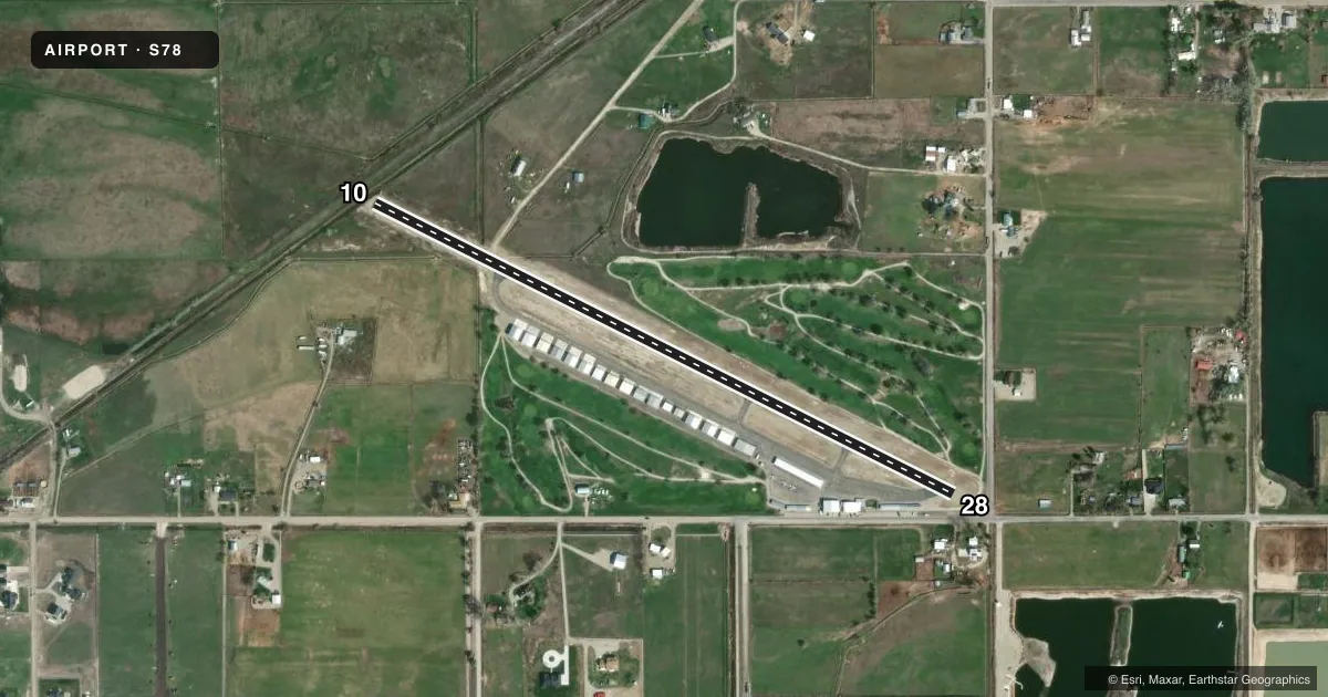
Runways & pattern
Full pagePattern entry · RWY 28
LEFT TRAFFICRunway end performance
| End | TORA | TODA | ASDA | LDA | VGSI | Approach lights | Obstruction |
|---|---|---|---|---|---|---|---|
| 10 | 2,934' | 2,934' | — | — | — | — | 25', tree, 207' from thr, 75' R of cntrln, slope 0 |
| 28 | 3,107' | 3,107' | — | — | — | — | 14', road, 200' from thr, 0' R of cntrln, slope 0 |
Declared distances in feet. TORA = takeoff run available, TODA = takeoff distance, ASDA = accelerate-stop, LDA = landing distance.
Airport sketch
Runways drawn to scale from FAA survey coordinates, rendered over satellite imagery. Not for navigation.
Approaches & charts
Services on the field
Fuel grades, oxygen, maintenance, ramp storage and lighting — as declared to the FAA by the airport operator.
Fuel & services
- Fuel
- 100LL
- Oxygen (bottled)
- Not available
- Oxygen (bulk)
- Not available
- Airframe repair
- Not available
- Power plant repair
- Not available
Ramp & ground
- Transient storage
- Tie-down
- Landing fee
- No fee published
- Customs
- Not available
- Lighting schedule
- SEE RMK
- Beacon schedule
- SS-SR
- Beacon
- White / Green (civil land)(WG)
- Wind indicator
- Lighted
- Segmented circle
- Yes
Fuel & FBOs
Cheapest 100LL and Jet A on the field and nearby. Always confirm with the FBO before taxi.
Airport notes
Surface conditions, obstructions, local procedures, lighting outages and other notes published with each FAA cycle.
General notes
- GOLF COURSE ON BOTH SIDES OF RWY.
- 1800' X 20' PVT GRVL AGG RWY LCTD ADJCNT NW OF ARPT.
- GOLF COURSE ROAD CROSSES NEAR RWY 28 THLD. WATCH FOR GOLFERS ON RWY.
- FOR CD CTC BIG SKY APCH AT 208-364-5860/5861.
Lighting notes
- ACTVT MIRL RY 10/28-CTAF.
Fuel notes
- 100LLFUEL AVBL 24 HRS SELF SER W/CREDIT CARD.
Approach & departure obstructions
- 2810 FT PVT ROAD AT 0 FT, 85 FT L; +5 FT FENCE AT 190 FT ON CNTRLN.
- 28RWY 28 360 FT DTHR MKD WITH W THLD BAR AND W ARROWS.
- 10RWY 10 190FT NON-STD. DTHR MKD W/YELLOW CHEVRONS.
- 10APCH SLP 0:1 AT END OF DTHR; 25 FT TREE @207 FT, 30R.
- 28+14 FT ROAD @15 FT, ON CNTR LINE, 0:1 SLP AT END OF DTHR.
Other notes
- ESTABD PRIOR TO 15 MAY 1959.
- MANAGERNEW AMGR/PUBLIC WORKS DIR.
- MANAGEREXTENSION 7
- OWNEREXT 7
VFR map & nearby airports
VFR sectional. Tap any ICAO chip to open that airport.
Key facts · S78
Answer card- ICAO
- S78
- Name
- EMMETT MUNI
- Location
- EMMETT, IDAHO
- Elevation
- 2,354 ft MSL
- Traffic pattern altitude
- 3,354 ft MSL (1,000 AGL)
- Control tower
- Non-towered (use CTAF)
- Total runways
- 1
- Longest runway
- 10/28 · 3,307 ft
- Published ILS approaches
- 0
- Published frequencies
- 1
- Magnetic variation
- 17°
- Current flight rules
- MVFR
- Current wind
- 250° at 11 kt
- Favored runway now
- RWY 28
Emmett Muni is in Emmett, Idaho. The field elevation is 2,354 ft MSL. It has one runway, 10/28, at 3,307 ft. There is no control tower. CTAF is 122.9. No ILS approaches are published.
Pattern altitude is not published. Use the standard 1,000 ft AGL pattern unless the current Chart Supplement or local procedures say otherwise. That puts the light piston pattern at about 3,354 ft MSL. The runway has published displaced thresholds on both ends. Runway 28 has a 360-foot displaced threshold. Runway 10 has a 190-foot non-standard displaced threshold.
Back Country Fuel Stop is on the field. It carries 100LL. Fuel is also published as available 24 hours self-service with credit card. The runway lighting is medium intensity and is activated by CTAF. Watch the runway environment closely. There is a golf course on both sides of the runway. Published remarks also call out obstructions near both ends. That includes a road and fence near runway 28. It also includes a tree off the runway 10 approach path. For clearance delivery, Big Sky Approach is listed in the remarks. A first-time pilot should plan a careful stabilized approach, brief the displaced thresholds and verify current airport details before departure.