METAR & TAF KEUL
Current METAR
Observed 16:56Z
KEUL 271656Z AUTO 28007KT 4SM HZ CLR 25/07 A3002 RMK AO2 SLP145 T02500072 $
- Wind
- 280° @ 7 kt
- Visibility
- 4 SM
- Temp / Dew
- 25°C / 7°C
- Altimeter
- 30.02 inHg
- Clouds
- CLR
- Density alt
- 4,091 ft
- Ceiling
- Unlimited
- Rules
- MVFR
Airport info & contacts
Manager on record, flight service, ARTCC, attendance schedule and pattern altitude — published by the FAA and refreshed every 28 days.
Location
- From city
- 3 NM SE
- VFR sectional
- SALT LAKE CITY
- ARTCC
- ZLC · SALT LAKE CITY
- NOTAM facility
- EUL (NOTAM-D)
Airport manager
- Name
- ROB OATES
- Phone
- 208-459-9779
- Address
- 4814 E. LINDEN STREET, CALDWELL ID 83605
Flight service · Hours
- FSS BOI
- BOISE1-800-WX-BRIEF
- Attendance
- MAR-OCT · 0800-1900
- NOV-FEB · 0800-1700
Frequencies
Tap any row to copy the frequency to your clipboard.
Runways & pattern
Full pagePattern entry · RWY 30
RIGHT TRAFFICRunway end performance
| End | TORA | TODA | ASDA | LDA | VGSI | Approach lights | Obstruction |
|---|---|---|---|---|---|---|---|
| 12 | — | — | — | — | PAPI 4-box left(3°) | — | 14', road, 560' from thr, 0' R of cntrln, slope 25 |
| 30 | — | — | — | — | PAPI 4-box left(3°) | — | — |
Declared distances in feet. TORA = takeoff run available, TODA = takeoff distance, ASDA = accelerate-stop, LDA = landing distance.
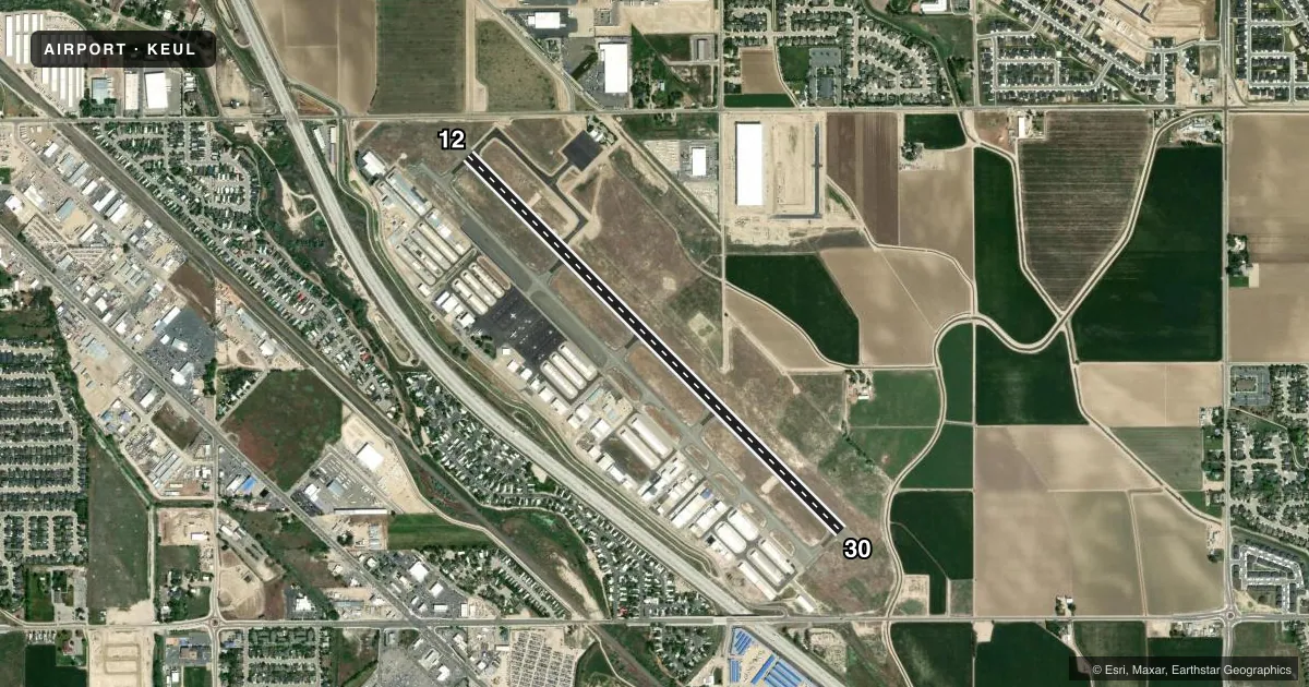
Airport sketch
Runways drawn to scale from FAA survey coordinates, rendered over satellite imagery. Not for navigation.
Approaches & charts
Services on the field
Fuel grades, oxygen, maintenance, ramp storage and lighting — as declared to the FAA by the airport operator.
Fuel & services
- Fuel
- 100LLAA+
- Oxygen (bottled)
- Not available
- Oxygen (bulk)
- HIGH/LOW
- Airframe repair
- Major
- Power plant repair
- Major
- Other services
- AVNCS,INSTR,PAJA,RNTL,SALES
Ramp & ground
- Transient storage
- Tie-down
- Landing fee
- No fee published
- Customs
- Not available
- Lighting schedule
- SEE RMK
- Beacon schedule
- SS-SR
- Beacon
- White / Green (civil land)(WG)
- Wind indicator
- Lighted
- Segmented circle
- Yes
Fuel & FBOs
Cheapest 100LL and Jet A on the field and nearby. Always confirm with the FBO before taxi.
Airport notes
Surface conditions, obstructions, local procedures, lighting outages and other notes published with each FAA cycle.
General notes
- +363 FT RADIO TWR LCTD 1.4 MILES NORTH OF ARPT.
- FUEL AVBL 24 HRS BY CREDIT CARD. JET A FROM TRUCK MON-SAT 1500-2300Z++. CALL 208-453-8577 FOR JET A AND AFTER HOURS CALLOUT.
- RWY 12 CALM WIND RWY.
- PREFERRED PARKING FOR JET AND LARGE TURBOPROP ACFT AVBL ON TERMINAL APRON ON NORTH SIDE OF RWY.
- TRANSIENT RAMP PREFERRED FOR USE BY TRAINING HELICOPTERS FOR LAUNCH AND RECOVERY.
- PREFERRED HELICOPTER PAT SW OF RWY.
- FOR CD CTC BIG SKY APCH AT 208-364-5860/5861.
- FBO MONITORS 122.85.
Lighting notes
- ACTVT MIRL RY 12/30 - CTAF. PAPI RYS 12 & 30 OPER CONTINUOUSLY.
Other notes
- 208-459-2360.
VFR map & nearby airports
VFR sectional. Tap any ICAO chip to open that airport.
Key facts · KEUL
Answer card- ICAO
- KEUL
- Name
- CALDWELL EXEC
- Location
- CALDWELL, IDAHO
- Elevation
- 2,431.4 ft MSL
- Traffic pattern altitude
- 3,431.4 ft MSL (1,000 AGL)
- Control tower
- Non-towered (use CTAF)
- Total runways
- 1
- Longest runway
- 12/30 · 5,500 ft
- Published ILS approaches
- 0
- Published frequencies
- 4
- Magnetic variation
- 16°
- Current flight rules
- MVFR
- Current wind
- 280° at 7 kt
- Favored runway now
- RWY 30
Caldwell Exec is in Caldwell, Idaho. The field elevation is 2,431.4 ft MSL. It has one runway. Runway 12/30 is 5,500 ft long with asphalt pavement. There is no control tower. Big Sky Approach handles clearance delivery. No ILS approaches are published here.
For pattern work, use the published traffic pattern altitude if it is available in the current Chart Supplement. If it is not published, use standard local procedures and verify before you go. The airport sits in the Treasure Valley, so expect a busy training and transient environment. A 363 ft radio tower sits 1.4 miles north of the airport. That is worth checking on the chart before arrival.
On the field, Silverhawk Aviation Academy carries 100LL, Jet A and Jet A Prist. Midfield Aviation carries 100LL. Qmulus Aviation carries Jet A. Fuel is available 24 hours by credit card. Jet A truck service is available Monday through Saturday from 1500 to 2300 Zulu and later. Runway 12 is the calm wind runway. The medium intensity runway lights are activated on CTAF. The PAPI on runways 12 and 30 operate continuously. The fixed base operator monitors 122.85. If you need a first call for clearance delivery, contact Big Sky Approach by phone before departure.