METAR & TAF S87
S87 does not publish a METAR.
Showing the nearest reporting station: KONO (ONTARIO MUNI) · 11.4 NM away. Conditions at S87 may differ.
METAR · KONO
Observed 12:15Z
KONO 271215Z AUTO VRB06KT 2 1/2SM HZ OVC022 21/04 A3000 RMK AO2 T02110039
- Wind
- VAR @ 6 kt
- Visibility
- 0.5 SM
- Temp / Dew
- 21°C / 4°C
- Altimeter
- 30.00 inHg
- Clouds
- OVC
- Density alt
- 3,250 ft
- Ceiling
- 2,200 ft AGL
- Rules
- LIFR
Airport info & contacts
Manager on record, flight service, ARTCC, attendance schedule and pattern altitude — published by the FAA and refreshed every 28 days.
Location
- From city
- 3 NM S
- VFR sectional
- SALT LAKE CITY
- ARTCC
- ZLC · SALT LAKE CITY
- NOTAM facility
- BOI (NOTAM-D)
Airport manager
- Name
- JIM METZGER
- Phone
- (360)-903-6901
- Address
- P O BOX 426, WEISER ID 83672
Flight service · Hours
- FSS BOI
- BOISE1-800-WX-BRIEF
- Attendance
- MON-SAT · 0900 - 1700
Frequencies
Tap any row to copy the frequency to your clipboard.
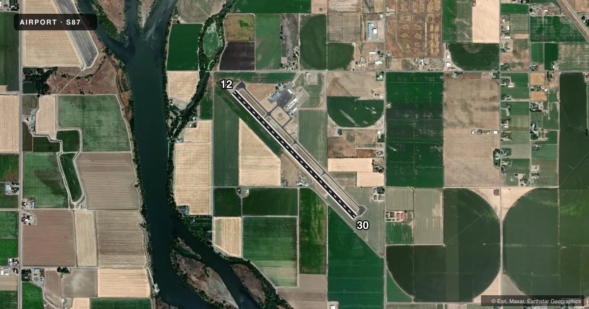
Runways & pattern
Full pagePattern entry · RWY 30
LEFT TRAFFICRunway end performance
| End | TORA | TODA | ASDA | LDA | VGSI | Approach lights | Obstruction |
|---|---|---|---|---|---|---|---|
| 12 | — | — | — | — | — | — | 50', trees, 800' from thr, 0' R of cntrln, slope 12 |
| 30 | — | — | — | — | PAPI 4-box left(3°) | — | 8', fence, 200' from thr, 190' R of cntrln, slope 0 |
Declared distances in feet. TORA = takeoff run available, TODA = takeoff distance, ASDA = accelerate-stop, LDA = landing distance.
Airport sketch
Runways drawn to scale from FAA survey coordinates, rendered over satellite imagery. Not for navigation.
Approaches & charts
Services on the field
Fuel grades, oxygen, maintenance, ramp storage and lighting — as declared to the FAA by the airport operator.
Fuel & services
- Fuel
- 100LL
- Oxygen (bottled)
- Not available
- Oxygen (bulk)
- Not available
- Airframe repair
- Minor
- Power plant repair
- Minor
- Other services
- AGRI,INSTR
Ramp & ground
- Transient storage
- Tie-down
- Hangar
- Landing fee
- No fee published
- Customs
- Not available
- Lighting schedule
- SEE RMK
- Beacon schedule
- SS-SR
- Beacon
- White / Green (civil land)(WG)
- Wind indicator
- Lighted
- Segmented circle
- Yes
Fuel & FBOs
Cheapest 100LL and Jet A on the field and nearby. Always confirm with the FBO before taxi.
Airport notes
Surface conditions, obstructions, local procedures, lighting outages and other notes published with each FAA cycle.
General notes
- EXTSV AGRICULTURAL OPNS MAR-OCT.
- BIRDS ON & INVOF ARPT.
- FOR CD CTC SALT LAKE ARTCC AT 801-320-2568.
Lighting notes
- ACTVT MIRL RWY 12/30; REIL RWY 12 & 30 - CTAF. PAPI RWY 30 UNUSBL DURING GROWING SEASON - MAY TO SEP EACH YR, DUE TO VEG/CROPS BLOCKING VIS OF LIGHTS. MIRL AND REIL LIGHT SYS ON PHOTOCELL SENSOR AND ONLY ACTV DURG HRS OF DARKNESS.
Other notes
- ESTABD PRIOR TO 15 MAY 1959.
VFR map & nearby airports
VFR sectional. Tap any ICAO chip to open that airport.
Key facts · S87
Answer card- ICAO
- S87
- Name
- WEISER MUNI
- Location
- WEISER, IDAHO
- Elevation
- 2,120.3 ft MSL
- Traffic pattern altitude
- 3,120.3 ft MSL (1,000 AGL)
- Control tower
- Non-towered (use CTAF)
- Total runways
- 1
- Longest runway
- 12/30 · 4,000 ft
- Published ILS approaches
- 0
- Published frequencies
- 2
- Magnetic variation
- 15°
- Current flight rules
- LIFR
- Current wind
- 000° at 6 kt
- Favored runway now
- RWY 30
Weiser Muni is in Weiser, Idaho. The field elevation is 2,120.3 ft MSL. It has one runway, 12/30, which is 4,000 ft long and paved. There is no control tower. CTAF and UNICOM are both 122.8. No ILS approaches are published here.
Pattern altitude is not published. Use the standard 1,000 ft AGL for light piston traffic unless the current FAA Chart Supplement says otherwise. The on-field FBO is Weiser Municipal Airport. It carries 100LL. Call (360) 903-6901 before arrival if you need current service details.
The airport has medium intensity runway lights on 12/30. The runway end identifier lights are tied to CTAF control. The PAPI on runway 30 is unusable from May through September because crops and vegetation block the lights. The lights are on a photocell, so they only come on in darkness. Birds are reported on and near the airport. Agricultural activity is heavy from March through October, so expect that traffic and field work around the airport. For clearance delivery, contact Salt Lake ARTCC. Check the current FAA Chart Supplement for any additional local procedures before you go.