METAR & TAF U76
U76 does not publish a METAR.
Showing the nearest reporting station: KBOI (BOISE AIR TRML/GOWEN FLD) · 33.7 NM away. Conditions at U76 may differ.
METAR · KBOI
Observed 16:41Z
KBOI 271641Z 30007KT 1 3/4SM FU OVC014 23/07 A3004 RMK AO2 SFC VIS 2 T02280072
- Wind
- 300° @ 7 kt
- Visibility
- 0.75 SM
- Temp / Dew
- 23°C / 7°C
- Altimeter
- 30.04 inHg
- Clouds
- OVC
- Density alt
- 4,738 ft
- Ceiling
- 1,400 ft AGL
- Rules
- LIFR
Airport info & contacts
Manager on record, flight service, ARTCC, attendance schedule and pattern altitude — published by the FAA and refreshed every 28 days.
Location
- From city
- 2 NM W
- VFR sectional
- SALT LAKE CITY
- ARTCC
- ZLC · SALT LAKE CITY
- NOTAM facility
- BOI (NOTAM-D)
Airport manager
- Name
- THOMAS HOEGG
- Phone
- 208-599-0609
- Address
- 2614 AIRBASE RD, MOUNTAIN HOME ID 83647
Flight service · Hours
- FSS BOI
- BOISE1-800-WX-BRIEF
- Attendance
- MON-FRI · 0800-1700
Frequencies
Tap any row to copy the frequency to your clipboard.
Runways & pattern
Full pagePattern entry · RWY 28
LEFT TRAFFICRunway end performance
| End | TORA | TODA | ASDA | LDA | VGSI | Approach lights | Obstruction |
|---|---|---|---|---|---|---|---|
| 10 | — | — | — | — | PAPI 2-box left(3°) | — | — |
| 28 | — | — | — | — | PAPI 2-box left(3°) | — | 50', pline, 1400' from thr, 0' R of cntrln, slope 24 |
Declared distances in feet. TORA = takeoff run available, TODA = takeoff distance, ASDA = accelerate-stop, LDA = landing distance.
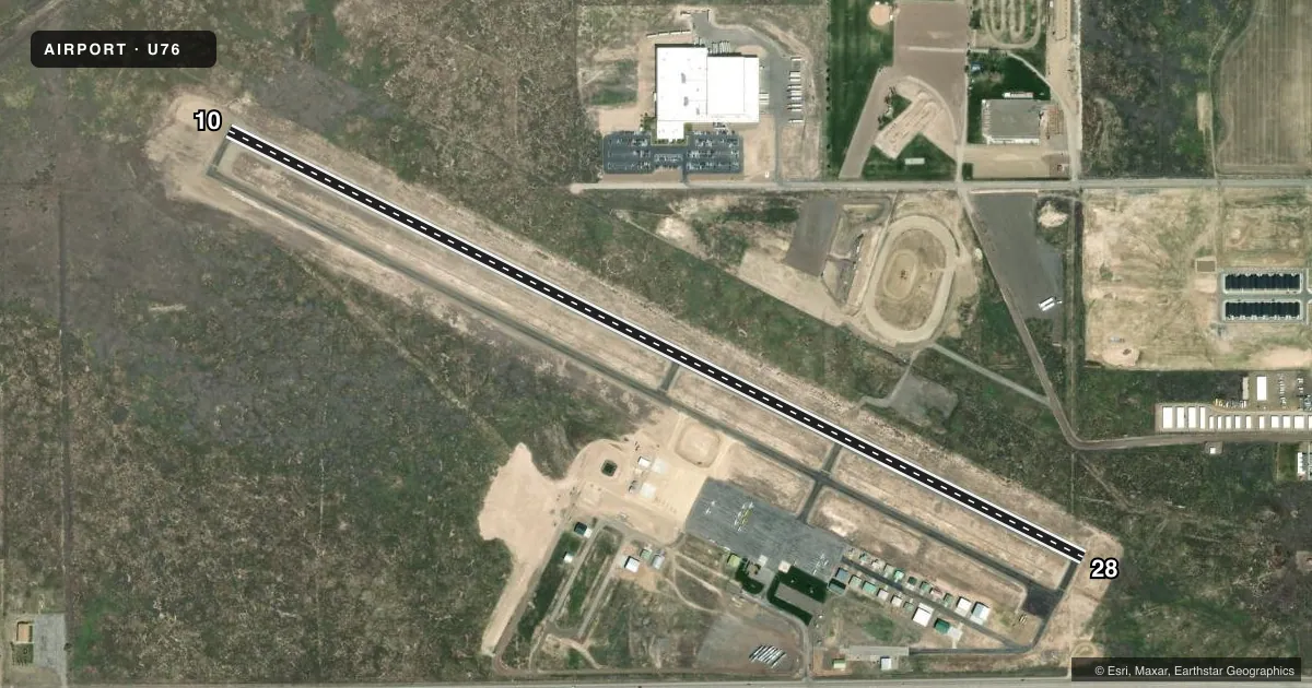
Airport sketch
Runways drawn to scale from FAA survey coordinates, rendered over satellite imagery. Not for navigation.
Approaches & charts
Services on the field
Fuel grades, oxygen, maintenance, ramp storage and lighting — as declared to the FAA by the airport operator.
Fuel & services
- Fuel
- 100LLA
- Oxygen (bottled)
- Not available
- Oxygen (bulk)
- Not available
- Airframe repair
- Major
- Power plant repair
- Major
- Other services
- AGRI,INSTR,RNTL
Ramp & ground
- Transient storage
- Tie-down
- Landing fee
- No fee published
- Customs
- Not available
- Lighting schedule
- SEE RMK
- Beacon schedule
- SS-SR
- Beacon
- White / Green (civil land)(WG)
- Wind indicator
- Lighted
- Segmented circle
- Yes
Fuel & FBOs
Cheapest 100LL and Jet A on the field and nearby. Always confirm with the FBO before taxi.
Airport notes
Surface conditions, obstructions, local procedures, lighting outages and other notes published with each FAA cycle.
General notes
- HIGH PERFORMANCE MIL JET OPNS CONDUCTED AT MOUNTAIN HOME AFB 8 NM SW OF ARPT.
- EXTSV AGRICULTURAL & FIRE OPS (MAY - AUG OF EACH YR).
Lighting notes
- ACTVT REILS RWY 10 & 28; PAPI RWY 10 & 28; MIRL RWY 10/28 - CTAF 5 CLICKS.
Fuel notes
- 100LL100LL AVBL 24 HRS WITH CREDIT CARD.
- AJET A AVBL 24 HRS WITH CREDIT CARD. JET A SINGLE POINT AVBL MON-FRI 1500-0100Z OR BY APPOINTMENT CALL (208) 599-0609.
Other notes
- AUTOMATED UNICOM.
- MANAGEREMAIL: ALTITUDEU76@GMAIL.COM
VFR map & nearby airports
VFR sectional. Tap any ICAO chip to open that airport.
Key facts · U76
Answer card- ICAO
- U76
- Name
- MOUNTAIN HOME MUNI
- Location
- MOUNTAIN HOME, IDAHO
- Elevation
- 3,166.6 ft MSL
- Traffic pattern altitude
- 4,166.6 ft MSL (1,000 AGL)
- Control tower
- Non-towered (use CTAF)
- Total runways
- 1
- Longest runway
- 10/28 · 5,000 ft
- Published ILS approaches
- 0
- Published frequencies
- 4
- Magnetic variation
- 13°
- Current flight rules
- LIFR
- Current wind
- 300° at 7 kt
- Favored runway now
- RWY 28
Mountain Home Muni sits in Mountain Home, Idaho at 3,166.6 ft MSL. It has one runway, 10/28, which is 5,000 ft long. There is no control tower. Pattern altitude is not published, so use 1,000 ft AGL for light piston traffic unless the current Chart Supplement says otherwise. No ILS approaches are published here.
Altitude Aviation Services is on the field. It carries 100LL, Jet A and Jet A Prist. 100LL is available 24 hours with a credit card. Jet A is also available 24 hours with a credit card. The airport remarks also note that Jet A single-point fueling is available Monday through Friday from 1500 to 0100 Zulu or by appointment by calling the FBO.
This is a field where you want to stay sharp on traffic and runway lighting. Runway 10 and 28 have REILs and PAPI. Medium intensity runway lights are controlled with five clicks on CTAF. An automated UNICOM is in use. The bigger operational item is nearby military jet activity from Mountain Home Air Force Base, which sits 8 NM southwest of the airport. Agricultural and fire operations are also common from May through August. Check the current Chart Supplement for any local procedures before you go.