METAR & TAF 2U0
2U0 does not publish a METAR.
Showing the nearest reporting station: KBOI (BOISE AIR TRML/GOWEN FLD) · 29.7 NM away. Conditions at 2U0 may differ.
METAR · KBOI
Observed 17:41Z
KBOI 271741Z 29008KT 1SM R10R/P6000FT FU VV016 25/07 A3003 RMK AO2 T02500072
- Wind
- 290° @ 8 kt
- Visibility
- 1 SM
- Temp / Dew
- 25°C / 7°C
- Altimeter
- 30.03 inHg
- Clouds
- VV
- Density alt
- 7,212 ft
- Ceiling
- 1,600 ft AGL
- Rules
- IFR
Airport info & contacts
Manager on record, flight service, ARTCC, attendance schedule and pattern altitude — published by the FAA and refreshed every 28 days.
Location
- From city
- 2 NM SE
- VFR sectional
- SALT LAKE CITY
- ARTCC
- ZLC · SALT LAKE CITY
- NOTAM facility
- BOI (NOTAM-D)
Airport manager
- Name
- IDAHO DIV OF AERONAUTICS
- Phone
- 208-334-8775
- Address
- P.O. BOX 7129, BOISE ID 83707-1129
Flight service · Hours
- FSS BOI
- BOISE1-800-WX-BRIEF
- Attendance
- Unattended
Frequencies
Tap any row to copy the frequency to your clipboard.
Runways & pattern
Full pagePattern entry · RWY 24
LEFT TRAFFICRunway end performance
| End | TORA | TODA | ASDA | LDA | VGSI | Approach lights | Obstruction |
|---|---|---|---|---|---|---|---|
| 06 | — | — | — | — | — | — | 4', fence, 0' from thr, 170' R of cntrln, slope 0 |
| 24 | — | — | — | — | — | — | 12', bldg, 75' from thr, 70' R of cntrln, slope 6 |
Declared distances in feet. TORA = takeoff run available, TODA = takeoff distance, ASDA = accelerate-stop, LDA = landing distance.
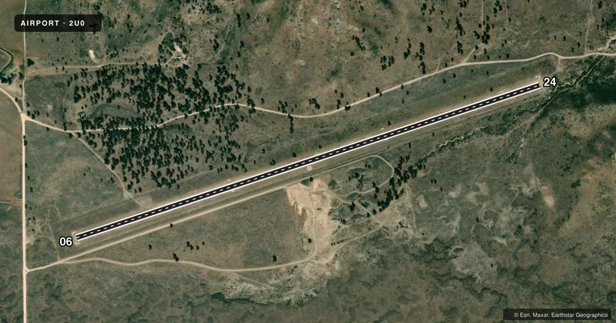
Airport sketch
Runways drawn to scale from FAA survey coordinates, rendered over satellite imagery. Not for navigation.
Approaches & charts
Services on the field
Fuel grades, oxygen, maintenance, ramp storage and lighting — as declared to the FAA by the airport operator.
Fuel & services
- Fuel
- Not available
- Oxygen (bottled)
- Not available
- Oxygen (bulk)
- Not available
- Airframe repair
- Not available
- Power plant repair
- Not available
Ramp & ground
- Transient storage
- Tie-down
- Landing fee
- No fee published
- Customs
- Not available
- Wind indicator
- Yes
- Segmented circle
- Yes
Fuel & FBOs
Cheapest 100LL and Jet A on the field and nearby. Always confirm with the FBO before taxi.
Airport notes
Surface conditions, obstructions, local procedures, lighting outages and other notes published with each FAA cycle.
General notes
- NO WINTER MAINT.
- RCMD LAND RWY 06; TKOF RWY 24 WHEN WND COND PERMITS.
- NO FONE AVBL AT ARPT.
- FOR CD CTC BIG SKY APCH AT 208-364-5860/5861.
- RWY 24 - RT SIDE OF RWY CNTRLN HAS 1200 FT X 25 FT PRACTICE AREA MKD BY INGORUND, WHITE ROCK MKRS - INTENDED FOR PRACTICE BEFORE VENTURING OUT INTO MORE CHALLENGING BACKCOUNTRY AIRSTRIPS.
Approach & departure obstructions
- 06RWY 6 RIGHT TFC & RWY 24 LEFT TFC TO AVOID OVR FLT OF CITY.
- 0606/24 EDGES & THRS MARKED WITH WHITE ROCKS.
- 06CTLG OBSTN IS A 4 FT BARB WIRE FENCE AT 0 FT, 170 FT RT.
Other notes
- ESTABD PRIOR TO 1959.
VFR map & nearby airports
VFR sectional. Tap any ICAO chip to open that airport.
Key facts · 2U0
Answer card- ICAO
- 2U0
- Name
- SMITH PRAIRIE
- Location
- PRAIRIE, IDAHO
- Elevation
- 4,958 ft MSL
- Traffic pattern altitude
- 5,958 ft MSL (1,000 AGL)
- Control tower
- Non-towered (use CTAF)
- Total runways
- 1
- Longest runway
- 06/24 · 5,400 ft
- Published ILS approaches
- 0
- Published frequencies
- 1
- Magnetic variation
- 17°
- Current flight rules
- IFR
- Current wind
- 290° at 8 kt
- Favored runway now
- RWY 24
Smith Prairie Airport (2U0) sits in Prairie, Idaho at 4,958 ft MSL. It has one runway, 06/24, which is 5,400 ft long and surfaced turf-dirt. No control tower is published. CTAF is 122.9. No ILS approaches are published here.
The published pattern altitude is not listed, so use the standard 1,000 ft AGL for light piston operations unless the current FAA Chart Supplement says otherwise. Runway 06/24 edges and thresholds are marked with white rocks. The field has no on-field FBOs listed. No telephone is available at the airport. The airport is also noted as established prior to 1959.
For clearance delivery, contact Big Sky Approach at 208-364-5860 or 208-364-5861. The published remarks also say runway 06 is the recommended landing runway. Runway 24 is the recommended takeoff runway when wind conditions permit. Runway 6 uses right traffic. Runway 24 uses left traffic to help avoid overflight of the city. There is no winter maintenance, so surface condition checks matter before arrival. At this elevation, plan for higher density altitude effects, especially on warm days. Verify current field conditions and any local procedures with the current FAA Chart Supplement or the airport operator before you go.