METAR & TAF 1U9
1U9 does not publish a METAR.
Showing the nearest reporting station: KBOI (BOISE AIR TRML/GOWEN FLD) · 40.2 NM away. Conditions at 1U9 may differ.
METAR · KBOI
Observed 14:53Z
KBOI 271453Z 00000KT 1 3/4SM FU OVC019 19/08 A3003 RMK AO2 SLP141 T01890083 53009
- Wind
- 000° @ 0 kt
- Visibility
- 0.75 SM
- Temp / Dew
- 19°C / 8°C
- Altimeter
- 30.03 inHg
- Clouds
- OVC
- Density alt
- 5,591 ft
- Ceiling
- 1,900 ft AGL
- Rules
- LIFR
Airport info & contacts
Manager on record, flight service, ARTCC, attendance schedule and pattern altitude — published by the FAA and refreshed every 28 days.
Location
- From city
- 1 NM S
- VFR sectional
- SALT LAKE CITY
- ARTCC
- ZLC · SALT LAKE CITY
- NOTAM facility
- BOI (NOTAM-D)
Airport manager
- Name
- ID DIV OF AERONAUTICS
- Phone
- 208-334-8775
- Address
- P.O. BOX 7129, BOISE ID 83707-1129
Flight service · Hours
- FSS BOI
- BOISE1-800-WX-BRIEF
- Attendance
- Unattended
Frequencies
Tap any row to copy the frequency to your clipboard.
Runways & pattern
Full pagePattern entry · RWY 16
LEFT TRAFFICRunway end performance
| End | TORA | TODA | ASDA | LDA | VGSI | Approach lights | Obstruction |
|---|---|---|---|---|---|---|---|
| 16 | — | — | — | — | — | — | 17', road, 0' from thr, 115' R of cntrln, slope 0 |
| 34 | — | — | — | — | — | — | 12', road, 75' from thr, 0' R of cntrln, slope 6 |
Declared distances in feet. TORA = takeoff run available, TODA = takeoff distance, ASDA = accelerate-stop, LDA = landing distance.
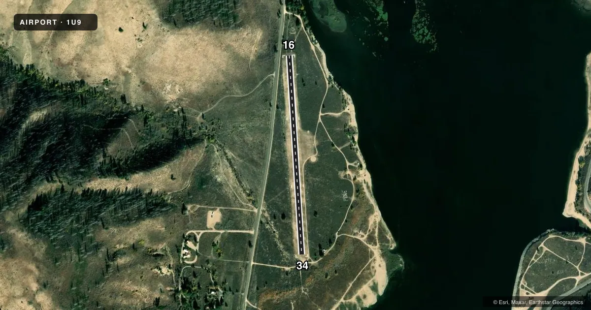
Airport sketch
Runways drawn to scale from FAA survey coordinates, rendered over satellite imagery. Not for navigation.
Approaches & charts
Services on the field
Fuel grades, oxygen, maintenance, ramp storage and lighting — as declared to the FAA by the airport operator.
Fuel & services
- Fuel
- Not available
- Oxygen (bottled)
- Not available
- Oxygen (bulk)
- Not available
- Airframe repair
- Not available
- Power plant repair
- Not available
Ramp & ground
- Transient storage
- Tie-down
- Landing fee
- No fee published
- Customs
- Not available
- Wind indicator
- Yes
- Segmented circle
- Yes
Fuel & FBOs
Cheapest 100LL and Jet A on the field and nearby. Always confirm with the FBO before taxi.
Airport notes
Surface conditions, obstructions, local procedures, lighting outages and other notes published with each FAA cycle.
General notes
- NO WINTER MAINTENANCE.
- NO LINE OF SIGHT BETWEEN RWY ENDS.
- RECOMMEND LAND RY 34 & TAKEOFF R\Y 16 WHEN WIND CONDITIONS PERMIT.
- RY HAS SIDESLOPE, DOWNHILL FM WEST TO EAST.
- FOR CD CTC BIG SKY APCH AT 208-364-5860/5861.
Approach & departure obstructions
- 1616/34 EDGES & THRS MARKED WITH WHITE ROCKS.
- 16RWY 16 +450 FT TIMBERED RIDGE AT 2000 FT ON CNTRLN; +50 FT TREE AT 300 FT, 80 FT LEFT; +75 FT TREES AT 550 FT ON CNTRLN; +30 FT TREE AT 100 FT, 70 FT RIGHT.
Other notes
- ESTABD PRIOR TO 1959.
VFR map & nearby airports
VFR sectional. Tap any ICAO chip to open that airport.
Key facts · 1U9
Answer card- ICAO
- 1U9
- Name
- PINE
- Location
- PINE, IDAHO
- Elevation
- 4,232 ft MSL
- Traffic pattern altitude
- 5,232 ft MSL (1,000 AGL)
- Control tower
- Non-towered (use CTAF)
- Total runways
- 1
- Longest runway
- 16/34 · 2,300 ft
- Published ILS approaches
- 0
- Published frequencies
- 1
- Magnetic variation
- 17°
- Current flight rules
- LIFR
- Current wind
- 000° at 0 kt
- Favored runway now
- –
PINE (1U9) sits in Idaho at 4,232 ft MSL. It has one runway, 16/34, which is 2,300 ft long and turf. There is no control tower. CTAF is 122.9. No ILS approaches are published here.
The pattern altitude is not published. Use the standard 1,000 ft AGL pattern unless current local guidance says otherwise. The field sits in a mountain environment with a 17° magnetic variation. That matters for planning. Density altitude can be a factor at this elevation, especially on warm days. The runway also has a sideslope, with the surface downhill from west to east. There is no line of sight between the runway ends.
Published remarks call out several obstructions near runway 16. A timbered ridge sits on centerline beyond the approach end. Trees are also noted left and right of centerline. The FAA also says no winter maintenance is provided. For clearance delivery, contact Big Sky Approach at the numbers listed in the Chart Supplement. The remarks recommend landing runway 34 and taking off runway 16 when wind conditions permit. There are no on-field FBOs listed, so verify services before you go.