METAR & TAF 52U
52U does not publish a METAR.
Showing the nearest reporting station: KBOI (BOISE AIR TRML/GOWEN FLD) · 41.7 NM away. Conditions at 52U may differ.
METAR · KBOI
Observed 15:53Z
KBOI 271553Z 27003KT 1 3/4SM FU OVC016 21/08 A3003 RMK AO2 SLP141 T02060083
- Wind
- 270° @ 3 kt
- Visibility
- 0.75 SM
- Temp / Dew
- 21°C / 8°C
- Altimeter
- 30.03 inHg
- Clouds
- OVC
- Density alt
- 6,167 ft
- Ceiling
- 1,600 ft AGL
- Rules
- LIFR
Airport info & contacts
Manager on record, flight service, ARTCC, attendance schedule and pattern altitude — published by the FAA and refreshed every 28 days.
Location
- From city
- 9 NM NW
- VFR sectional
- SALT LAKE CITY
- ARTCC
- ZLC · SALT LAKE CITY
- NOTAM facility
- BOI (NOTAM-D)
Airport manager
- Name
- COLIN GOOD-FIRE MGMT OFFICER-USFS
- Phone
- 208-869-2525
- Address
- 3383 HWY 21 OR P.O.BOX 129, PO BOX 129, IDAHO CITY ID 83631
Flight service · Hours
- FSS BOI
- BOISE1-800-WX-BRIEF
- Attendance
- Unattended
Frequencies
Tap any row to copy the frequency to your clipboard.
Runways & pattern
Full pagePattern entry · RWY 21
LEFT TRAFFICRunway end performance
| End | TORA | TODA | ASDA | LDA | VGSI | Approach lights | Obstruction |
|---|---|---|---|---|---|---|---|
| 03 | — | — | — | — | — | — | 40', tree, 0' from thr, 60' R of cntrln, slope 0 |
| 21 | — | — | — | — | — | — | 80', tree, 20' from thr, 75' R of cntrln, slope 1 |
Declared distances in feet. TORA = takeoff run available, TODA = takeoff distance, ASDA = accelerate-stop, LDA = landing distance.
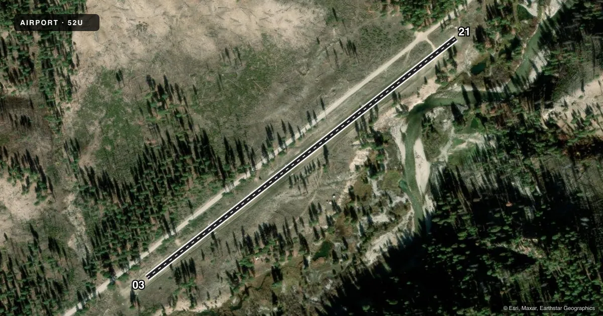
Airport sketch
Runways drawn to scale from FAA survey coordinates, rendered over satellite imagery. Not for navigation.
Approaches & charts
Services on the field
Fuel grades, oxygen, maintenance, ramp storage and lighting — as declared to the FAA by the airport operator.
Fuel & services
- Fuel
- Not available
- Oxygen (bottled)
- Not available
- Oxygen (bulk)
- Not available
- Airframe repair
- Not available
- Power plant repair
- Not available
Ramp & ground
- Transient storage
- Tie-down
- Landing fee
- No fee published
- Wind indicator
- Yes
- Segmented circle
- No
Fuel & FBOs
Cheapest 100LL and Jet A on the field and nearby. Always confirm with the FBO before taxi.
Airport notes
Surface conditions, obstructions, local procedures, lighting outages and other notes published with each FAA cycle.
General notes
- RECOMMEND LNDG RWY 03; TKOF RWY 21 WHEN WIND CONDITIONS ALLOW.
- ARPT LCTD IN NRW RIVER CANYON SUBJECT TO LCL TURBC CAUSED BY THE TRRN CONFIGN.
- NO WINTER MAINTENANCE.
- -2' DITCHES PARALLEL TO BOTH SIDES OF RWY.
- NO TELEPHONE AVBL AT ARPT.
- FOR CD CTC SALT LAKE ARTCC AT 801-320-2568.
Approach & departure obstructions
- 03RY 03/21 THRS & EDGES MKD WITH PAINTED ROCKS.
- 03CTLG OBSTN EXCEEDS 45 DEG SLP - 40 FT TREE AT O FT, 60 FT LEFT. CLOSE TO LEFT BDRY MKR RWY 03 END.
- 03+60 FT TREES IN APCH 80-125 FT L & 100-500 FT FM END OF RWY; +18 FT ROAD AT 0 FT 105 FT L.
- 2130 FT TREES AT 50 FT 80 FT LEFT; 15 FT ROAD 0 FT 120 FEET RIGHT; 40 FT TREES AT 350 ON CNTRLN; 30 FT TREES AT 250 FT 50 FT RIGHT; 1000 FT TIMBERED RIDGE AT 3500 FT ON CNTRLN.
Other notes
- ESTABLD PRIOR TO 1958.
VFR map & nearby airports
VFR sectional. Tap any ICAO chip to open that airport.
Key facts · 52U
Answer card- ICAO
- 52U
- Name
- WEATHERBY USFS
- Location
- ATLANTA, IDAHO
- Elevation
- 4,503 ft MSL
- Traffic pattern altitude
- 5,503 ft MSL (1,000 AGL)
- Control tower
- Non-towered (use CTAF)
- Total runways
- 1
- Longest runway
- 03/21 · 2,200 ft
- Published ILS approaches
- 0
- Published frequencies
- 1
- Magnetic variation
- 17°
- Current flight rules
- LIFR
- Current wind
- 270° at 3 kt
- Favored runway now
- RWY 21
WEATHERBY USFS (52U) sits near Atlanta, Idaho in North River Canyon. Field elevation is 4,503 ft MSL. The airport has one runway. Runway 03/21 is 2,200 ft long with a turf-dirt surface. No control tower is published. CTAF is 122.9. No ILS approaches are published.
Pattern altitude is not published. Use the standard 1,000 ft AGL pattern unless the current FAA Chart Supplement says otherwise. That puts the light-piston pattern at about 5,503 ft MSL. The field is in terrain that can make the air rough. Published remarks call out local turbulence from the canyon. There are also 2-foot ditches parallel to both sides of the runway. Thresholds and edges on 03 and 21 are marked with painted rocks.
For a first-time arrival, plan for the elevation and the terrain. The airport is at high density altitude country. The published remarks also recommend landing runway 03 and taking off runway 21 when wind allows. No winter maintenance is provided. No telephone is available at the airport. No on-field FBOs are listed, so verify current services with the airport operator or the FBO directly by phone before you go.