METAR & TAF 2U7
2U7 does not publish a METAR.
Showing the nearest reporting station: KLLJ (CHALLIS) · 36.1 NM away. Conditions at 2U7 may differ.
METAR · KLLJ
Observed 12:55Z
KLLJ 271255Z AUTO 00000KT 9SM CLR 14/03 A3014 RMK AO2 SLP134 T01390033 $
- Wind
- 000° @ 0 kt
- Visibility
- 9 SM
- Temp / Dew
- 14°C / 3°C
- Altimeter
- 30.14 inHg
- Clouds
- CLR
- Density alt
- 7,547 ft
- Ceiling
- Unlimited
- Rules
- VFR
Airport info & contacts
Manager on record, flight service, ARTCC, attendance schedule and pattern altitude — published by the FAA and refreshed every 28 days.
Location
- From city
- 1 NM SE
- VFR sectional
- SALT LAKE CITY
- ARTCC
- ZLC · SALT LAKE CITY
- NOTAM facility
- BOI (NOTAM-D)
Airport manager
- Name
- DIV OF AERONAUTICS
- Phone
- 208-334-8775
- Address
- P O BOX 7129, BOISE ID 83707-1129
Flight service · Hours
- FSS BOI
- BOISE1-800-WX-BRIEF
- Attendance
- Unattended
Frequencies
Tap any row to copy the frequency to your clipboard.
Runways & pattern
Full pagePattern entry · RWY 17
LEFT TRAFFICRunway end performance
| End | TORA | TODA | ASDA | LDA | VGSI | Approach lights | Obstruction |
|---|---|---|---|---|---|---|---|
| 17 | — | — | — | — | — | — | 18', trees, 170' from thr, 60' R of cntrln, slope 9 |
| 35 | — | — | — | — | — | — | 5', fence, 0' from thr, 90' R of cntrln, slope 0 |
Declared distances in feet. TORA = takeoff run available, TODA = takeoff distance, ASDA = accelerate-stop, LDA = landing distance.
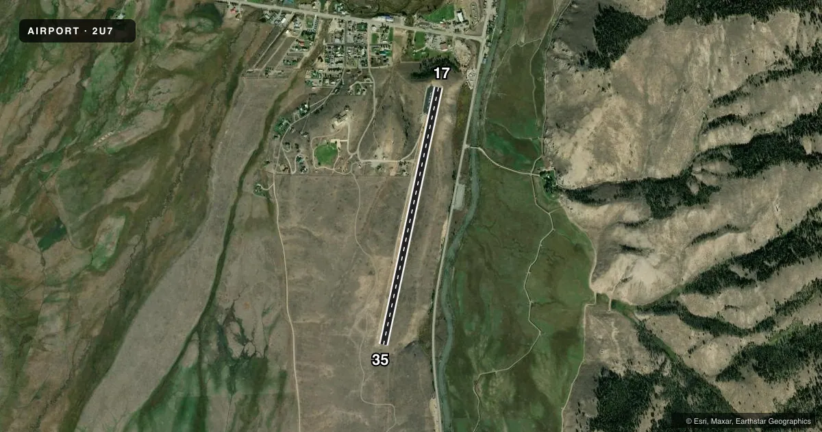
Airport sketch
Runways drawn to scale from FAA survey coordinates, rendered over satellite imagery. Not for navigation.
Approaches & charts
Services on the field
Fuel grades, oxygen, maintenance, ramp storage and lighting — as declared to the FAA by the airport operator.
Fuel & services
- Fuel
- Not available
- Oxygen (bottled)
- Not available
- Oxygen (bulk)
- Not available
- Airframe repair
- Not available
- Power plant repair
- Not available
- Other services
- CHTR
Ramp & ground
- Transient storage
- Tie-down
- Landing fee
- No fee published
- Customs
- Not available
- Wind indicator
- Yes
- Segmented circle
- Yes
Fuel & FBOs
Cheapest 100LL and Jet A on the field and nearby. Always confirm with the FBO before taxi.
Airport notes
Surface conditions, obstructions, local procedures, lighting outages and other notes published with each FAA cycle.
General notes
- NO WINTER MAINTENANCE.
- ARPT LCTD IN VALLEY SURROUNDED BY HIGH MOUNTAINOUS TRRN.
- NUMEROUS AIR TAXI OPNS DURG SUMMER MONTHS.
- FOR CD CTC SALT LAKE ARTCC AT 801-320-2568.
Runway surface & condition
- 17/35RWY 17/35 FST 1600 FT OF RWY 17 IS ASPH, RMNDR IS DIRT.
Approach & departure obstructions
- 1717/35 RY EDGES AND THRS MARKED WITH WHITE ROCKS.
Other notes
- ESTABD PRIOR TO 1959.
- STAN HARRAH LEASES A PORTION OF ARPT PROPERTY FROM US GOVT.
- SEGMENTED CRC N END NSTD - HALF CRC ONLY.
- ACFT BASED AT ARPT DURING SUMMER MONTHS ONLY.
VFR map & nearby airports
VFR sectional. Tap any ICAO chip to open that airport.
Key facts · 2U7
Answer card- ICAO
- 2U7
- Name
- STANLEY
- Location
- STANLEY, IDAHO
- Elevation
- 6,403 ft MSL
- Traffic pattern altitude
- 7,403 ft MSL (1,000 AGL)
- Control tower
- Non-towered (use CTAF)
- Total runways
- 1
- Longest runway
- 17/35 · 4,300 ft
- Published ILS approaches
- 0
- Published frequencies
- 1
- Magnetic variation
- 17°
- Current flight rules
- VFR
- Current wind
- 000° at 0 kt
- Favored runway now
- –
Stanley Airport (2U7) is in Stanley, Idaho. The field elevation is 6,403 ft MSL. It has one runway. Runway 17/35 is 4,300 ft long. The airport is not towered. CTAF is 122.9. No ILS approaches are published.
The published pattern altitude is not listed, so use the standard 1,000 ft AGL for light piston aircraft unless the current FAA Chart Supplement says otherwise. That puts the pattern at 7,403 ft MSL. The airport sits in a valley with high mountainous terrain around it. That matters for climb performance, density altitude and arrival planning. No winter maintenance is provided. Summer use is active. The remarks say aircraft are based there during the summer months only. Numerous air taxi operations also occur in summer.
Runway 17/35 has a mixed surface. The first 1,600 ft of Runway 17 is paved with asphalt. The rest is dirt. Runway edges and thresholds are marked with white rocks. The segmented circle at the north end is nonstandard. Only half of the circle is present. There are no on-field FBOs listed. Verify fuel and services with the airport operator or the FBO directly by phone before you go. For clearance delivery, contact Salt Lake ARTCC at 801-320-2568.