METAR & TAF 2U8
2U8 does not publish a METAR.
Showing the nearest reporting station: KLLJ (CHALLIS) · 35.7 NM away. Conditions at 2U8 may differ.
METAR · KLLJ
Observed 17:55Z
KLLJ 261755Z AUTO VRB05KT 10SM FEW043 SCT100 SCT120 23/07 A3013 RMK AO2 RAB34E44 SLP133 P0000 60000 T02330067 10233 20139 58007 $
- Wind
- VAR @ 5 kt
- Visibility
- 10 SM
- Temp / Dew
- 23°C / 7°C
- Altimeter
- 30.13 inHg
- Clouds
- SCT
- Density alt
- 6,174 ft
- Ceiling
- Unlimited
- Rules
- VFR
Airport info & contacts
Manager on record, flight service, ARTCC, attendance schedule and pattern altitude — published by the FAA and refreshed every 28 days.
Location
- From city
- 31 NM N
- VFR sectional
- GREAT FALLS
- ARTCC
- ZLC · SALT LAKE CITY
- NOTAM facility
- BOI (NOTAM-D)
Airport manager
- Name
- ID DIV OF AERONAUTICS
- Phone
- 208-334-8775
- Address
- PO BOX 7129, BOISE ID 83707-1129
Flight service · Hours
- FSS BOI
- BOISE1-800-WX-BRIEF
- Attendance
- Unattended
Frequencies
Tap any row to copy the frequency to your clipboard.
Runways & pattern
Full pagePattern entry · RWY 03
LEFT TRAFFICRunway end performance
| End | TORA | TODA | ASDA | LDA | VGSI | Approach lights | Obstruction |
|---|---|---|---|---|---|---|---|
| 03 | — | — | — | — | — | — | 100', hill, 100' from thr, 125' R of cntrln, slope 1 |
| 21 | — | — | — | — | — | — | 25', tree, 150' from thr, 40' R of cntrln, slope 6 |
Declared distances in feet. TORA = takeoff run available, TODA = takeoff distance, ASDA = accelerate-stop, LDA = landing distance.
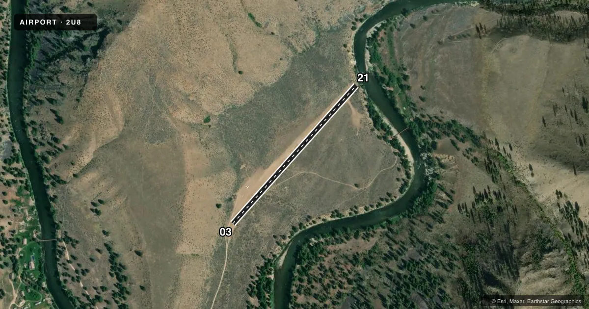
Airport sketch
Runways drawn to scale from FAA survey coordinates, rendered over satellite imagery. Not for navigation.
Approaches & charts
Services on the field
Fuel grades, oxygen, maintenance, ramp storage and lighting — as declared to the FAA by the airport operator.
Fuel & services
- Fuel
- Not available
- Oxygen (bottled)
- Not available
- Oxygen (bulk)
- Not available
- Airframe repair
- Not available
- Power plant repair
- Not available
Ramp & ground
- Transient storage
- Tie-down
- Landing fee
- No fee published
- Wind indicator
- Yes
- Segmented circle
- No
Fuel & FBOs
Cheapest 100LL and Jet A on the field and nearby. Always confirm with the FBO before taxi.
Airport notes
Surface conditions, obstructions, local procedures, lighting outages and other notes published with each FAA cycle.
General notes
- RCMD LNDG RY 21-TKOF RY 03; GO-AROUND EXTREMELY DIFICULT.
- NO WINTER MAINTENANCE.
- AIRCRAFT LOADING AND UNLOADING AT THE SOUTH END OF RY 21.
- RY 03 FIRST 400 FT IS DOG LEG WITH A HEADING OF 360 DEG.
- CONSIDERABLE AIR TAXI OPERATIONS MID TO LATE SUMMER.
- ARPT IS LCTD ON PLATEAU 100-150 FT ABOVE RIVER.
- FOR CD CTC SALT LAKE ARTCC AT 801-320-2568.
Runway surface & condition
- 03/21USBL WIDTH MAY VARY FM 75 FT TO 100 FT.
Approach & departure obstructions
- 03+100' RIDGE 250' ON CNTRLN.
- 21NUMEROUS TALL TREES ALONG RIVER ON APCH TO RY 21.
Other notes
- ESTABD PRIOR TO 12/31/58.
VFR map & nearby airports
VFR sectional. Tap any ICAO chip to open that airport.
Key facts · 2U8
Answer card- ICAO
- 2U8
- Name
- THOMAS CREEK
- Location
- STANLEY, IDAHO
- Elevation
- 4,415 ft MSL
- Traffic pattern altitude
- 5,415 ft MSL (1,000 AGL)
- Control tower
- Non-towered (use CTAF)
- Total runways
- 1
- Longest runway
- 03/21 · 2,100 ft
- Published ILS approaches
- 0
- Published frequencies
- 1
- Magnetic variation
- 17°
- Current flight rules
- VFR
- Current wind
- 000° at 5 kt
- Favored runway now
- RWY 03
Thomas Creek Airport (2U8) sits near Stanley, Idaho at 4,415 ft MSL. It has one runway. Runway 03/21 is 2,100 ft long with a turf-dirt surface. The airport is not towered. CTAF is 122.9. No ILS approaches are published here.
Pattern altitude is not published. Use the standard 1,000 ft AGL pattern unless the current Chart Supplement says otherwise. That puts the light-piston pattern at about 5,415 ft MSL. The field sits on a plateau 100 to 150 feet above the river. That matters on arrival and departure. The published remarks also call out numerous tall trees along the river on final to runway 21. Runway 03 has a dog leg for the first 400 feet with a heading of 360 degrees. A 100-foot ridge sits 250 feet on the centerline at the runway 03 end. Go-around is described as extremely difficult. No winter maintenance is provided.
There are no on-field FBOs listed. Check with the airport operator or the FBO directly by phone before you go. Mid to late summer can bring considerable air taxi traffic. For clearance delivery, contact Salt Lake ARTCC at 801-320-2568. Aircraft loading and unloading occurs at the south end of runway 21. Plan this field with care. It is a short turf strip at elevation with terrain and obstacle issues on both ends.