METAR & TAF S81
S81 does not publish a METAR.
Showing the nearest reporting station: KLLJ (CHALLIS) · 40.6 NM away. Conditions at S81 may differ.
METAR · KLLJ
Observed 04:55Z
KLLJ 270455Z AUTO 28005KT 10SM CLR 23/03 A3007 RMK AO2 SLP112 T02280028 $
- Wind
- 280° @ 5 kt
- Visibility
- 10 SM
- Temp / Dew
- 23°C / 3°C
- Altimeter
- 30.07 inHg
- Clouds
- CLR
- Density alt
- 6,624 ft
- Ceiling
- Unlimited
- Rules
- VFR
Airport info & contacts
Manager on record, flight service, ARTCC, attendance schedule and pattern altitude — published by the FAA and refreshed every 28 days.
Location
- From city
- 0 NM NE
- VFR sectional
- GREAT FALLS
- ARTCC
- ZLC · SALT LAKE CITY
- NOTAM facility
- BOI (NOTAM-D)
Airport manager
- Name
- MIDDLE FORK DIST RANGER
- Phone
- (208) 879-4102
- Address
- HC 63 BOX 1669, CHALLIS ID 83226
Flight service · Hours
- FSS BOI
- BOISE1-800-WX-BRIEF
- Attendance
- Unattended
Frequencies
Tap any row to copy the frequency to your clipboard.
Runways & pattern
Full pagePattern entry · RWY 22
LEFT TRAFFICRunway end performance
| End | TORA | TODA | ASDA | LDA | VGSI | Approach lights | Obstruction |
|---|---|---|---|---|---|---|---|
| 04 | — | — | — | — | — | — | 130', tree, 25' from thr, 90' R of cntrln, slope 0 |
| 22 | — | — | — | — | — | — | 75', tree, 0' from thr, 100' R of cntrln, slope 0 |
Declared distances in feet. TORA = takeoff run available, TODA = takeoff distance, ASDA = accelerate-stop, LDA = landing distance.
Airport sketch
Runways drawn to scale from FAA survey coordinates, rendered over satellite imagery. Not for navigation.
Approaches & charts
Services on the field
Fuel grades, oxygen, maintenance, ramp storage and lighting — as declared to the FAA by the airport operator.
Fuel & services
- Fuel
- Not available
- Oxygen (bottled)
- Not available
- Oxygen (bulk)
- Not available
- Airframe repair
- Not available
- Power plant repair
- Not available
Ramp & ground
- Transient storage
- Tie-down
- Landing fee
- No fee published
- Wind indicator
- Yes
- Segmented circle
- Yes
Fuel & FBOs
Cheapest 100LL and Jet A on the field and nearby. Always confirm with the FBO before taxi.
Airport notes
Surface conditions, obstructions, local procedures, lighting outages and other notes published with each FAA cycle.
General notes
- NO WINTER MAINT.
- BE ADVISED USFS RECMDS: WHEN DEPG UP OR DOWN STREAM REMAIN IN MAIN CANYON. DO NOT ATMT TO CLB OUT SIDE CANYONS.
- TFC OBSNC VCY OF PISTOL CREEK ARPT LCTD 2.5 MILES UPSTREAM.
- FOR CD CTC SALT LAKE ARTCC AT 801-320-2568.
Runway surface & condition
- 04/2230 FT USBL WID, RWY EDGE MKRS ARE 60 FT APART.
Approach & departure obstructions
- 04HAS +12 FT FENCE & TRRN 0 FT 60 FT LEFT; NMRS TREES TO 100 FT ON LEFT HALF OF APCH; +70 FT TREES 600 FT ON CNTRLN.
- 22390 FT SWY DIST PASSED THE BDRY MKRS. RIGHT HALF OF APCH BLOCKED BY 200 FT TIMBERED RIDGE 2000 FT ON CNTRLN.
- 04RWY 04/22 EDGES & THRS MKD WITH W ROCKS; EDGE MKRS ARE 60 FT APART.
- 04SRNDD BY 40 - 70 FT TALL TREES IN CLOSE PROXIMITY TO THE BDRY MKRS.
- 22RQRS A BIT OF A LEFT TURN/DOG LEG ON FINAL APCH DUE TO 70 - 100 FT TALL TREES CLOSE TO THE CNTRLN OF RWY.
Other notes
- ESTABD PRIOR TO 1959.
VFR map & nearby airports
VFR sectional. Tap any ICAO chip to open that airport.
Key facts · S81
Answer card- ICAO
- S81
- Name
- INDIAN CREEK USFS
- Location
- INDIAN CREEK, IDAHO
- Elevation
- 4,718 ft MSL
- Traffic pattern altitude
- 5,718 ft MSL (1,000 AGL)
- Control tower
- Non-towered (use CTAF)
- Total runways
- 1
- Longest runway
- 04/22 · 4,650 ft
- Published ILS approaches
- 0
- Published frequencies
- 1
- Magnetic variation
- 17°
- Current flight rules
- VFR
- Current wind
- 280° at 5 kt
- Favored runway now
- RWY 22
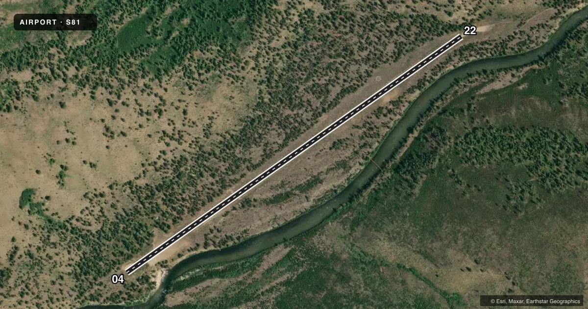
Indian Creek USFS sits in Indian Creek, Idaho. The field elevation is 4,718 ft MSL. It has one runway, 04/22, which is 4,650 ft long and dirt. There is no control tower. CTAF is 122.9. No ILS approaches are published.
Pattern altitude is not published. Use the standard 1,000 ft AGL pattern unless the current FAA Chart Supplement says otherwise. That puts the light piston pattern at 5,718 ft MSL. The airport has no on-field FBOs listed. Plan on self-sufficiency for fuel, services and ground support.
The published remarks matter here. There is no winter maintenance. Trees are close to both ends of the runway. Runway 04 has a fence near the approach and more trees on the left side. Runway 22 has a dogleg on final because of tall trees near the centerline. The Forest Service also advises staying in the main canyon when departing up or down stream. Do not try to climb outside the canyon. Clearance delivery is handled through Salt Lake ARTCC. This is a high-elevation backcountry strip with terrain and obstruction issues. Get current conditions before you go. Check the current FAA Chart Supplement for any updated remarks or restrictions before flying in.