METAR & TAF 0U3
0U3 does not publish a METAR.
Showing the nearest reporting station: KLLJ (CHALLIS) · 32.9 NM away. Conditions at 0U3 may differ.
METAR · KLLJ
Observed 10:55Z
KLLJ 271055Z AUTO 21003KT 10SM OVC060 14/03 A3012 RMK AO2 SLP121 T01440033 $
- Wind
- 210° @ 3 kt
- Visibility
- 10 SM
- Temp / Dew
- 14°C / 3°C
- Altimeter
- 30.12 inHg
- Clouds
- OVC
- Density alt
- 5,358 ft
- Ceiling
- 6,000 ft AGL
- Rules
- VFR
Airport info & contacts
Manager on record, flight service, ARTCC, attendance schedule and pattern altitude — published by the FAA and refreshed every 28 days.
Location
- From city
- 2 NM SE
- VFR sectional
- GREAT FALLS
- ARTCC
- ZLC · SALT LAKE CITY
- NOTAM facility
- BOI (NOTAM-D)
Airport manager
- Name
- MIDDLE FORK DIST RANGER
- Phone
- 208-879-4106
- Address
- 1206 S. CHALLIS ST, SALMON ID 83467
Flight service · Hours
- FSS BOI
- BOISE1-800-WX-BRIEF
- Attendance
- Unattended
Frequencies
Tap any row to copy the frequency to your clipboard.
Runways & pattern
Full pagePattern entry · RWY 22
LEFT TRAFFICRunway end performance
| End | TORA | TODA | ASDA | LDA | VGSI | Approach lights | Obstruction |
|---|---|---|---|---|---|---|---|
| 04 | — | — | — | — | — | — | 600', hill, 3000' from thr, 425' R of cntrln, slope 5 |
| 22 | — | — | — | — | — | — | 285', hill, 1900' from thr, 200' R of cntrln, slope 6 |
Declared distances in feet. TORA = takeoff run available, TODA = takeoff distance, ASDA = accelerate-stop, LDA = landing distance.
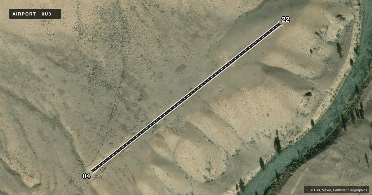
Airport sketch
Runways drawn to scale from FAA survey coordinates, rendered over satellite imagery. Not for navigation.
Approaches & charts
Services on the field
Fuel grades, oxygen, maintenance, ramp storage and lighting — as declared to the FAA by the airport operator.
Fuel & services
- Fuel
- Not available
- Oxygen (bottled)
- Not available
- Oxygen (bulk)
- Not available
- Airframe repair
- Not available
- Power plant repair
- Not available
Ramp & ground
- Transient storage
- Tie-down
- Landing fee
- No fee published
- Wind indicator
- Yes
- Segmented circle
- Yes
Fuel & FBOs
Cheapest 100LL and Jet A on the field and nearby. Always confirm with the FBO before taxi.
Airport notes
Surface conditions, obstructions, local procedures, lighting outages and other notes published with each FAA cycle.
General notes
- NO WINTER MAINT.
- RCMD LNDG RWY 22; TKOF RWY 04 WHEN WIND COND ALLOW.
- FOR CD CTC SALT LAKE ARTCC AT 801-320-2568.
Approach & departure obstructions
- 22-1 FT DITCH LCTD ALG BOTH EDGES OF RWY. FIRST 400 FT HAS 8 FT X 10 FT X 2 FT DEEP ELK WALLOWS OUTSIDE THE BDRY MKRS BOTH SIDES OF RWY.
- 04RWY 04/22 THRS & EDGES HAVE W WOOD PANELS BDRY MKRS; EDGE MKRS SET AT 60 FT WIDE.
- 22+180 FT RIDGE AT 1900 FT ON CNTRLN.
Other notes
- ESTABD PRIOR TO 12/31/58.
VFR map & nearby airports
VFR sectional. Tap any ICAO chip to open that airport.
Key facts · 0U3
Answer card- ICAO
- 0U3
- Name
- MAHONEY CREEK USFS
- Location
- MAHONEY CREEK, IDAHO
- Elevation
- 4,618 ft MSL
- Traffic pattern altitude
- 5,618 ft MSL (1,000 AGL)
- Control tower
- Non-towered (use CTAF)
- Total runways
- 1
- Longest runway
- 04/22 · 2,150 ft
- Published ILS approaches
- 0
- Published frequencies
- 1
- Magnetic variation
- 17°
- Current flight rules
- VFR
- Current wind
- 210° at 3 kt
- Favored runway now
- RWY 22
MAHONEY CREEK USFS (0U3) sits at Mahoney Creek, Idaho. The field elevation is 4,618 ft MSL. It has one runway, 04/22, which is 2,150 ft long and dirt. There is no control tower. CTAF is 122.9. No ILS approaches are published.
Pattern altitude is not published. Use the standard 1,000 ft AGL for light piston operations unless the current Chart Supplement says otherwise. That puts the pattern at about 5,618 ft MSL. The airport is in mountain country. Density altitude will matter. Performance planning should be conservative.
Published remarks matter here. Runway 22 has a ridge on centerline about 1,900 ft out. There are ditch edges along runway 22. The first 400 ft also has elk wallows outside the boundary markers on both sides. White wood panels mark the runway thresholds and edges. No winter maintenance is provided. The recommended landing runway is 22. Use runway 04 for takeoff when wind allows. For clearance delivery, contact Salt Lake ARTCC at 801-320-2568.
There are no on-field FBOs listed. Plan to arrive self-sufficient. Check the current FAA Chart Supplement and contact the airport operator or the FBO directly by phone before departure if you need current field condition details.