METAR & TAF KSMN
Current METAR
Observed 12:56Z
KSMN 271256Z AUTO 00000KT 7SM CLR 12/08 A3011 RMK AO2 SLP156 T01220078
- Wind
- 000° @ 0 kt
- Visibility
- 7 SM
- Temp / Dew
- 12°C / 8°C
- Altimeter
- 30.11 inHg
- Clouds
- CLR
- Density alt
- 4,419 ft
- Ceiling
- Unlimited
- Rules
- VFR
Airport info & contacts
Manager on record, flight service, ARTCC, attendance schedule and pattern altitude — published by the FAA and refreshed every 28 days.
Location
- From city
- 4 NM S
- VFR sectional
- GREAT FALLS
- ARTCC
- ZLC · SALT LAKE CITY
- NOTAM facility
- SMN (NOTAM-D)
Airport manager
- Name
- CHARLES LAMOURE
- Phone
- 208-940-2171
- Address
- 206 COURTHOUSE DRIVE, SALMON ID 83467
Flight service · Hours
- FSS BOI
- BOISE1-800-WX-BRIEF
- Attendance
- 0800-1700
Frequencies
Tap any row to copy the frequency to your clipboard.
Runways & pattern
Full pagePattern entry · RWY 17
LEFT TRAFFICRunway end performance
| End | TORA | TODA | ASDA | LDA | VGSI | Approach lights | Obstruction |
|---|---|---|---|---|---|---|---|
| 17 | — | — | — | — | PAPI 4-box left(3.5°) | — | — |
Declared distances in feet. TORA = takeoff run available, TODA = takeoff distance, ASDA = accelerate-stop, LDA = landing distance.
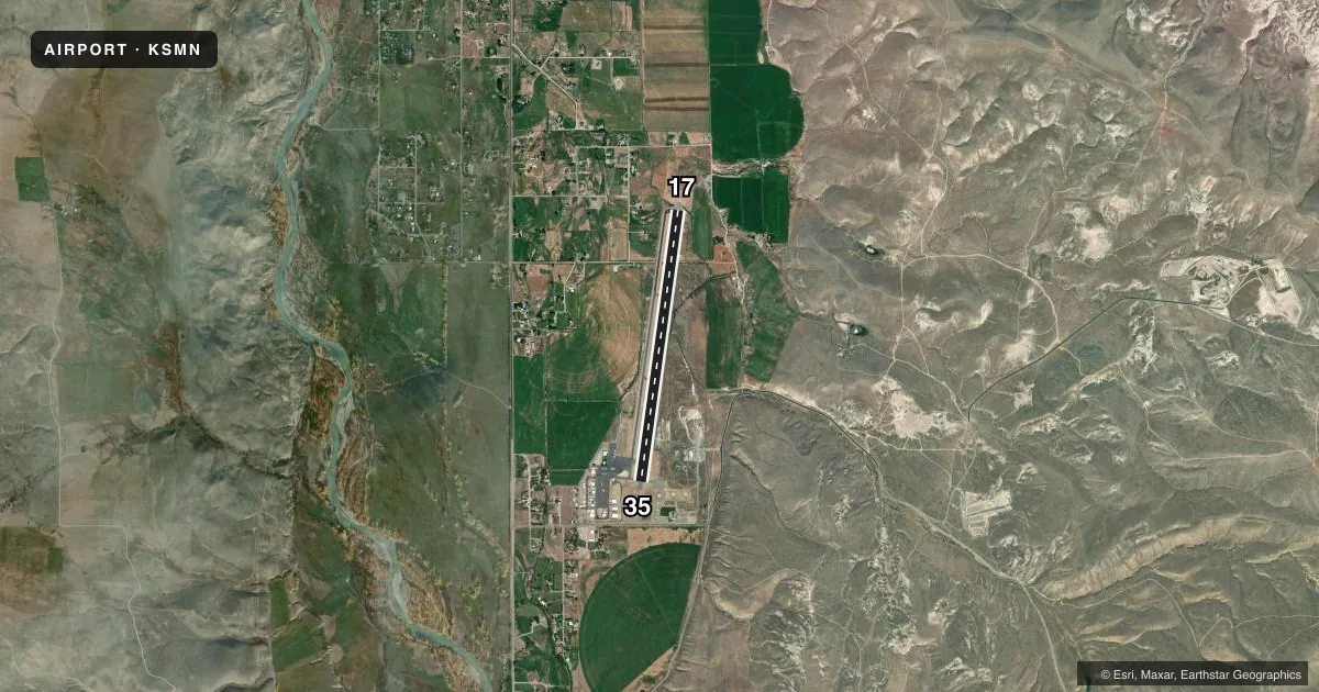
Airport sketch
Runways drawn to scale from FAA survey coordinates, rendered over satellite imagery. Not for navigation.
Approaches & charts
Services on the field
Fuel grades, oxygen, maintenance, ramp storage and lighting — as declared to the FAA by the airport operator.
Fuel & services
- Fuel
- 100A
- Oxygen (bottled)
- Not available
- Oxygen (bulk)
- Not available
- Airframe repair
- Major
- Power plant repair
- Major
- Other services
- CHTR,INSTR,RNTL
Ramp & ground
- Transient storage
- Tie-down
- Landing fee
- No fee published
- Customs
- Not available
- Lighting schedule
- SEE RMK
- Beacon schedule
- SS-SR
- Beacon
- White / Green (civil land)(WG)
- Wind indicator
- Lighted
- Segmented circle
- Yes
Fuel & FBOs
Cheapest 100LL and Jet A on the field and nearby. Always confirm with the FBO before taxi.
Airport notes
Surface conditions, obstructions, local procedures, lighting outages and other notes published with each FAA cycle.
General notes
- RETROREFLECTIVE REFLECTORS ON PARALLEL TWY AND RAMP AREA.
- TAXIWAY ACCESS TO AIRCRAFT RAMP LOCATED ON SE END OF AIRPORT IS CLSD.
- COLD TEMPERATURE AIRPORT. ALTITUDE CORRECTION REQUIRED AT OR BELOW -12C.
Lighting notes
- ACTVT MIRL RY 17/35; REIL RY 17 & RY 35 AND PAPI RY 17 - CTAF.
Approach & departure obstructions
- 17USE RGT TFC PATTERN FOR NIGHT OPNS ONLY.
- 35+1000' MOUNTAIN AT 3 MILES.
Other notes
- CONSTD PRIOR TO 1959.
VFR map & nearby airports
VFR sectional. Tap any ICAO chip to open that airport.
Key facts · KSMN
Answer card- ICAO
- KSMN
- Name
- LEMHI COUNTY
- Location
- SALMON, IDAHO
- Elevation
- 4,044.2 ft MSL
- Traffic pattern altitude
- 5,044.2 ft MSL (1,000 AGL)
- Control tower
- Non-towered (use CTAF)
- Total runways
- 1
- Longest runway
- 17/35 · 5,510 ft
- Published ILS approaches
- 0
- Published frequencies
- 2
- Magnetic variation
- 13°
- Current flight rules
- VFR
- Current wind
- 000° at 0 kt
- Favored runway now
- –
Lemhi County Airport sits near Salmon, Idaho. The field elevation is 4,044.2 ft MSL. It has one runway, 17/35, which is 5,510 ft long. There is no control tower. CTAF and UNICOM are both 122.8.
No ILS approaches are published here. Pattern altitude is not published, so use the standard 1,000 ft AGL for light piston operations unless the current FAA Chart Supplement says otherwise. The published remarks matter here. This is a cold temperature airport. Altitude correction is required at or below minus 12 degrees Celsius. Runway 17/35 has medium intensity lighting. Runway end identifier lights are installed on both ends. A PAPI is on runway 17. Use CTAF for lighting.
Three on-field FBOs are listed. Lemhi County Airport, McCall Aviation and Gem Air are all on the field. They carry 100LL, Jet A and Jet A Prist. The southeast ramp access is closed. There are retroreflective markers on the parallel taxiway and ramp area. Runway 35 has a mountain about 1,000 ft above airport elevation three miles out. Plan your departure and arrival with terrain in mind. Night ops use right traffic on runway 17/35 only.