METAR & TAF C53
C53 does not publish a METAR.
Showing the nearest reporting station: KLLJ (CHALLIS) · 30.5 NM away. Conditions at C53 may differ.
METAR · KLLJ
Observed 12:55Z
KLLJ 271255Z AUTO 00000KT 9SM CLR 14/03 A3014 RMK AO2 SLP134 T01390033 $
- Wind
- 000° @ 0 kt
- Visibility
- 9 SM
- Temp / Dew
- 14°C / 3°C
- Altimeter
- 30.14 inHg
- Clouds
- CLR
- Density alt
- 4,815 ft
- Ceiling
- Unlimited
- Rules
- VFR
Airport info & contacts
Manager on record, flight service, ARTCC, attendance schedule and pattern altitude — published by the FAA and refreshed every 28 days.
Location
- From city
- 30 NM SW
- VFR sectional
- GREAT FALLS
- ARTCC
- ZLC · SALT LAKE CITY
- NOTAM facility
- BOI (NOTAM-D)
Airport manager
- Name
- TOM CURET
- Phone
- 208-756-2271
- Address
- PO BOX 25, BOISE ID 83707
Flight service · Hours
- FSS BOI
- BOISE1-800-WX-BRIEF
- Attendance
- Unattended
Frequencies
Tap any row to copy the frequency to your clipboard.
Runways & pattern
Full pagePattern entry · RWY 16
LEFT TRAFFICRunway end performance
| End | TORA | TODA | ASDA | LDA | VGSI | Approach lights | Obstruction |
|---|---|---|---|---|---|---|---|
| 16 | — | — | — | — | — | — | 50', tree, 160' from thr, 90' R of cntrln, slope 3 |
| 34 | — | — | — | — | — | — | 40', brush, 50' from thr, 75' R of cntrln, slope 1 |
Declared distances in feet. TORA = takeoff run available, TODA = takeoff distance, ASDA = accelerate-stop, LDA = landing distance.
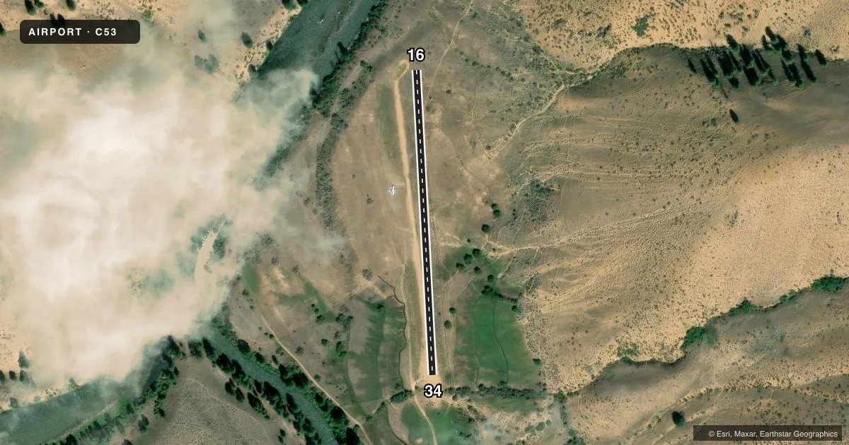
Airport sketch
Runways drawn to scale from FAA survey coordinates, rendered over satellite imagery. Not for navigation.
Approaches & charts
Services on the field
Fuel grades, oxygen, maintenance, ramp storage and lighting — as declared to the FAA by the airport operator.
Fuel & services
- Fuel
- Not available
- Oxygen (bottled)
- Not available
- Oxygen (bulk)
- Not available
- Airframe repair
- Not available
- Power plant repair
- Not available
Ramp & ground
- Transient storage
- Tie-down
- Wind indicator
- Yes
- Segmented circle
- No
Fuel & FBOs
Cheapest 100LL and Jet A on the field and nearby. Always confirm with the FBO before taxi.
Airport notes
Surface conditions, obstructions, local procedures, lighting outages and other notes published with each FAA cycle.
General notes
- ARPT LCTD ON A PLATEAU 50 FT TO 75 FT ABOVE THE RIVER.
- RY NOT MARKED.
- RECOMMEND LAND RY 16; DEPART RY 34 WHEN WIND CONDITIONS ALLOW.
- NO WINTER MAINT.
- STOCK AND BIG GAME ANIMALS INVOF RY.
- RODENT ACTIVITY ADJACENT BOTH SIDES OF RY.
- LCTD IN NARROW WINDING RIVER CANYON.
- FOR CD CTC SALT LAKE ARTCC AT 801-320-2568.
Other notes
- PROVIDED VFR OPS.
- 1 SET OF TIE DOWNS
VFR map & nearby airports
VFR sectional. Tap any ICAO chip to open that airport.
Key facts · C53
Answer card- ICAO
- C53
- Name
- LOWER LOON CREEK
- Location
- CHALLIS, IDAHO
- Elevation
- 4,200 ft MSL
- Traffic pattern altitude
- 5,200 ft MSL (1,000 AGL)
- Control tower
- Non-towered (use CTAF)
- Total runways
- 1
- Longest runway
- 16/34 · 1,200 ft
- Published ILS approaches
- 0
- Published frequencies
- 1
- Magnetic variation
- 17°
- Current flight rules
- VFR
- Current wind
- 000° at 0 kt
- Favored runway now
- –
Lower Loon Creek is in Challis, Idaho. The field elevation is 4,200 ft MSL. It has one runway, 16/34, at 1,200 ft on turf-dirt. The airport is not towered. CTAF is 122.9. No ILS approaches are published.
Pattern altitude is not published. For light piston planning, use 1,000 ft AGL unless the current Chart Supplement says otherwise. The airport sits on a plateau 50 to 75 feet above the river. It is in a narrow winding river canyon. That makes arrival planning important, especially with terrain, wind and density altitude.
Published remarks also say runway 16 is the preferred landing runway when wind allows. Runway 34 is the preferred departure runway when wind allows. The runway is not marked. No winter maintenance is provided. Stock and big game animals are in the area. Rodent activity is present beside both sides of the runway. One set of tie-downs is available.
There are no on-field FBOs listed. Check with the airport operator or the FBO directly by phone before arrival if you need current services. For clearance delivery, contact Salt Lake ARTCC at 801-320-2568. This is a VFR field. Plan conservatively. Verify current conditions before you go.