METAR & TAF KLLJ
Current METAR
Observed 12:55Z
KLLJ 271255Z AUTO 00000KT 9SM CLR 14/03 A3014 RMK AO2 SLP134 T01390033 $
- Wind
- 000° @ 0 kt
- Visibility
- 9 SM
- Temp / Dew
- 14°C / 3°C
- Altimeter
- 30.14 inHg
- Clouds
- CLR
- Density alt
- 5,901 ft
- Ceiling
- Unlimited
- Rules
- VFR
Airport info & contacts
Manager on record, flight service, ARTCC, attendance schedule and pattern altitude — published by the FAA and refreshed every 28 days.
Location
- From city
- 1 NM NE
- VFR sectional
- GREAT FALLS
- ARTCC
- ZLC · SALT LAKE CITY
- NOTAM facility
- LLJ (NOTAM-D)
Airport manager
- Name
- CAMERON DAVIS
- Phone
- (208) 833-4617
- Address
- PO BOX 587, CHALLIS ID 83226
Flight service · Hours
- FSS BOI
- BOISE1-800-WX-BRIEF
- Attendance
- MON-FRI · 0700-1700
Frequencies
Tap any row to copy the frequency to your clipboard.
Runways & pattern
Full pagePattern entry · RWY 17
LEFT TRAFFICRunway end performance
| End | TORA | TODA | ASDA | LDA | VGSI | Approach lights | Obstruction |
|---|---|---|---|---|---|---|---|
| 17 | — | — | — | — | PAPI 2-box left(4°) | — | — |
| 35 | — | — | — | — | — | — | 40', pline, 1450' from thr, 0' R of cntrln, slope 31 |
Declared distances in feet. TORA = takeoff run available, TODA = takeoff distance, ASDA = accelerate-stop, LDA = landing distance.
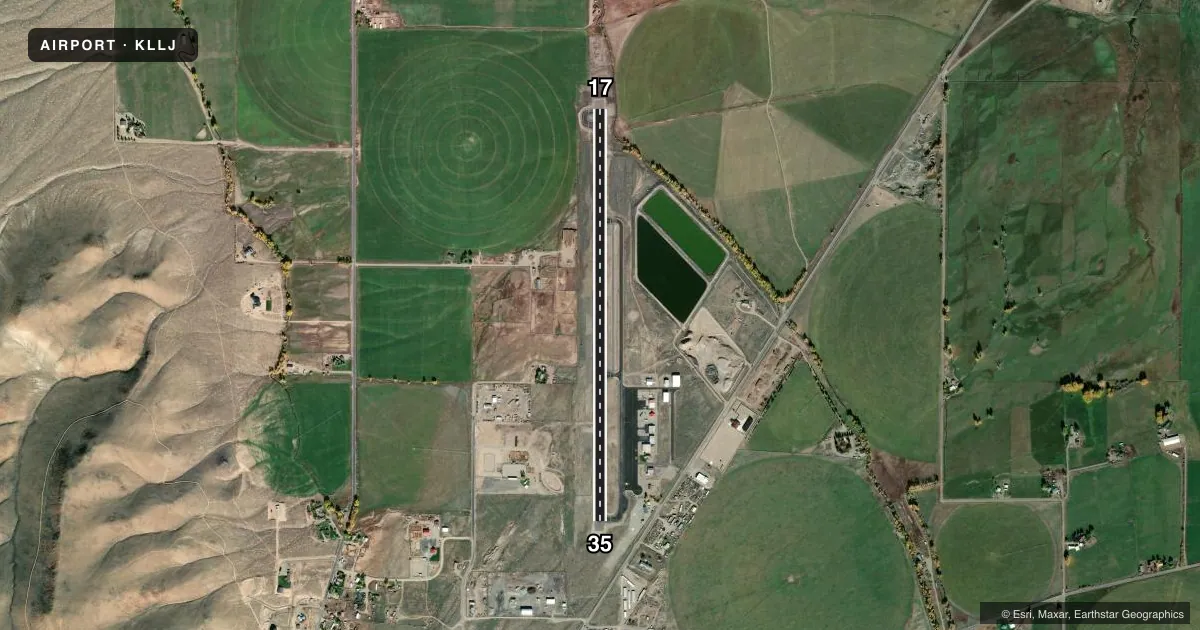
Airport sketch
Runways drawn to scale from FAA survey coordinates, rendered over satellite imagery. Not for navigation.
Approaches & charts
Services on the field
Fuel grades, oxygen, maintenance, ramp storage and lighting — as declared to the FAA by the airport operator.
Fuel & services
- Fuel
- 100A
- Oxygen (bottled)
- Not available
- Airframe repair
- Major
- Power plant repair
- Major
- Other services
- CHTR,INSTR
Ramp & ground
- Transient storage
- Tie-down
- Landing fee
- No fee published
- Customs
- Not available
- Lighting schedule
- SS-SR
- Beacon schedule
- SS-SR
- Beacon
- White / Green (civil land)(WG)
- Wind indicator
- Lighted
- Segmented circle
- Yes
Fuel & FBOs
Cheapest 100LL and Jet A on the field and nearby. Always confirm with the FBO before taxi.
Airport notes
Surface conditions, obstructions, local procedures, lighting outages and other notes published with each FAA cycle.
General notes
- BE ALERT HELICOPTER OPNS ADJACENT SOUTHEAST END OF ARPT.
- ASOS WX STN ON ARPT.
- ARPT LCTD IN HIGH MTN VALLEY.
- DEER ON & INVOF ARPT.
- RWY 17/35 RECOMMEND LAND RWY 17; TKOF RWY 35 WHEN WND CONDITIONS PERMIT.
- FOR CD CTC SALT LAKE ARTCC AT 801-320-2568.
Approach & departure obstructions
- 17RWY 17 PAPI UNUSBL BYD 7 DEGS RIGHT & LEFT OF CNTRLN: RWY 17 PAPI UNUSBL BYD 2.5 NM FM THR DUE TO TRRN.
Other notes
- ESTABD PRIOR TO 1959.
VFR map & nearby airports
VFR sectional. Tap any ICAO chip to open that airport.
Key facts · KLLJ
Answer card- ICAO
- KLLJ
- Name
- CHALLIS
- Location
- CHALLIS, IDAHO
- Elevation
- 5,075.9 ft MSL
- Traffic pattern altitude
- 6,075.9 ft MSL (1,000 AGL)
- Control tower
- Non-towered (use CTAF)
- Total runways
- 1
- Longest runway
- 17/35 · 4,601 ft
- Published ILS approaches
- 0
- Published frequencies
- 2
- Magnetic variation
- 12°
- Current flight rules
- VFR
- Current wind
- 000° at 0 kt
- Favored runway now
- –
Challis Airport sits in Challis, Idaho in a high mountain valley. Field elevation is 5,075.9 ft MSL. The airport has one runway, 17/35, which is 4,601 ft long with an asphalt surface. No tower is published. CTAF and UNICOM are both 122.8.
No ILS approaches are published for KLLJ. Pattern altitude is not published, so use the standard 1,000 ft AGL for light piston operations unless current published data says otherwise. Middle Fork Aviation is on the field. It carries 100LL and Jet A. Call them at (208) 879-5728 for current service details.
The Chart Supplement remarks matter here. Deer are on and near the airport. Helicopter traffic can be active near the southeast end. The airport also has an automated weather station on site. Runway 17 is the recommended landing runway when wind permits. Runway 35 is the recommended departure runway when wind permits. Runway 17 PAPI has limits near the edges of centerline. It also becomes unusable beyond 2.5 NM from the threshold because of terrain. That terrain note is worth a close read before a first arrival. Clearance delivery is handled through Salt Lake ARTCC at 801-320-2568.