METAR & TAF U61
U61 does not publish a METAR.
Showing the nearest reporting station: KSUN (FRIEDMAN MEML) · 27.6 NM away. Conditions at U61 may differ.
METAR · KSUN
Observed 12:50Z
KSUN 271250Z AUTO 32008KT 10SM OVC043 15/02 A3016 RMK AO2
- Wind
- 320° @ 8 kt
- Visibility
- 10 SM
- Temp / Dew
- 15°C / 2°C
- Altimeter
- 30.16 inHg
- Clouds
- OVC
- Density alt
- 8,258 ft
- Ceiling
- 4,300 ft AGL
- Rules
- VFR
Airport info & contacts
Manager on record, flight service, ARTCC, attendance schedule and pattern altitude — published by the FAA and refreshed every 28 days.
Location
- From city
- 22 NM NE
- VFR sectional
- SALT LAKE CITY
- ARTCC
- ZLC · SALT LAKE CITY
- NOTAM facility
- BOI (NOTAM-D)
Airport manager
- Name
- IDAHO STATE - ITD/DIV OF AERONAUTI
- Phone
- 208-334-8775
- Address
- P.O. BOX 7129, BOISE ID 83707-1129
Flight service · Hours
- FSS BOI
- BOISE1-800-WX-BRIEF
- Attendance
- Unattended
Frequencies
Tap any row to copy the frequency to your clipboard.
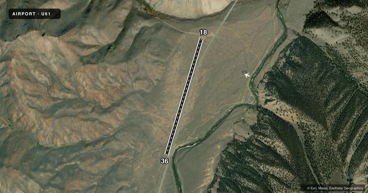
Runways & pattern
Full pagePattern entry · RWY 36
LEFT TRAFFICRunway end performance
| End | TORA | TODA | ASDA | LDA | VGSI | Approach lights | Obstruction |
|---|---|---|---|---|---|---|---|
| 18 | — | — | — | — | — | — | 500', hill, 1300' from thr, 0' R of cntrln, slope 2 |
| 36 | — | — | — | — | — | — | 2', berm, 0' from thr, 65' R of cntrln, slope 0 |
Declared distances in feet. TORA = takeoff run available, TODA = takeoff distance, ASDA = accelerate-stop, LDA = landing distance.
Airport sketch
Runways drawn to scale from FAA survey coordinates, rendered over satellite imagery. Not for navigation.
Approaches & charts
Services on the field
Fuel grades, oxygen, maintenance, ramp storage and lighting — as declared to the FAA by the airport operator.
Fuel & services
- Fuel
- Not available
- Oxygen (bottled)
- Not available
- Oxygen (bulk)
- Not available
- Airframe repair
- Not available
- Power plant repair
- Not available
Ramp & ground
- Transient storage
- Tie-down
- Landing fee
- No fee published
- Wind indicator
- Yes
- Segmented circle
- Yes
Fuel & FBOs
Cheapest 100LL and Jet A on the field and nearby. Always confirm with the FBO before taxi.
Airport notes
Surface conditions, obstructions, local procedures, lighting outages and other notes published with each FAA cycle.
General notes
- NO WINTER MAINT.
- ARPT LCTD IN HIGH MTN VALLEY SURROUNDED BY HIGH MTNS.
- BE ALERT ARPT SUBJECT TO ONGOING DAMAGE BY LIVESTOCK; GROUND VEHICLES AND RODENTS.
- RY 18/36 -1 FT DITCH & +1 FT - 2 FT DIRT BERM ENTIRE PERIMETER OF RY.
- FOR CD CTC SALT LAKE ARTCC AT 801-320-2568.
- SUG: LND RWY 36 AND TKOF RWY 18 IF WX COND PERMIT.
Approach & departure obstructions
- 18RY 18/36 EDGES & THLDS MARKED WITH WHITE ROCKS.
- 18ADDNL OBSTN +500 MTN 1300 FT FM THR ON CNTRLN; 14 FT ROAD 100 FT FM THR ON CNTRLN.
Other notes
- ESTABD PRIOR TO 3/31/59.
VFR map & nearby airports
VFR sectional. Tap any ICAO chip to open that airport.
Key facts · U61
Answer card- ICAO
- U61
- Name
- TWIN BRIDGES
- Location
- KETCHUM, IDAHO
- Elevation
- 6,900 ft MSL
- Traffic pattern altitude
- 7,900 ft MSL (1,000 AGL)
- Control tower
- Non-towered (use CTAF)
- Total runways
- 1
- Longest runway
- 18/36 · 4,450 ft
- Published ILS approaches
- 0
- Published frequencies
- 1
- Magnetic variation
- 17°
- Current flight rules
- VFR
- Current wind
- 320° at 8 kt
- Favored runway now
- RWY 36
Twin Bridges (U61) sits near Ketchum, Idaho in a high mountain valley surrounded by high terrain. Field elevation is 6,900 ft MSL. The airport has one runway. Runway 18/36 is 4,450 ft long and has turf-dirt surface. There is no control tower. CTAF is 122.9.
No ILS approaches are published here. Pattern altitude is not published, so use the standard 1,000 ft AGL for light piston operations unless the current FAA Chart Supplement says otherwise. The published remarks matter here. Runway edges and thresholds are marked with white rocks. There is a 1-foot ditch and a 1-foot to 2-foot dirt berm along the runway perimeter. The field is also subject to livestock, ground vehicle and rodent damage. There is no winter maintenance.
This is a mountain airport, so performance planning matters. Density altitude can be a real factor at this elevation. The published remarks also suggest landing runway 36 and taking off runway 18 if weather conditions permit. For clearance delivery, contact Salt Lake ARTCC at 801-320-2568. If you need current operational details before a trip, check the current FAA Chart Supplement or call the airport operator directly.