METAR & TAF U62
U62 does not publish a METAR.
Showing the nearest reporting station: KSUN (FRIEDMAN MEML) · 38.7 NM away. Conditions at U62 may differ.
METAR · KSUN
Observed 06:35Z
KSUN 270635Z AUTO 31007KT 10SM CLR 20/05 A3013 RMK AO2
- Wind
- 310° @ 7 kt
- Visibility
- 10 SM
- Temp / Dew
- 20°C / 5°C
- Altimeter
- 30.13 inHg
- Clouds
- CLR
- Density alt
- 7,646 ft
- Ceiling
- Unlimited
- Rules
- VFR
Airport info & contacts
Manager on record, flight service, ARTCC, attendance schedule and pattern altitude — published by the FAA and refreshed every 28 days.
Location
- From city
- 1 NM SE
- VFR sectional
- SALT LAKE CITY
- ARTCC
- ZLC · SALT LAKE CITY
- NOTAM facility
- BOI (NOTAM-D)
Airport manager
- Name
- MIKE FOSTER
- Phone
- 208-721-3450
- Address
- PO BOX 509, MACKAY ID 83251
Flight service · Hours
- FSS BOI
- BOISE1-800-WX-BRIEF
- Attendance
- Unattended
Frequencies
Tap any row to copy the frequency to your clipboard.
Runways & pattern
Full pagePattern entry · RWY 30
LEFT TRAFFICRunway end performance
| End | TORA | TODA | ASDA | LDA | VGSI | Approach lights | Obstruction |
|---|---|---|---|---|---|---|---|
| 12 | — | — | — | — | — | — | 35', pline, 200' from thr, 115' R of cntrln, slope 0 |
| 30 | — | — | — | — | — | — | 25', brush, 400' from thr, 0' R of cntrln, slope 8 |
Declared distances in feet. TORA = takeoff run available, TODA = takeoff distance, ASDA = accelerate-stop, LDA = landing distance.
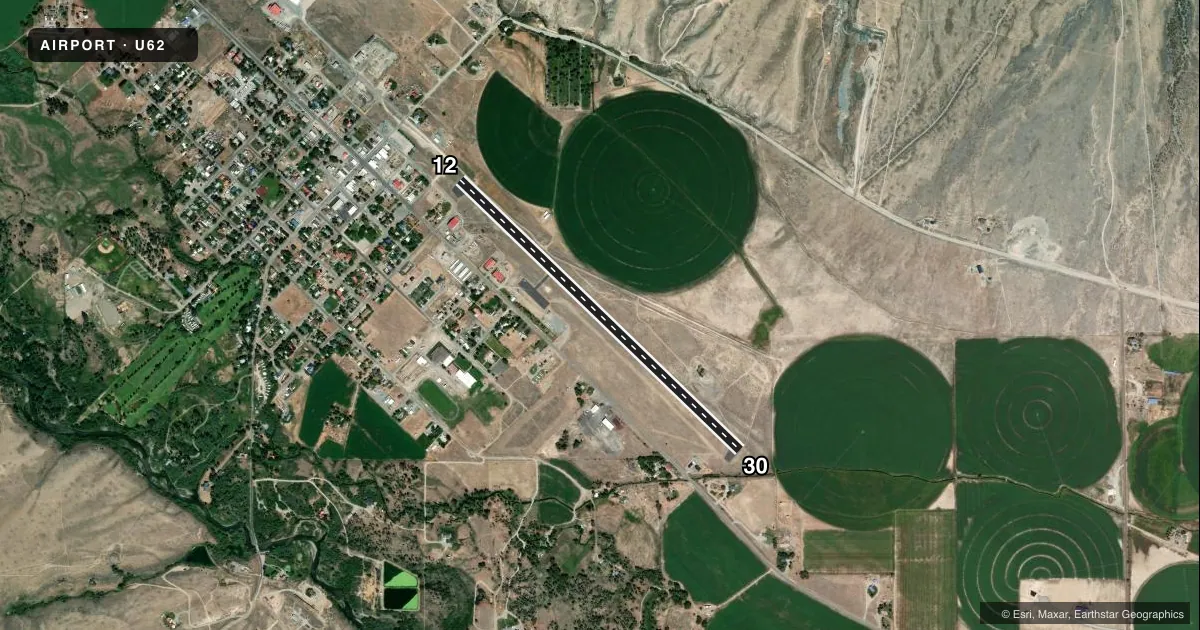
Airport sketch
Runways drawn to scale from FAA survey coordinates, rendered over satellite imagery. Not for navigation.
Approaches & charts
Services on the field
Fuel grades, oxygen, maintenance, ramp storage and lighting — as declared to the FAA by the airport operator.
Fuel & services
- Fuel
- Not available
Ramp & ground
- Transient storage
- Tie-down
- Landing fee
- No fee published
- Customs
- Not available
- Wind indicator
- Yes
- Segmented circle
- Yes
Fuel & FBOs
Cheapest 100LL and Jet A on the field and nearby. Always confirm with the FBO before taxi.
Airport notes
Surface conditions, obstructions, local procedures, lighting outages and other notes published with each FAA cycle.
General notes
- FOR CD CTC SALT LAKE ARTCC AT 801-320-2568.
- WINTER MAINT NA.
Runway surface & condition
- 12/30WINDS PMTG ARR RWY 30; DEP RWY 12.
- H1LCTD BTN RWY & PRKG AREA.
Approach & departure obstructions
- 12+35 FT PWR LINE AT RWY END 115 FT L.
- 12+35 FT PWR LINE MKD AT 1600 FT ON CNTRLN.
- 12RWY MARKINGS ARE SUB-STANDARD W/NRS. TOO SMALL IN SIZE AND A VERY CROOKED CTR LINE.
- 30RWY MARKINGS ARE SUB-STD W/NRS. TOO SML IN SIZE AND A VERY CROOKED CTR LINE.
Other notes
- 12/30RY 12/30 RWY. DISPLAYS VERY ROUGH CHIP SEAL WITH UNEVEN SFC IN PLACES.
VFR map & nearby airports
VFR sectional. Tap any ICAO chip to open that airport.
Key facts · U62
Answer card- ICAO
- U62
- Name
- MACKAY
- Location
- MACKAY, IDAHO
- Elevation
- 5,892 ft MSL
- Traffic pattern altitude
- 6,892 ft MSL (1,000 AGL)
- Control tower
- Non-towered (use CTAF)
- Total runways
- 1
- Longest runway
- 12/30 · 4,389 ft
- Published ILS approaches
- 0
- Published frequencies
- 1
- Magnetic variation
- 16°
- Current flight rules
- VFR
- Current wind
- 310° at 7 kt
- Favored runway now
- RWY 30
Mackay Airport sits in Mackay, Idaho. The field elevation is 5,892 ft MSL. It has one runway. Runway 12/30 is 4,389 ft long with an asphalt surface. There is no control tower. CTAF is 122.9. No ILS approaches are published here.
The published pattern altitude is not listed. Use the standard 1,000 ft AGL pattern for light piston operations unless the current Chart Supplement says otherwise. That puts the pattern at 6,892 ft MSL. The airport sits high enough that density altitude will matter on warm days. Performance planning should be conservative.
Published remarks call out rough chip seal and uneven surface on runway 12/30. They also note substandard runway markings on both ends. Runway 12 has a 35-foot power line 115 feet left of the runway end. Another 35-foot power line is marked 1,600 feet on the centerline of runway 12. Winds are said to arrive mostly on runway 30 and depart on runway 12. Winter maintenance is not available. There are no on-field FBOs listed, so plan to verify services with the airport operator or by calling the field before arrival. Heliport H1 is located between the runway and the parking area.