METAR & TAF KSUN
Current METAR
Observed 12:50Z
KSUN 271250Z AUTO 32008KT 10SM OVC043 15/02 A3016 RMK AO2
- Wind
- 320° @ 8 kt
- Visibility
- 10 SM
- Temp / Dew
- 15°C / 2°C
- Altimeter
- 30.16 inHg
- Clouds
- OVC
- Density alt
- 6,299 ft
- Ceiling
- 4,300 ft AGL
- Rules
- VFR
Airport info & contacts
Manager on record, flight service, ARTCC, attendance schedule and pattern altitude — published by the FAA and refreshed every 28 days.
Location
- From city
- 1 NM SE
- VFR sectional
- SALT LAKE CITY
- ARTCC
- ZLC · SALT LAKE CITY
- NOTAM facility
- SUN (NOTAM-D)
Airport manager
- Name
- TIM BURKE
- Phone
- 208-720-5186
- Address
- 1616 AIRPORT CIR, HAILEY ID 83333-5534
Flight service · Hours
- FSS BOI
- BOISE1-800-WX-BRIEF
- Attendance
- 0700-2300
Frequencies
Tap any row to copy the frequency to your clipboard.
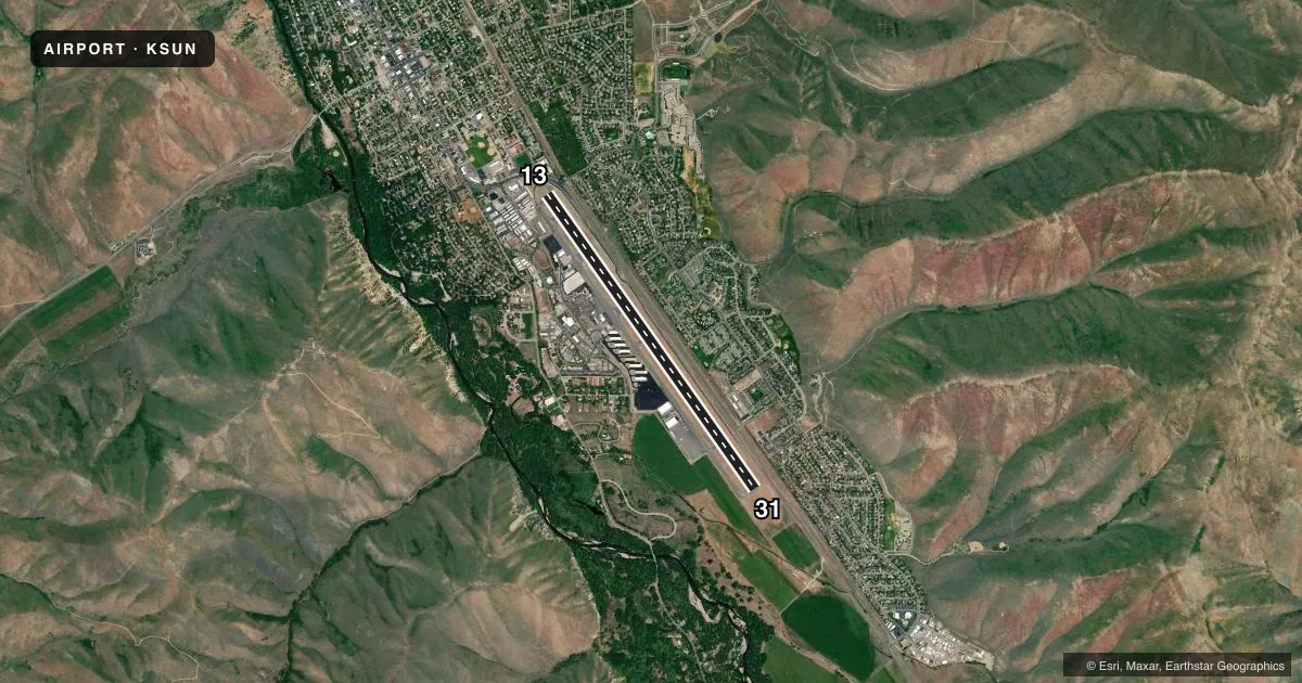
Runways & pattern
Full pagePattern entry · RWY 31
LEFT TRAFFICRunway end performance
| End | TORA | TODA | ASDA | LDA | VGSI | Approach lights | Obstruction |
|---|---|---|---|---|---|---|---|
| 13 | 7,550' | 7,550' | 7,550' | 5,850' | — | — | 17', road, 200' from thr, 190' R of cntrln, slope 0 |
| 31 | 5,850' | 7,550' | 6,631' | 6,631' | PAPI 4-box left(3.5°) | — | — |
Declared distances in feet. TORA = takeoff run available, TODA = takeoff distance, ASDA = accelerate-stop, LDA = landing distance.
Airport sketch
Runways drawn to scale from FAA survey coordinates, rendered over satellite imagery. Not for navigation.
Approaches & charts
Services on the field
Fuel grades, oxygen, maintenance, ramp storage and lighting — as declared to the FAA by the airport operator.
Fuel & services
- Fuel
- 100LLA1+
- Oxygen (bottled)
- High pressure
- Oxygen (bulk)
- High pressure
- Airframe repair
- Major
- Power plant repair
- Major
- Other services
- AFRT,AMB,CARGO,CHTR,INSTR,RNTL,SALES
Ramp & ground
- Transient storage
- Tie-down
- Hangar
- Landing fee
- Yes
- Customs
- Not available
- Lighting schedule
- SEE RMK
- Beacon schedule
- SS-SR
- Beacon
- White / Green (civil land)(WG)
- Wind indicator
- Lighted
- Segmented circle
- No
Fuel & FBOs
Cheapest 100LL and Jet A on the field and nearby. Always confirm with the FBO before taxi.
Airport notes
Surface conditions, obstructions, local procedures, lighting outages and other notes published with each FAA cycle.
General notes
- MTUS TRRN; NIGHT USE & WHEN WX MARGINAL NOT RCMDD. BIRD INVOF RWY.
- APCH RWY 31 ALG E SIDE OF VALLEY; DEP RWY 13 ALG W SIDE OF VALLEY; WITH LNDG LGT ON; OPDT.
- LOCKED BRAKE TURNS NA.
- SFC COND UNMNT; ARFF UNAVBL 2300-0700.
- ACR LTD PRKG AVBL.
- RWY LTD TO 95000 LB OR LESS MAX TKOF WT. DUAL WHEEL WITH MAX TKOF WT GTR THAN 95000 LB 48 HR PPR - AMGR.
- APU OPS LTD TO 30 MI.
- TWY B5 & B6 RSTD TO WINGSPAN 79 FT OR LESS; DESIGN GROUP II ONLY.
- GA TSNT LESS THAN 40 FT WINGSPAN PRKG ON SECT 2 APN BLUE TIE DOWN SPOTS. TSNT PRKG - 208-788-9511.
- COLD TEMP ARPT. ALT COR RQRD AT OR BLO -13C.
- TSNT HEL OPS - 208-720-5186. ARPT OPS - 208-788-9511 FOR PRKG. DEDICATED HEL PRKG PADS NA.
- FOR CD IF UNA TO CTC ON FSS FREQ, CTC SALT LAKE ARTCC AT 801-320-2568.
- WHEN ATCT CLSD ARR ANNC ON 125.6 AT 20, 15, 10, 5 MI OUT & SHORT FNA. PAEW ON RWY.
- FUEL SVC AFT DUSK PPR - 208-788-9511.
- PPR FOR WINGSPAN GTR THAN 100 FT.
- ALL SFCS AVBL TO ACRS EXCP B5, B6.
- FLY QUIET VOLUNTARY CURFEW 2300-0700L. DEPART SOUTH. ARRIVE NORTH. CTC AMGR 208-720-5186 FOR NOISE ABATEMENT PROCS.
- HANG GLDRS, PARA GLDRS, & SKYDIVING ON & INVOF ARPT & CLASS D ASP UP TO 18000 FT MSL.
Lighting notes
- WHEN ATCT CLSD ACTVT HIRL RWY 13/31 - CTAF. PAPI RWY 31 OPR CONSLY.
Runway surface & condition
- 13/31PCR VALUE: 260/F/C/X/T
- 13/31WHEN ATCT CLSD LND RWY 31; TKOF RWY 13; OPDT IN PAT. ATCT 275 FT E OF CNTRLN.
Approach & departure obstructions
- 1317 FT RD 450 FT FM THR 250 FT LEFT; 15 FT PIPES 500 FT FM THR 180 FT RIGHT; 7 FT FENCE 550 FT FM THR 180 FT LEFT; 17 FT RD 550 FT FM THR 190 FT LEFT.
- 13ROAD 65:1 TO DTHR; PRKD ACFT 0-225 FT L 0:1 TO DTHR.
Other notes
- ESTABD PRIOR TO 1959.
- AVBL 0700-2300.
- PPR FOR SKED ACR OPS 2300-0600 - AMGR.
- LNDG FEE GTR THAN 6000 LB.
- OWNER208-788-5500.
VFR map & nearby airports
VFR sectional. Tap any ICAO chip to open that airport.
Key facts · KSUN
Answer card- ICAO
- KSUN
- Name
- FRIEDMAN MEML
- Location
- HAILEY, IDAHO
- Elevation
- 5,319.5 ft MSL
- Traffic pattern altitude
- 6,319.5 ft MSL (1,000 AGL)
- Control tower
- Towered · 0700-2300
- Total runways
- 1
- Longest runway
- 13/31 · 7,550 ft
- Published ILS approaches
- 0
- Published frequencies
- 5
- Magnetic variation
- 13°
- Current flight rules
- VFR
- Current wind
- 320° at 8 kt
- Favored runway now
- RWY 31
Friedman Meml Airport sits in Hailey, Idaho. The field elevation is 5,319.5 ft MSL. KSUN has one runway, 13/31, which is 7,550 ft long. The control tower is open from 0700 to 2300 local. No ILS approaches are published here.
Pattern altitude is not published. Use the standard 1,000 ft AGL for light piston traffic unless the current Chart Supplement says otherwise. Atlantic Aviation is on the field. It carries 100LL and Jet A. Call them at (208) 788-9511 for current services and transient parking. The airport also notes a landing fee for aircraft over 6,000 lb.
This is a mountain airport. The published remarks say night use and marginal weather operations are not recommended. The field also asks pilots to fly quiet. Depart south and arrive north when practical. Use landing lights. When the tower is closed, runway 13/31 lighting is activated on CTAF. The PAPI for runway 31 runs continuously. If you are new to the airport, pay close attention to the valley routing. Approach runway 31 along the east side of the valley. Depart runway 13 along the west side of the valley. Check the current Chart Supplement for any noise or curfew restrictions before flying in.