METAR & TAF U93
U93 does not publish a METAR.
Showing the nearest reporting station: KSUN (FRIEDMAN MEML) · 14.1 NM away. Conditions at U93 may differ.
METAR · KSUN
Observed 12:50Z
KSUN 271250Z AUTO 32008KT 10SM OVC043 15/02 A3016 RMK AO2
- Wind
- 320° @ 8 kt
- Visibility
- 10 SM
- Temp / Dew
- 15°C / 2°C
- Altimeter
- 30.16 inHg
- Clouds
- OVC
- Density alt
- 5,709 ft
- Ceiling
- 4,300 ft AGL
- Rules
- VFR
Airport info & contacts
Manager on record, flight service, ARTCC, attendance schedule and pattern altitude — published by the FAA and refreshed every 28 days.
Location
- From city
- 15 NM SW
- VFR sectional
- SALT LAKE CITY
- ARTCC
- ZLC · SALT LAKE CITY
- NOTAM facility
- BOI (NOTAM-D)
Airport manager
- Name
- IDAHO DIV OF AERONAUTICS
- Phone
- 208-334-8775
- Address
- P O BOX 7129, BOISE ID 83707-1129
Flight service · Hours
- FSS BOI
- BOISE1-800-WX-BRIEF
- Attendance
- Unattended
Frequencies
Tap any row to copy the frequency to your clipboard.
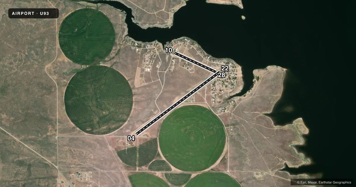
Runways & pattern
Full pagePattern entry · RWY 28
LEFT TRAFFIC| Runway | Heading (°M) | Length | Surface | Traffic |
|---|---|---|---|---|
| 04/22 | 37° / 217° | 4,000 ft | TURF-GRVL | Standard L |
| 10/28Favored | 99° / 279° | 1,750 ft | TURF-DIRT | Standard L |
Runway end performance
| End | TORA | TODA | ASDA | LDA | VGSI | Approach lights | Obstruction |
|---|---|---|---|---|---|---|---|
| 04 | — | — | — | — | — | — | 15', road, 0' from thr, 80' R of cntrln, slope 0 |
| 22 | — | — | — | — | — | — | 4', fence, 0' from thr, 80' R of cntrln, slope 0 |
| 10 | — | — | — | — | — | — | 4', sign, 50' from thr, 0' R of cntrln, slope 0 |
| 28 | — | — | — | — | — | — | 50', trees, 480' from thr, 0' R of cntrln, slope 9 |
Declared distances in feet. TORA = takeoff run available, TODA = takeoff distance, ASDA = accelerate-stop, LDA = landing distance.
Airport sketch
Runways drawn to scale from FAA survey coordinates, rendered over satellite imagery. Not for navigation.
Approaches & charts
Services on the field
Fuel grades, oxygen, maintenance, ramp storage and lighting — as declared to the FAA by the airport operator.
Fuel & services
- Fuel
- Not available
- Oxygen (bottled)
- Not available
- Oxygen (bulk)
- Not available
- Airframe repair
- Not available
- Power plant repair
- Not available
Ramp & ground
- Transient storage
- Tie-down
- Landing fee
- No fee published
- Customs
- Not available
- Wind indicator
- Yes
- Segmented circle
- Yes
Fuel & FBOs
Cheapest 100LL and Jet A on the field and nearby. Always confirm with the FBO before taxi.
Airport notes
Surface conditions, obstructions, local procedures, lighting outages and other notes published with each FAA cycle.
General notes
- NO TELEPHONE AVBL AT ARPT.
- NO WINTER MAINTENANCE.
- WHEN WIND CONDS ALLOW; LAND RWY 04 OR RWY 10; TKOF RWY 22 OR RWY 28 TO AVOID FLYING OVER RESORT AREA.
- RWY 10/28 NO LINE OF SIGHT BTN RWY ENDS.
- FOR CD CTC SALT LAKE ARTCC AT 801-320-2568.
Approach & departure obstructions
- 04EDGES & THLDS MARKED WITH WHITE ROCKS.
- 044 FT BARB WIRE FENCE AT 160 FT ON CNTRLN, 15 FT RD AT 175 FT ON CNTRLN.
- 104 FT BARB WIRE FENCE AT 50 FT ON CNTRLN. 18 FT TALL HOUSE BLW RWY GRADE AT 150 FT ON CNTRLN.
- 04ADDNL OBST; +10 FT RD AT 175 FT ON CNTRLN; +4 FT FENCE AT 160 FT ON CNTRLN.
- 22ADDNL OBST: NUMEROUS 30-50 FT TREES & BLDGS TO 30 FT ON APCH.
- 28ADDNL OBST NMRS 30-50 FT TREES & 15 FT BLDG ON APCH.
Other notes
- ESTABD PRIOR TO 1959.
- 10/28SFC COND IS SLGTLY ROUGH DUE TO CLUMP GRASS.
VFR map & nearby airports
VFR sectional. Tap any ICAO chip to open that airport.
Key facts · U93
Answer card- ICAO
- U93
- Name
- MAGIC RESERVOIR
- Location
- HAILEY, IDAHO
- Elevation
- 4,844 ft MSL
- Traffic pattern altitude
- 5,844 ft MSL (1,000 AGL)
- Control tower
- Non-towered (use CTAF)
- Total runways
- 2
- Longest runway
- 04/22 · 4,000 ft
- Published ILS approaches
- 0
- Published frequencies
- 1
- Magnetic variation
- 16°
- Current flight rules
- VFR
- Current wind
- 320° at 8 kt
- Favored runway now
- RWY 28
Magic Reservoir (U93) sits near Hailey, Idaho at 4,844 ft MSL. It has two runways. The longest is 4,000 ft on runway 04/22. The field is not towered. CTAF is 122.9. No ILS approaches are published. Pattern altitude is not published, so use the standard 1,000 ft AGL for light piston operations unless the current FAA Chart Supplement says otherwise.
This is a high-elevation field, so performance planning matters. The airport sits in mountain country. Expect density altitude to be a real factor in warm weather. Runway 10/28 is turf-dirt and is noted as slightly rough because of clump grass. Runway 04/22 is turf-grvl. Published remarks also call out obstacles on multiple approaches. Runway 04 has a fence and road close in on final. Runway 22 has trees and buildings on approach. Runway 28 also has trees and a building on approach. The Chart Supplement also notes that runway 10/28 has no line of sight between runway ends.
There are no on-field FBOs listed, so plan on self-sufficiency. No winter maintenance is provided. The airport remarks say that when wind allows, runway 04 or 10 is preferred for landing. Runway 22 or 28 is preferred for departure to avoid flying over the resort area. There is no telephone at the airport. For clearance delivery, contact Salt Lake ARTCC at 801-320-2568.