METAR & TAF U65
U65 does not publish a METAR.
Showing the nearest reporting station: KSUN (FRIEDMAN MEML) · 19.6 NM away. Conditions at U65 may differ.
METAR · KSUN
Observed 12:50Z
KSUN 271250Z AUTO 32008KT 10SM OVC043 15/02 A3016 RMK AO2
- Wind
- 320° @ 8 kt
- Visibility
- 10 SM
- Temp / Dew
- 15°C / 2°C
- Altimeter
- 30.16 inHg
- Clouds
- OVC
- Density alt
- 5,641 ft
- Ceiling
- 4,300 ft AGL
- Rules
- VFR
Airport info & contacts
Manager on record, flight service, ARTCC, attendance schedule and pattern altitude — published by the FAA and refreshed every 28 days.
Location
- From city
- 0 NM E
- VFR sectional
- SALT LAKE CITY
- ARTCC
- ZLC · SALT LAKE CITY
- NOTAM facility
- BOI (NOTAM-D)
Airport manager
- Name
- JOSH PRITCHARD
- Phone
- 208-721-2965
- Address
- 20 EL PINO, CAREY ID 83320
Flight service · Hours
- FSS BOI
- BOISE1-800-WX-BRIEF
- Attendance
- Unattended
Frequencies
Tap any row to copy the frequency to your clipboard.
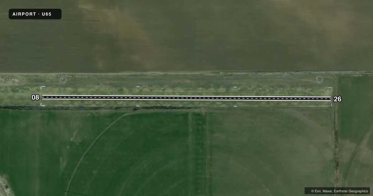
Runways & pattern
Full pagePattern entry · RWY 26
LEFT TRAFFICRunway end performance
| End | TORA | TODA | ASDA | LDA | VGSI | Approach lights | Obstruction |
|---|---|---|---|---|---|---|---|
| 08 | — | — | — | — | — | — | 6', fence, 0' from thr, 100' R of cntrln, slope 0 |
| 26 | — | — | — | — | — | — | 4', fence, 25' from thr, 0' R of cntrln, slope 6 |
Declared distances in feet. TORA = takeoff run available, TODA = takeoff distance, ASDA = accelerate-stop, LDA = landing distance.
Airport sketch
Runways drawn to scale from FAA survey coordinates, rendered over satellite imagery. Not for navigation.
Approaches & charts
Services on the field
Fuel grades, oxygen, maintenance, ramp storage and lighting — as declared to the FAA by the airport operator.
Fuel & services
- Fuel
- Not available
- Oxygen (bottled)
- Not available
- Oxygen (bulk)
- Not available
- Airframe repair
- Not available
- Power plant repair
- Not available
Ramp & ground
- Transient storage
- Tie-down
- Landing fee
- No fee published
- Customs
- Not available
- Wind indicator
- Lighted
- Segmented circle
- Yes
Fuel & FBOs
Cheapest 100LL and Jet A on the field and nearby. Always confirm with the FBO before taxi.
Airport notes
Surface conditions, obstructions, local procedures, lighting outages and other notes published with each FAA cycle.
General notes
- RECOMMEND LAND RWY 26; TKOF RWY 8 WHEN WND CONDITIONS PERMIT.
- 30 FT HNGR & NMRS 30 TO 80 FT TREES AT 900 FT TO 1200 FT FM EOR 08.
- BE ALERT FOR SPRINKLERS ON RY.
- FOR CD CTC SALT LAKE ARTCC AT 801-320-2568.
Approach & departure obstructions
- 0808/26 EDGES & THRS MKD WITH CONCRETE MARKERS.
- 08A 6 FT CHAIN LINK FENCE HAS BEEN INSTLD ON THE SOUTH SIDE OF RWY AT 0 FT, 100 FT RIGHT - BTN THE TIE-DOWN AREA AND THE AG FLD ADJ TO IT.
Other notes
- ESTABD PRIOR TO 1959.
- FULL CRC, NON-STD ON BOTH WINDSOCKS.
VFR map & nearby airports
VFR sectional. Tap any ICAO chip to open that airport.
Key facts · U65
Answer card- ICAO
- U65
- Name
- CAREY
- Location
- CAREY, IDAHO
- Elevation
- 4,789 ft MSL
- Traffic pattern altitude
- 5,789 ft MSL (1,000 AGL)
- Control tower
- Non-towered (use CTAF)
- Total runways
- 1
- Longest runway
- 08/26 · 2,650 ft
- Published ILS approaches
- 0
- Published frequencies
- 1
- Magnetic variation
- 16°
- Current flight rules
- VFR
- Current wind
- 320° at 8 kt
- Favored runway now
- RWY 26
Carey Airport (U65) is in Carey, Idaho. The field sits at 4,789 ft MSL. It has one runway. Runway 08/26 is 2,650 ft of turf, so plan for soft-field performance and watch your rollout. There is no control tower. CTAF is 122.9. No ILS approaches are published here.
Pattern altitude is not published. Use 1,000 ft AGL for light piston planning unless the current Chart Supplement says otherwise. The airport has a full segmented circle with non-standard windsocks on both sides. Published remarks also call out concrete runway edge and threshold markers. Be alert for sprinklers on the runway. There is a 30-foot hangar near the field. Trees 30 to 80 ft tall sit 900 to 1,200 ft from the end of runway 08. That makes the 08 end a place to stay sharp on climbout and landing path.
The published note recommends landing runway 26 and taking off runway 08 when wind conditions allow. That fits the terrain and obstacle picture here. No on-field FBOs are listed. Check the current FAA Chart Supplement or call the airport operator directly before you go if you need local services. For clearance delivery, contact Salt Lake ARTCC at 801-320-2568.