METAR & TAF U92
U92 does not publish a METAR.
Showing the nearest reporting station: KSUN (FRIEDMAN MEML) · 31.9 NM away. Conditions at U92 may differ.
METAR · KSUN
Observed 09:15Z
KSUN 270915Z AUTO 31011KT 10SM SCT055 18/02 A3013 RMK AO2
- Wind
- 310° @ 11 kt
- Visibility
- 10 SM
- Temp / Dew
- 18°C / 2°C
- Altimeter
- 30.13 inHg
- Clouds
- SCT
- Density alt
- 7,779 ft
- Ceiling
- Unlimited
- Rules
- VFR
Airport info & contacts
Manager on record, flight service, ARTCC, attendance schedule and pattern altitude — published by the FAA and refreshed every 28 days.
Location
- From city
- 12 NM SW
- VFR sectional
- SALT LAKE CITY
- ARTCC
- ZLC · SALT LAKE CITY
- NOTAM facility
- BOI (NOTAM-D)
Airport manager
- Name
- DIV ADMIN
- Phone
- 208-334-8775
- Address
- P O BOX 7129, BOISE ID 83707-1129
Flight service · Hours
- FSS BOI
- BOISE1-800-WX-BRIEF
- Attendance
- Unattended
Frequencies
Tap any row to copy the frequency to your clipboard.
Runways & pattern
Full pagePattern entry · RWY 25
LEFT TRAFFICRunway end performance
| End | TORA | TODA | ASDA | LDA | VGSI | Approach lights | Obstruction |
|---|---|---|---|---|---|---|---|
| 07 | — | — | — | — | — | — | 15', road, 0' from thr, 120' R of cntrln, slope 0 |
| 25 | — | — | — | — | — | — | 30', pline, 370' from thr, 0' R of cntrln, slope 12 |
Declared distances in feet. TORA = takeoff run available, TODA = takeoff distance, ASDA = accelerate-stop, LDA = landing distance.
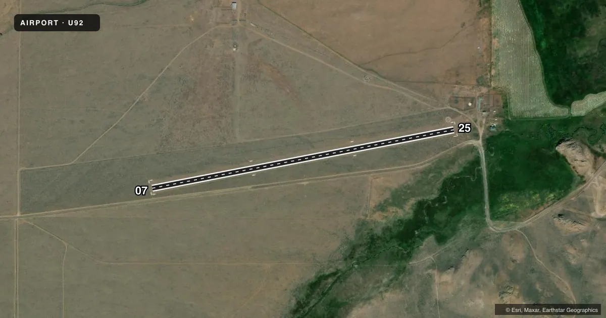
Airport sketch
Runways drawn to scale from FAA survey coordinates, rendered over satellite imagery. Not for navigation.
Approaches & charts
Services on the field
Fuel grades, oxygen, maintenance, ramp storage and lighting — as declared to the FAA by the airport operator.
Fuel & services
- Fuel
- Not available
- Oxygen (bottled)
- Not available
- Oxygen (bulk)
- Not available
- Airframe repair
- Not available
- Power plant repair
- Not available
Ramp & ground
- Transient storage
- Tie-down
- Landing fee
- No fee published
- Customs
- Not available
- Wind indicator
- Yes
- Segmented circle
- Yes
Fuel & FBOs
Cheapest 100LL and Jet A on the field and nearby. Always confirm with the FBO before taxi.
Airport notes
Surface conditions, obstructions, local procedures, lighting outages and other notes published with each FAA cycle.
General notes
- NO WINTER MAINT.
- RECOMMEND LNDG RWY 07; TKOF RWY 25 WHEN WIND CONDITIONS ALLOW.
- ARPT LCTD IN MOUNTAIN VALLEY SURROUNDED BY HIGH TERRAIN.
- FARM MACHINERY & TRUCKS FREQUENTLY PARKED ON THE APCH TO RY 25.
- +5 FT SAGEBRUSH ADJACENT TO BOTH RY EDGES AND RY 07 THLD.
- RY 07 +5 FT BRUSH 0 FT ON CNTRLN; +4 FT FENCE 0 FT 115 FT R.
- RWY 25 +30 FT PLINE 350 FT ON CTRLN; +4 FT FENCE 100 FT ON CTRLN; +15 FT ROAD 200 FT ON CTRLN; 450 FT MTN 4000 FT 200 FT L.
- FOR CD CTC SALT LAKE ARTCC AT 801-320-2568.
Approach & departure obstructions
- 07RWY 07/25 EDGES & THR MKD WITH W ROCK BDRY MKRS.
Other notes
- ESTABD PRIOR TO 1959.
- 1 SET TIEDOWNS
VFR map & nearby airports
VFR sectional. Tap any ICAO chip to open that airport.
Key facts · U92
Answer card- ICAO
- U92
- Name
- ANTELOPE VALLEY
- Location
- MOORE, IDAHO
- Elevation
- 6,193 ft MSL
- Traffic pattern altitude
- 7,193 ft MSL (1,000 AGL)
- Control tower
- Non-towered (use CTAF)
- Total runways
- 1
- Longest runway
- 07/25 · 3,450 ft
- Published ILS approaches
- 0
- Published frequencies
- 1
- Magnetic variation
- 16°
- Current flight rules
- VFR
- Current wind
- 310° at 11 kt
- Favored runway now
- RWY 25
Antelope Valley Airport (U92) sits near Moore, Idaho. The field elevation is 6,193 ft MSL. It has one runway. Runway 07/25 is 3,450 ft of turf, so performance planning matters here. There is no control tower. CTAF is 122.9. No ILS approaches are published.
The pattern altitude is not published. Use 7,193 ft MSL as the standard 1,000 ft AGL pattern reference for light piston operations unless the current FAA Chart Supplement says otherwise. This is a mountain valley airport surrounded by high terrain. Density altitude can be a real factor at this elevation. Plan for longer takeoff rolls and reduced climb. The published remarks also call out obstructions. Runway 25 has a power line, a fence, a road and mountain terrain off the departure end area. Runway 07 has brush on the centerline plus a fence off to the right. Farm machinery and trucks are often parked on the approach to runway 25. When wind allows, the published recommendation is to land 07 and depart 25. There is no winter maintenance. One set of tiedowns is available. No on-field FBOs are listed, so verify services with the airport operator or the field on CTAF before you go.