METAR & TAF U46
U46 does not publish a METAR.
Showing the nearest reporting station: KPIH (POCATELLO RGNL) · 37.3 NM away. Conditions at U46 may differ.
METAR · KPIH
Observed 13:53Z
KPIH 271353Z 22005KT 3SM HZ CLR 23/03 A3007 RMK AO2 SLP117 T02280033
- Wind
- 220° @ 5 kt
- Visibility
- 3 SM
- Temp / Dew
- 23°C / 3°C
- Altimeter
- 30.07 inHg
- Clouds
- CLR
- Density alt
- 7,065 ft
- Ceiling
- Unlimited
- Rules
- MVFR
Airport info & contacts
Manager on record, flight service, ARTCC, attendance schedule and pattern altitude — published by the FAA and refreshed every 28 days.
Location
- From city
- 10 NM W
- VFR sectional
- SALT LAKE CITY
- ARTCC
- ZLC · SALT LAKE CITY
- NOTAM facility
- BOI (NOTAM-D)
Airport manager
- Name
- IDAHO DIV OF AERONAUTICS
- Phone
- 208-334-8775
- Address
- P O BOX 7129, BOISE ID 83707-1129
Flight service · Hours
- FSS BOI
- BOISE1-800-WX-BRIEF
- Attendance
- Unattended
Frequencies
Tap any row to copy the frequency to your clipboard.
Runways & pattern
Full pagePattern entry · RWY 19
LEFT TRAFFICRunway end performance
| End | TORA | TODA | ASDA | LDA | VGSI | Approach lights | Obstruction |
|---|---|---|---|---|---|---|---|
| 19 | — | — | — | — | — | — | 14', road, 0' from thr, 100' R of cntrln, slope 0 |
Declared distances in feet. TORA = takeoff run available, TODA = takeoff distance, ASDA = accelerate-stop, LDA = landing distance.
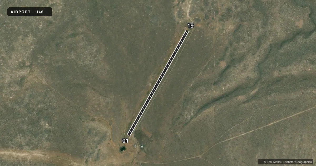
Airport sketch
Runways drawn to scale from FAA survey coordinates, rendered over satellite imagery. Not for navigation.
Approaches & charts
Services on the field
Fuel grades, oxygen, maintenance, ramp storage and lighting — as declared to the FAA by the airport operator.
Fuel & services
- Fuel
- Not available
- Oxygen (bottled)
- Not available
- Oxygen (bulk)
- Not available
- Airframe repair
- Not available
- Power plant repair
- Not available
Ramp & ground
- Transient storage
- Tie-down
- Landing fee
- No fee published
- Customs
- Not available
- Wind indicator
- Yes
- Segmented circle
- Yes
Fuel & FBOs
Cheapest 100LL and Jet A on the field and nearby. Always confirm with the FBO before taxi.
Airport notes
Surface conditions, obstructions, local procedures, lighting outages and other notes published with each FAA cycle.
General notes
- NO WINTER MAINTENANCE.
- LIVESTOCK ON & INVOF ARPT.
- RWY 01/19 SFC COND POOR DUE TO LIVESTOCK DMG, GND VEHICLES, RODENTS, & VEGETATION.
- RY 01/19 +1.5 FT BERM & -1 FT DITCH ADJACENT TO ENTIRE PERIMETER OF RY.
- FOR CD CTC SALT LAKE ARTCC AT 801-320-2568.
- APRT LCTD IN DESOLATE AREA - NO SVCS AVBL.
Approach & departure obstructions
- 0101/19 EDGES & THLDS MKD WITH WHITE ROCK BOUNDARY MKRS (BMS).
- 1914 FT RD 150 FT ON EXTDD CNTRLN.
Other notes
- EXISTED PRIOR TO 15 MAY 1959.
VFR map & nearby airports
VFR sectional. Tap any ICAO chip to open that airport.
Key facts · U46
Answer card- ICAO
- U46
- Name
- BIG SOUTHERN BUTTE
- Location
- ATOMIC CITY, IDAHO
- Elevation
- 5,073 ft MSL
- Traffic pattern altitude
- 6,073 ft MSL (1,000 AGL)
- Control tower
- Non-towered (use CTAF)
- Total runways
- 1
- Longest runway
- 01/19 · 2,600 ft
- Published ILS approaches
- 0
- Published frequencies
- 1
- Magnetic variation
- 16°
- Current flight rules
- MVFR
- Current wind
- 220° at 5 kt
- Favored runway now
- RWY 19
Big Southern Butte (U46) sits near Atomic City, Idaho. Field elevation is 5,073 ft MSL. The airport has one runway. Runway 01/19 is 2,600 ft long and dirt. The field is not towered. CTAF is 122.9. No ILS approaches are published.
Pattern altitude is not published. Use the standard 1,000 ft AGL pattern for light piston operations unless the current Chart Supplement says otherwise. The runway is marked with white rock boundary markers at the edges and thresholds. Published remarks also note poor runway surface condition from livestock damage, ground vehicles, rodents and vegetation. Livestock are on and near the airport. There is a 1.5 ft berm and a 1 ft ditch along the runway perimeter. A 14 ft road sits 150 ft on the extended centerline of runway 19.
No on-field FBOs are listed. The airport has no services available. No winter maintenance is provided. For clearance delivery, contact Salt Lake ARTCC at 801-320-2568. This is a high-elevation, remote strip with no tower and no published ILS. Plan conservatively for performance, surface condition and daylight operations if you are unfamiliar with the field.