METAR & TAF U87
U87 does not publish a METAR.
Showing the nearest reporting station: KSUN (FRIEDMAN MEML) · 32.8 NM away. Conditions at U87 may differ.
METAR · KSUN
Observed 12:50Z
KSUN 271250Z AUTO 32008KT 10SM OVC043 15/02 A3016 RMK AO2
- Wind
- 320° @ 8 kt
- Visibility
- 10 SM
- Temp / Dew
- 15°C / 2°C
- Altimeter
- 30.16 inHg
- Clouds
- OVC
- Density alt
- 8,638 ft
- Ceiling
- 4,300 ft AGL
- Rules
- VFR
Airport info & contacts
Manager on record, flight service, ARTCC, attendance schedule and pattern altitude — published by the FAA and refreshed every 28 days.
Location
- From city
- 0 NM E
- VFR sectional
- SALT LAKE CITY
- ARTCC
- ZLC · SALT LAKE CITY
- NOTAM facility
- BOI (NOTAM-D)
Airport manager
- Name
- IDAHO DIV OF AERONAUTICS
- Phone
- 208-334-8775
- Address
- P O BOX 7129, BOISE ID 83707-1129
Flight service · Hours
- FSS BOI
- BOISE1-800-WX-BRIEF
- Attendance
- Unattended
Frequencies
Tap any row to copy the frequency to your clipboard.
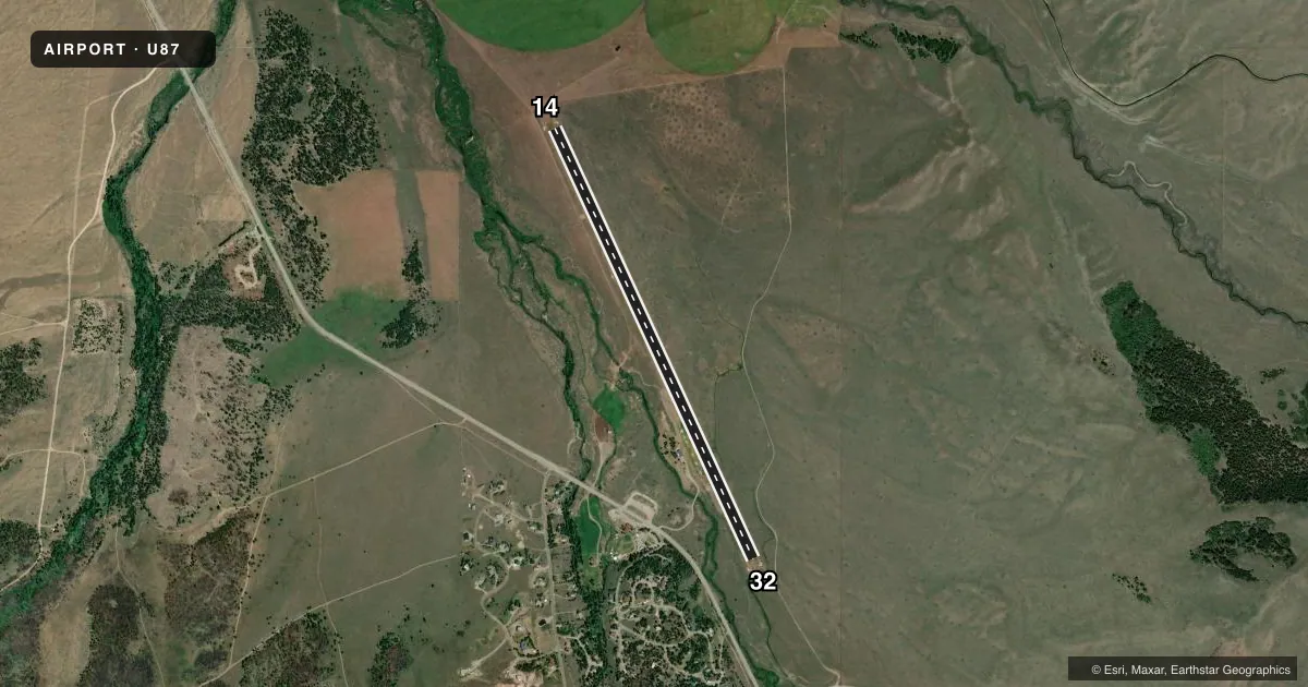
Runways & pattern
Full pagePattern entry · RWY 32
LEFT TRAFFICRunway end performance
| End | TORA | TODA | ASDA | LDA | VGSI | Approach lights | Obstruction |
|---|---|---|---|---|---|---|---|
| 14 | — | — | — | — | — | — | 4', fence, 0' from thr, 100' R of cntrln, slope 0 |
| 32 | — | — | — | — | — | — | 5', fence, 0' from thr, 100' R of cntrln, slope 0 |
Declared distances in feet. TORA = takeoff run available, TODA = takeoff distance, ASDA = accelerate-stop, LDA = landing distance.
Airport sketch
Runways drawn to scale from FAA survey coordinates, rendered over satellite imagery. Not for navigation.
Approaches & charts
Services on the field
Fuel grades, oxygen, maintenance, ramp storage and lighting — as declared to the FAA by the airport operator.
Fuel & services
- Fuel
- Not available
- Oxygen (bottled)
- Not available
- Oxygen (bulk)
- Not available
- Airframe repair
- Not available
- Power plant repair
- Not available
Ramp & ground
- Transient storage
- Tie-down
- Landing fee
- No fee published
- Customs
- Not available
- Wind indicator
- Yes
- Segmented circle
- Yes
Fuel & FBOs
Cheapest 100LL and Jet A on the field and nearby. Always confirm with the FBO before taxi.
Airport notes
Surface conditions, obstructions, local procedures, lighting outages and other notes published with each FAA cycle.
General notes
- NO WINTER MAINTENANCE.
- RECOMMEND LNDG RY 14 TKOF RY 32 WHEN WIND CONDITIONS ALLOW.
- BE ALERT FOR SPRINKLERS/STAND PIPES ON EDGE OF RY.
- ARPT LCTD IN VALLEY SURROUNDED BY HIGH MOUNTAINOUS TERRAIN.
- EXTREMELY HIGH DENSITY ALTITUDE CONDITIONS EXIST DURING SUMMER MONTHS.
- FOR CD CTC SALT LAKE ARTCC AT 801-320-2568.
Approach & departure obstructions
- 1414/32 EDGES & THRS MKD WITH WHITE ROCK BOUNDARY MKRS.
- 144 FT FENCE 200 FT ON CNTRLN, +3 FT BERM & CREEK 60 FT ON CNTRLN.
- 32RWY 32 5 FT FENCE 200 FT ON CNTRLN, +2 FT BERM 60 FT ON CNTRLN, 15FT BRUSH 75 FT 100 FT L, +2 FT SPRINKLER VALVE 50 FT 35 FT L.
Other notes
- PRIVATE LAND LEASED TO THE IDAHO DIVISION OF AERONAUTICS.
VFR map & nearby airports
VFR sectional. Tap any ICAO chip to open that airport.
Key facts · U87
Answer card- ICAO
- U87
- Name
- SMILEY CREEK
- Location
- SMILEY CREEK, IDAHO
- Elevation
- 7,206 ft MSL
- Traffic pattern altitude
- 8,206 ft MSL (1,000 AGL)
- Control tower
- Non-towered (use CTAF)
- Total runways
- 1
- Longest runway
- 14/32 · 4,900 ft
- Published ILS approaches
- 0
- Published frequencies
- 1
- Magnetic variation
- 17°
- Current flight rules
- VFR
- Current wind
- 320° at 8 kt
- Favored runway now
- RWY 32
Smiley Creek Airport is in Smiley Creek, Idaho. The field elevation is 7,206 ft MSL. It has one runway. Runway 14/32 is 4,900 ft long and turf. There is no control tower. CTAF is 122.9. No ILS approaches are published.
The traffic pattern altitude is not published. Use the standard 1,000 ft AGL for light piston traffic unless the current FAA Chart Supplement says otherwise. The airport sits in a valley surrounded by high mountainous terrain. That matters here. Summer density altitude can be extreme. Performance planning should be conservative. No winter maintenance is provided.
Published remarks also call out obstructions near both runway ends. Runway 32 has a fence, berm, brush and a sprinkler valve near the centerline. Runway 14 has a fence, berm and a creek near the centerline. White rock boundary markers mark the runway edges and thresholds. The remarks recommend landing runway 14 and taking off runway 32 when wind allows. There are no on-field FBOs listed. Check with the airport operator or the FBO directly by phone if you need current fuel or services before arrival. For clearance delivery, contact Salt Lake ARTCC at 801-320-2568.