METAR & TAF 0U1
0U1 does not publish a METAR.
Showing the nearest reporting station: KLLJ (CHALLIS) · 52.3 NM away. Conditions at 0U1 may differ.
METAR · KLLJ
Observed 13:55Z
KLLJ 241355Z AUTO 13003KT 10SM CLR 16/02 A3014 RMK AO2 SLP138 T01610017
- Wind
- 130° @ 3 kt
- Visibility
- 10 SM
- Temp / Dew
- 16°C / 2°C
- Altimeter
- 30.14 inHg
- Clouds
- CLR
- Density alt
- 5,838 ft
- Ceiling
- Unlimited
- Rules
- VFR
Airport info & contacts
Manager on record, flight service, ARTCC, attendance schedule and pattern altitude — published by the FAA and refreshed every 28 days.
Location
- From city
- 13 NM NE
- VFR sectional
- SALT LAKE CITY
- ARTCC
- ZLC · SALT LAKE CITY
- NOTAM facility
- BOI (NOTAM-D)
Airport manager
- Name
- IDAHO ITD/DIV OF AERONAUTICS
- Phone
- 208-334-8775
- Address
- P O BOX 7129, BOISE ID 83707-1129
Flight service · Hours
- FSS BOI
- BOISE1-800-WX-BRIEF
- Attendance
- Unattended
Frequencies
Tap any row to copy the frequency to your clipboard.
Runways & pattern
Full pagePattern entry · RWY 02
LEFT TRAFFICRunway end performance
| End | TORA | TODA | ASDA | LDA | VGSI | Approach lights | Obstruction |
|---|---|---|---|---|---|---|---|
| 02 | — | — | — | — | — | — | 18', tree, 15' from thr, 90' R of cntrln, slope 0 |
| 20 | — | — | — | — | — | — | 85', trees, 70' from thr, 0' R of cntrln, slope 0 |
Declared distances in feet. TORA = takeoff run available, TODA = takeoff distance, ASDA = accelerate-stop, LDA = landing distance.
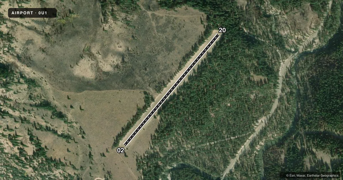
Airport sketch
Runways drawn to scale from FAA survey coordinates, rendered over satellite imagery. Not for navigation.
Approaches & charts
Services on the field
Fuel grades, oxygen, maintenance, ramp storage and lighting — as declared to the FAA by the airport operator.
Fuel & services
- Fuel
- Not available
- Oxygen (bottled)
- Not available
- Oxygen (bulk)
- Not available
- Airframe repair
- Not available
- Power plant repair
- Not available
Ramp & ground
- Transient storage
- Tie-down
- Landing fee
- No fee published
- Wind indicator
- Yes
- Segmented circle
- Yes
Fuel & FBOs
Cheapest 100LL and Jet A on the field and nearby. Always confirm with the FBO before taxi.
Airport notes
Surface conditions, obstructions, local procedures, lighting outages and other notes published with each FAA cycle.
General notes
- NO WINTER MAINTENANCE.
- RECOMMEND LND RY 02; TKOF RY 20 WHEN WIND CONDITIONS ALLOW.
- NO LINE OF SIGHT BETWEEN RY ENDS.
- NO TELEPHONE AVBL AT ARPT.
- FOR CD CTC SALT LAKE ARTCC AT 801-320-2568.
Approach & departure obstructions
- 0202/20 EDGES AND THRS MARKED WITH WHITE ROCKS.
- 02SLP 0:1 WITH DOWN SLPG TRRN AND SOME SCATTERED TREES 12-15 FT TALL.
- 20APCH BLOCKED BY TRRN W/80 FT+ TALL TREES & BRUSH.
Other notes
- ESTABD PRIOR TO 12/31/58.
- ONLY HALF OF A SEGMENTED CRC.
VFR map & nearby airports
VFR sectional. Tap any ICAO chip to open that airport.
Key facts · 0U1
Answer card- ICAO
- 0U1
- Name
- WARM SPRINGS CREEK
- Location
- LOWMAN, IDAHO
- Elevation
- 4,831 ft MSL
- Traffic pattern altitude
- 5,831 ft MSL (1,000 AGL)
- Control tower
- Non-towered (use CTAF)
- Total runways
- 1
- Longest runway
- 02/20 · 2,850 ft
- Published ILS approaches
- 0
- Published frequencies
- 1
- Magnetic variation
- 17°
- Current flight rules
- VFR
- Current wind
- 130° at 3 kt
- Favored runway now
- RWY 02
Warm Springs Creek Airport sits near Lowman, Idaho. Field elevation is 4,831 ft MSL. It has one runway. Runway 02/20 is 2,850 ft of turf, so this is a short backcountry-style field with mountain flying considerations. There is no control tower. CTAF is 122.9. No ILS approaches are published.
Pattern altitude is not published. Use the standard 1,000 ft AGL for light piston operations unless the current Chart Supplement or local guidance says otherwise. The published remarks matter here. Runway 02 is the preferred landing runway. Takeoff on runway 20 is recommended when wind allows. Runway 20 has terrain and tall trees on the approach side. Runway 02 has downsloping terrain with scattered trees near the runway. The runway edges and thresholds are marked with white rocks. There is no line of sight between runway ends. Only half of a segmented circle is present.
No on-field FBOs are listed. No telephone is available at the airport. Winter maintenance is not provided. For clearance delivery, contact Salt Lake ARTCC at 801-320-2568. A first-time pilot should plan for the elevation. Plan for the turf surface too. The terrain on both ends deserves attention. Verify current conditions before you go.