METAR & TAF U70
U70 does not publish a METAR.
Showing the nearest reporting station: KMYL (MC CALL MUNI) · 24.1 NM away. Conditions at U70 may differ.
METAR · KMYL
Observed 12:51Z
KMYL 271251Z AUTO 23003KT OVC048 09/06 A3015 RMK AO2 SLP168 T00890061 $
- Wind
- 230° @ 3 kt
- Visibility
- —
- Temp / Dew
- 9°C / 6°C
- Altimeter
- 30.15 inHg
- Clouds
- OVC
- Density alt
- 4,882 ft
- Ceiling
- 4,800 ft AGL
- Rules
- VFR
Airport info & contacts
Manager on record, flight service, ARTCC, attendance schedule and pattern altitude — published by the FAA and refreshed every 28 days.
Location
- From city
- 2 NM SE
- VFR sectional
- SALT LAKE CITY
- ARTCC
- ZLC · SALT LAKE CITY
- NOTAM facility
- BOI (NOTAM-D)
Airport manager
- Name
- MIKE ARNOLD
- Phone
- 208-382-4844
- Address
- BOX 1094, CASCADE ID 83611
Flight service · Hours
- FSS BOI
- BOISE1-800-WX-BRIEF
- Attendance
- DEC-APR · 0900-1700
- MAY-NOV · 0800-1800
Frequencies
Tap any row to copy the frequency to your clipboard.
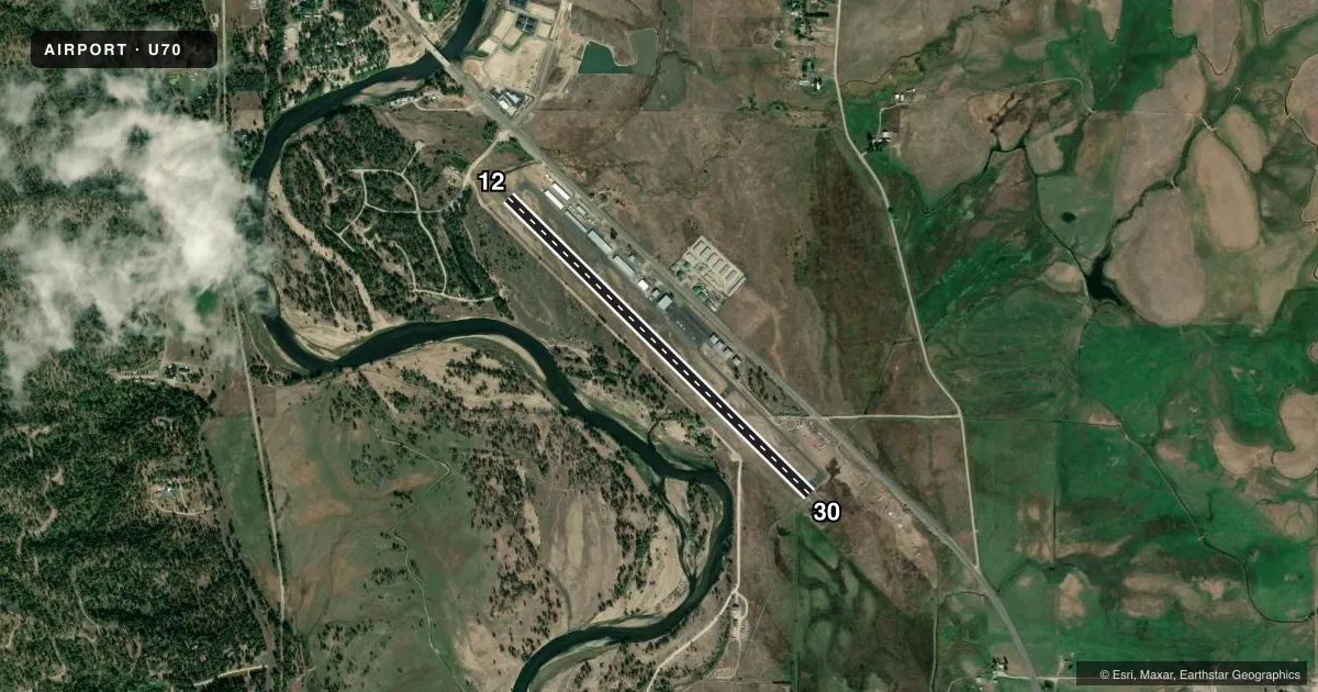
Runways & pattern
Full pagePattern entry · RWY 30
RIGHT TRAFFICRunway end performance
| End | TORA | TODA | ASDA | LDA | VGSI | Approach lights | Obstruction |
|---|---|---|---|---|---|---|---|
| 12 | — | — | — | — | — | — | 40', trees, 550' from thr, 75' R of cntrln, slope 8 |
Declared distances in feet. TORA = takeoff run available, TODA = takeoff distance, ASDA = accelerate-stop, LDA = landing distance.
Airport sketch
Runways drawn to scale from FAA survey coordinates, rendered over satellite imagery. Not for navigation.
Approaches & charts
Services on the field
Fuel grades, oxygen, maintenance, ramp storage and lighting — as declared to the FAA by the airport operator.
Fuel & services
- Fuel
- 100LLA
- Oxygen (bottled)
- Low pressure
- Oxygen (bulk)
- Not available
- Airframe repair
- Major
- Power plant repair
- Major
- Other services
- CHTR,INSTR
Ramp & ground
- Transient storage
- Tie-down
- Landing fee
- No fee published
- Customs
- Not available
- Lighting schedule
- SEE RMK
- Beacon schedule
- SS-SR
- Beacon
- White / Green (civil land)(WG)
- Wind indicator
- Lighted
- Segmented circle
- Yes
Fuel & FBOs
Cheapest 100LL and Jet A on the field and nearby. Always confirm with the FBO before taxi.
Airport notes
Surface conditions, obstructions, local procedures, lighting outages and other notes published with each FAA cycle.
General notes
- RETROREFLECTIVE REFLECTORS ON TWYS & RAMP EDGES.
- RWY 12 +300 FT TIMBERED RDG AT 1.25 MIS ON CNTRLN.
Lighting notes
- ACTVT MIRL RWY 12/30 AND WINDSOCK LIGHTS - CTAF.
Runway surface & condition
- 12/30TO AVOID APCH/DEP OVR TOWN; LND RY 30 & DEP RY 12 WHEN WND CONDS PMT.
Other notes
- ESTABD PRIOR TO 15 MAY 1959.
VFR map & nearby airports
VFR sectional. Tap any ICAO chip to open that airport.
Key facts · U70
Answer card- ICAO
- U70
- Name
- CASCADE
- Location
- CASCADE, IDAHO
- Elevation
- 4,748 ft MSL
- Traffic pattern altitude
- 5,748 ft MSL (1,000 AGL)
- Control tower
- Non-towered (use CTAF)
- Total runways
- 1
- Longest runway
- 12/30 · 4,300 ft
- Published ILS approaches
- 0
- Published frequencies
- 1
- Magnetic variation
- 17°
- Current flight rules
- VFR
- Current wind
- 230° at 3 kt
- Favored runway now
- RWY 30
Cascade Airport sits in Cascade, Idaho at 4,748 ft MSL. It has one runway, 12/30, which is 4,300 ft of asphalt. There is no control tower. CTAF is 122.9. No ILS approaches are published here.
For pattern work, the published pattern altitude is not listed. Use the standard 1,000 ft AGL for light piston operations unless the current Chart Supplement says otherwise. That puts you at about 5,748 ft MSL based on the field elevation, but verify the current published traffic pattern before you fly. Arnold Aviation is on the field. It carries 100LL and Jet A. Call (208) 382-4844 for current service details.
The published remarks matter here. To keep traffic away from town when wind allows, land runway 30 and depart runway 12. Runway 12 also has a timbered ridge about 1.25 miles out on the centerline. The airport uses medium intensity runway lights and windsock lights, both activated on CTAF. Retroreflective markers are installed on the taxiways and ramp edges. At this elevation, performance planning matters. Expect higher density altitude effects, especially on warm days. Check the current Chart Supplement and the airport operator for any updates before you go.