METAR & TAF KMYL
Current METAR
Observed 05:51Z
KMYL 270551Z AUTO 00000KT OVC050 16/06 A3011 RMK AO2 SLP149 T01610061 10289 20156 50009 $
- Wind
- 000° @ 0 kt
- Visibility
- —
- Temp / Dew
- 16°C / 6°C
- Altimeter
- 30.11 inHg
- Clouds
- OVC
- Density alt
- 6,114 ft
- Ceiling
- 5,000 ft AGL
- Rules
- VFR
Airport info & contacts
Manager on record, flight service, ARTCC, attendance schedule and pattern altitude — published by the FAA and refreshed every 28 days.
Location
- From city
- 0 NM S
- VFR sectional
- GREAT FALLS
- ARTCC
- ZLC · SALT LAKE CITY
- NOTAM facility
- MYL (NOTAM-D)
Airport manager
- Name
- EMILY HART
- Phone
- 208-634-1488
- Address
- 216 E PARK, MC CALL ID 83638
Flight service · Hours
- FSS BOI
- BOISE1-800-WX-BRIEF
- Attendance
- MAY-SEP · 0800L-1800L
- OCT-APR · 0900L-1600L
Frequencies
Tap any row to copy the frequency to your clipboard.
Runways & pattern
Full pagePattern entry · RWY 16
LEFT TRAFFICRunway end performance
| End | TORA | TODA | ASDA | LDA | VGSI | Approach lights | Obstruction |
|---|---|---|---|---|---|---|---|
| 16 | — | — | — | — | — | — | 16', road, 650' from thr, 0' R of cntrln, slope 28 |
| 34 | — | — | — | — | VASI 2-box left(3.5°) | — | 80', gnd, 1500' from thr, 0' R of cntrln, slope 16 |
Declared distances in feet. TORA = takeoff run available, TODA = takeoff distance, ASDA = accelerate-stop, LDA = landing distance.
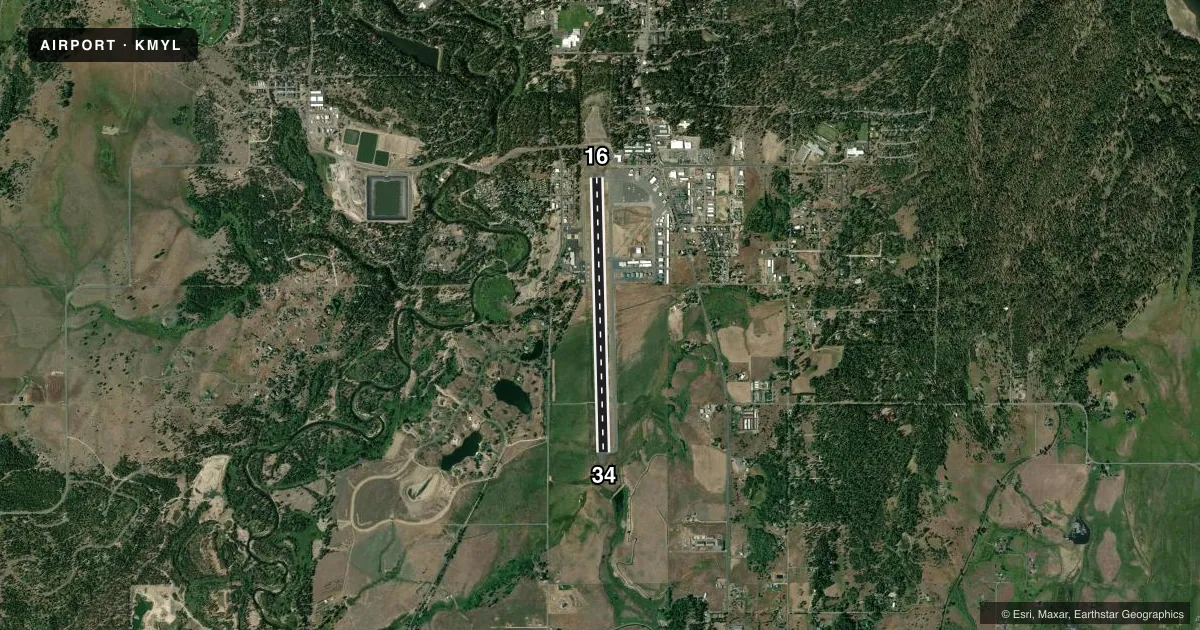
Airport sketch
Runways drawn to scale from FAA survey coordinates, rendered over satellite imagery. Not for navigation.
Approaches & charts
Services on the field
Fuel grades, oxygen, maintenance, ramp storage and lighting — as declared to the FAA by the airport operator.
Fuel & services
- Fuel
- 100LLAA1+
- Oxygen (bottled)
- Not available
- Oxygen (bulk)
- Not available
- Airframe repair
- Major
- Power plant repair
- Major
- Other services
- AMB,CHTR,INSTR,RNTL,SALES
Ramp & ground
- Transient storage
- Tie-down
- Hangar
- Landing fee
- No fee published
- Customs
- Not available
- Lighting schedule
- SEE RMK
- Beacon schedule
- SS-SR
- Beacon
- White / Green (civil land)(WG)
- Wind indicator
- Lighted
- Segmented circle
- Yes
Fuel & FBOs
Cheapest 100LL and Jet A on the field and nearby. Always confirm with the FBO before taxi.
Airport notes
Surface conditions, obstructions, local procedures, lighting outages and other notes published with each FAA cycle.
General notes
- USFS PRACTICES PARACHUTE JUMPS INVOF ARPT.
- BIG GAME ANIMALS MAY BE ON OR IN VICINITY OF RY.
- NO HELICOPTER PARKING IN FIXED WING TIE-DOWN AREAS.
- RY 16 HAS A MARKED 50 FT BLAST PAD.
- INCREASED FOREST SERVICE FLIGHT OPNS DURG SUMMER MONTHS.
- PARALLEL TWY CLSD DEC 1-APR 30.
- AUX PWR UNITS MAY NOT BE STARTED UNTIL 30 MINS PRIOR TO ENGINE START. FEES WILL BE CHRGD FOR APU USAGE OVER 30 MIN.
- COLD TEMPERATURE AIRPORT. ALTITUDE CORRECTION REQUIRED AT OR BELOW -19C.
- AIRPORT SURFACE CONDITIONS REPORTED M-F 0800-1700 LCL
- 2 HR PRIOR NOTICE REQUIRED FOR SNOW REMOVAL AT NIGHT CALL 208-634-1488/630-3441
- FOR CD CTC SALT LAKE ARTCC AT 801-320-2568.
- LNDG AND PRKG FEES COLLD BY THIRD PARTY PROVIDER. SEE MCCALLAIRPORT.COM FOR ADNL DTLS.
- SELF-SERVE 100LL ONLY.
Lighting notes
- ACTIVATE REIL RWY 16 & 34; MIRL RWY 16/34 - CTAF.
Runway surface & condition
- 16/34RECOMMEND LNDG RWY 34 AND TKOF RWY 16 WHEN WIND CONDS PERMIT.
Other notes
- ESTABD PRIOR TO 15 MAY 1959.
VFR map & nearby airports
VFR sectional. Tap any ICAO chip to open that airport.
Key facts · KMYL
Answer card- ICAO
- KMYL
- Name
- MC CALL MUNI
- Location
- MC CALL, IDAHO
- Elevation
- 5,024.1 ft MSL
- Traffic pattern altitude
- 6,024.1 ft MSL (1,000 AGL)
- Control tower
- Non-towered (use CTAF)
- Total runways
- 1
- Longest runway
- 16/34 · 6,101 ft
- Published ILS approaches
- 0
- Published frequencies
- 2
- Magnetic variation
- 13°
- Current flight rules
- VFR
- Current wind
- 000° at 0 kt
- Favored runway now
- –
McCall Muni is in McCall, Idaho. The field elevation is 5,024.1 ft MSL. It has one runway, 16/34, which is 6,101 ft long with an asphalt surface. There is no control tower. CTAF and UNICOM are both 122.8. No ILS approaches are published, so plan with the current chart and weather in mind.
The published pattern altitude is not given. For light piston aircraft, use the standard 1,000 ft AGL unless the current Chart Supplement or local procedures say otherwise. McCall Aviation is on the field. It carries 100LL, Jet A and Jet A Prist. Self-serve 100LL is available. The airport remarks also note runway edge and identifier lights are activated on CTAF. The parallel taxiway is closed from December 1 to April 30. That matters here because winter operations can be a factor at this elevation.
This is a cold temperature airport. Altitude correction is required at or below minus 19 degrees Celsius. Two hours prior notice is required for night snow removal. The remarks also say parachute jumps occur in the vicinity of the airport. For runway use, the published note recommends landing runway 34 and taking off runway 16 when wind conditions permit. Check the current Chart Supplement and coordinate with the airport or FBO before arrival if you need current surface conditions or winter support.