METAR & TAF U82
U82 does not publish a METAR.
Showing the nearest reporting station: KMYL (MC CALL MUNI) · 16.8 NM away. Conditions at U82 may differ.
METAR · KMYL
Observed 12:51Z
KMYL 271251Z AUTO 23003KT OVC048 09/06 A3015 RMK AO2 SLP168 T00890061 $
- Wind
- 230° @ 3 kt
- Visibility
- —
- Temp / Dew
- 9°C / 6°C
- Altimeter
- 30.15 inHg
- Clouds
- OVC
- Density alt
- 2,673 ft
- Ceiling
- 4,800 ft AGL
- Rules
- VFR
Airport info & contacts
Manager on record, flight service, ARTCC, attendance schedule and pattern altitude — published by the FAA and refreshed every 28 days.
Location
- From city
- 1 NM NW
- VFR sectional
- GREAT FALLS
- ARTCC
- ZLC · SALT LAKE CITY
- NOTAM facility
- BOI (NOTAM-D)
Airport manager
- Name
- KATHRYN HUGHES
- Phone
- 810-516-4028
- Address
- P O BOX 606, COUNCIL ID 83612
Flight service · Hours
- FSS BOI
- BOISE1-800-WX-BRIEF
- Attendance
- Unattended
Frequencies
Tap any row to copy the frequency to your clipboard.
Runways & pattern
Full pagePattern entry · RWY 18
LEFT TRAFFICRunway end performance
| End | TORA | TODA | ASDA | LDA | VGSI | Approach lights | Obstruction |
|---|---|---|---|---|---|---|---|
| 18 | — | — | — | — | — | — | 15', brush, 250' from thr, 125' R of cntrln, slope 3 |
Declared distances in feet. TORA = takeoff run available, TODA = takeoff distance, ASDA = accelerate-stop, LDA = landing distance.
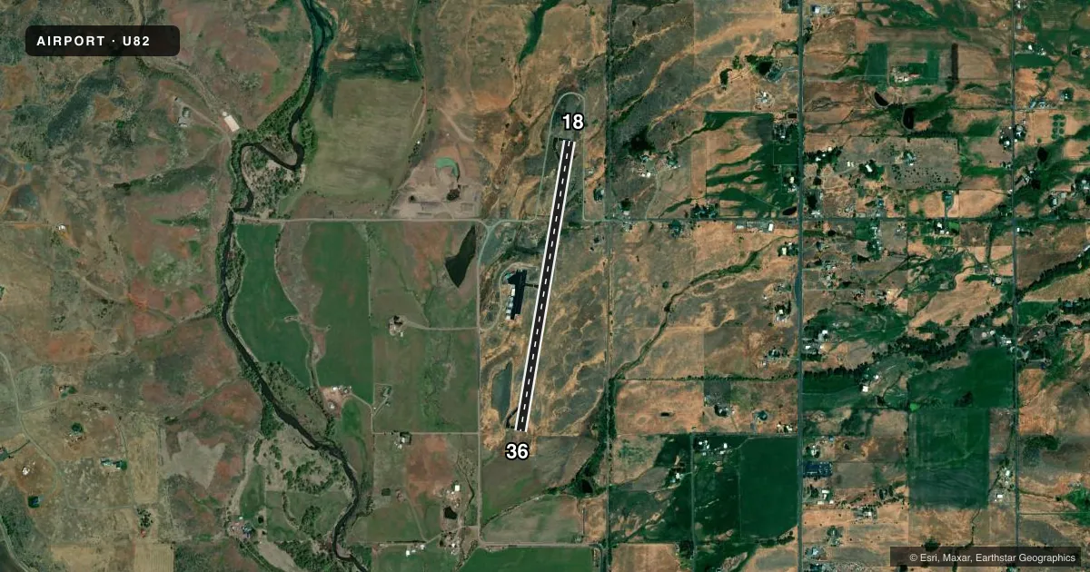
Airport sketch
Runways drawn to scale from FAA survey coordinates, rendered over satellite imagery. Not for navigation.
Approaches & charts
Services on the field
Fuel grades, oxygen, maintenance, ramp storage and lighting — as declared to the FAA by the airport operator.
Fuel & services
- Fuel
- 100LL
- Oxygen (bottled)
- Not available
- Oxygen (bulk)
- Not available
- Airframe repair
- Not available
- Power plant repair
- Not available
Ramp & ground
- Transient storage
- Tie-down
- Landing fee
- No fee published
- Customs
- Not available
- Lighting schedule
- SEE RMK
- Beacon schedule
- SS-SR
- Beacon
- White / Green (civil land)(WG)
- Wind indicator
- Lighted
- Segmented circle
- Yes
Fuel & FBOs
Cheapest 100LL and Jet A on the field and nearby. Always confirm with the FBO before taxi.
Airport notes
Surface conditions, obstructions, local procedures, lighting outages and other notes published with each FAA cycle.
General notes
- ARPT SURROUNDED BY MTNS ALL QUADRANTS.
- FOR CD CTC SALT LAKE ARTCC AT 801-320-2568.
Lighting notes
- ACTVT MIRL RWY 18/36 - CTAF.
Other notes
- ESTABD PRIOR TO 15 MAY 1959.
VFR map & nearby airports
VFR sectional. Tap any ICAO chip to open that airport.
Key facts · U82
Answer card- ICAO
- U82
- Name
- COUNCIL MUNI
- Location
- COUNCIL, IDAHO
- Elevation
- 2,966 ft MSL
- Traffic pattern altitude
- 3,966 ft MSL (1,000 AGL)
- Control tower
- Non-towered (use CTAF)
- Total runways
- 1
- Longest runway
- 18/36 · 3,600 ft
- Published ILS approaches
- 0
- Published frequencies
- 2
- Magnetic variation
- 18°
- Current flight rules
- VFR
- Current wind
- 230° at 3 kt
- Favored runway now
- RWY 18
Council Muni Airport sits in Council, Idaho at 2,966 ft MSL. It has one runway. Runway 18/36 is 3,600 ft long with an asphalt surface. The airport is not towered. CTAF and UNICOM are both 122.8. No ILS approaches are published here.
The published pattern altitude is not listed. Use the standard 1,000 ft AGL unless the current Chart Supplement says otherwise. That puts the light aircraft pattern at about 3,966 ft MSL based on the field elevation. The airport is surrounded by mountains in all quadrants. That matters for climb performance, descent planning and wind shifts in the pattern.
Council Municipal Airport is the on-field FBO. It carries 100LL. Call (208) 253-4201 before arrival if you need current ramp or service details. Published remarks also note medium intensity runway lights on runway 17/35 that are controlled by CTAF. For clearance delivery, contact Salt Lake ARTCC at 801-320-2568. The field was established prior to 15 May 1959. For any current noise, lighting, or operating details not shown here, check the current Chart Supplement or call the airport operator directly.