METAR & TAF 0U0
0U0 does not publish a METAR.
Showing the nearest reporting station: KMYL (MC CALL MUNI) · 28.4 NM away. Conditions at 0U0 may differ.
METAR · KMYL
Observed 03:51Z
KMYL 270351Z AUTO 06003KT OVC046 19/04 A3009 RMK AO2 SLP145 T01940039 $
- Wind
- 060° @ 3 kt
- Visibility
- —
- Temp / Dew
- 19°C / 4°C
- Altimeter
- 30.09 inHg
- Clouds
- OVC
- Density alt
- 8,530 ft
- Ceiling
- 4,600 ft AGL
- Rules
- VFR
Airport info & contacts
Manager on record, flight service, ARTCC, attendance schedule and pattern altitude — published by the FAA and refreshed every 28 days.
Location
- From city
- 1 NM SE
- VFR sectional
- GREAT FALLS
- ARTCC
- ZLC · SALT LAKE CITY
- NOTAM facility
- BOI (NOTAM-D)
Airport manager
- Name
- CASCADE RANGER DISTRICT
- Phone
- (208) 382-7400
- Address
- 540 NORTH MAIN STREET, P.O. BOX 696, CASCADE ID 83611
Flight service · Hours
- FSS BOI
- BOISE1-800-WX-BRIEF
- Attendance
- Unattended
Frequencies
Tap any row to copy the frequency to your clipboard.
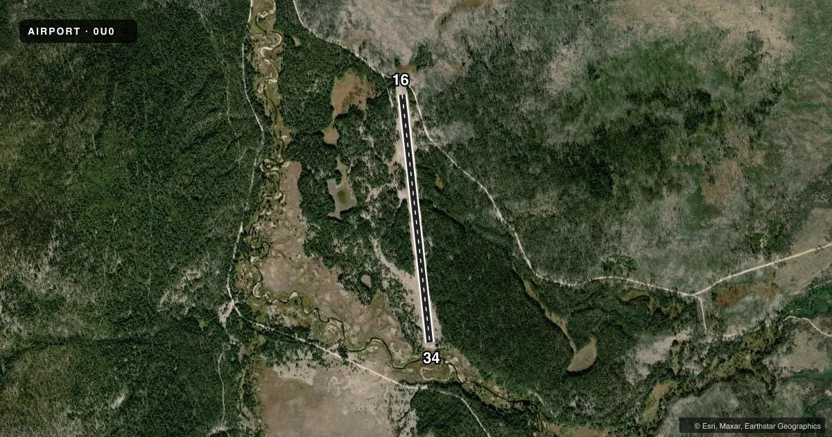
Runways & pattern
Full pagePattern entry · RWY 34
LEFT TRAFFICRunway end performance
| End | TORA | TODA | ASDA | LDA | VGSI | Approach lights | Obstruction |
|---|---|---|---|---|---|---|---|
| 16 | — | — | — | — | — | — | 65', trees, 0' from thr, 100' R of cntrln, slope 0 |
| 34 | — | — | — | — | — | — | 60', tree, 0' from thr, 105' R of cntrln, slope 0 |
Declared distances in feet. TORA = takeoff run available, TODA = takeoff distance, ASDA = accelerate-stop, LDA = landing distance.
Airport sketch
Runways drawn to scale from FAA survey coordinates, rendered over satellite imagery. Not for navigation.
Approaches & charts
Services on the field
Fuel grades, oxygen, maintenance, ramp storage and lighting — as declared to the FAA by the airport operator.
Fuel & services
- Fuel
- Not available
- Oxygen (bottled)
- Not available
- Oxygen (bulk)
- Not available
- Airframe repair
- Not available
- Power plant repair
- Not available
Ramp & ground
- Transient storage
- Tie-down
- Landing fee
- No fee published
- Wind indicator
- Yes
- Segmented circle
- Yes
Fuel & FBOs
Cheapest 100LL and Jet A on the field and nearby. Always confirm with the FBO before taxi.
Airport notes
Surface conditions, obstructions, local procedures, lighting outages and other notes published with each FAA cycle.
General notes
- NO TELEPHONE AVBL AT ARPT.
- NO WINTER MAINTENANCE.
- RY 16/34 NO LINE OF SIGHT BTN RY ENDS.
- ARPT LCTD IN HIGH MTN VALLEY SURROUNDED BY HIGH TERRAIN.
- VEHICLE TRAFFIC ON AND INVOF ARPT.
- FOR CD CTC SALT LAKE ARTCC AT 801-320-2568.
- RWY 16/34 - FIRST 800-1000 FT OF RWY 34 MAY BE SOFT AND SOGGY DUE TO LATE SNOW MELT TIL JUN OF EACH YEAR.
- WILDLIFE ON & INVOF ARPT.
Approach & departure obstructions
- 1616/34 EDGES MKD WITH WHITE ROCK MARKERS.
- 1665 FT + TREES PRESENT ON BOTH SIDES OF THE RWY EDGES.
- 16+13 FT RD AT 70 FT ON CNTRLN; +60 FT TREES 175 FT, 30 FT L; +125 FT TREES & RISING TRRN AT 350 FT ON CNTRLN.
- 34RY 34 +50 FT TREE 0 FT; 120 FT R; +150 FT TREES & TERRAIN 1200 FT ON CNTRLN.
Other notes
- EXISTED PRIOR TO 31 DEC 1958.
- NSTD SEGMENTED CIRCLE. 10 FT DIAMETER.
VFR map & nearby airports
VFR sectional. Tap any ICAO chip to open that airport.
Key facts · 0U0
Answer card- ICAO
- 0U0
- Name
- LANDMARK USFS
- Location
- LANDMARK, IDAHO
- Elevation
- 6,662 ft MSL
- Traffic pattern altitude
- 7,662 ft MSL (1,000 AGL)
- Control tower
- Non-towered (use CTAF)
- Total runways
- 1
- Longest runway
- 16/34 · 4,000 ft
- Published ILS approaches
- 0
- Published frequencies
- 1
- Magnetic variation
- 17°
- Current flight rules
- VFR
- Current wind
- 060° at 3 kt
- Favored runway now
- RWY 34
LANDMARK USFS (0U0) sits in Landmark, Idaho. The field elevation is 6,662 ft MSL. It has one runway, 16/34, which is 4,000 ft long and surfaced turf-dirt. There is no control tower. No ILS approaches are published. Pattern altitude is not published, so use the standard 1,000 ft AGL for light piston operations unless the current FAA Chart Supplement says otherwise.
This is a high mountain valley airport surrounded by high terrain. That matters here. The runway has no line of sight between the ends. Runway 16 has a 13 ft road on the centerline at 70 ft. Trees also sit close in. Expect 60 ft trees 175 ft left of centerline on the 16 end. Expect 125 ft trees plus rising terrain 350 ft on centerline. Sixty-five foot plus trees are present on both sides of the runway edges. Runway 34 can be soft and soggy in the first 800 to 1,000 ft until June because of late snow melt. No winter maintenance is provided.
CTAF is 122.9. For clearance delivery, contact Salt Lake ARTCC at 801-320-2568. Wildlife is on and near the airport. Vehicle traffic is also in the area. There is no telephone at the airport. There are no on-field FBOs listed, so verify services with the airport operator or call the field directly before you go.