METAR & TAF 3U2
3U2 does not publish a METAR.
Showing the nearest reporting station: KMYL (MC CALL MUNI) · 26.2 NM away. Conditions at 3U2 may differ.
METAR · KMYL
Observed 04:51Z
KMYL 270451Z AUTO 36004KT OVC048 18/07 A3011 RMK AO2 SLP152 T01780072 $
- Wind
- 360° @ 4 kt
- Visibility
- —
- Temp / Dew
- 18°C / 7°C
- Altimeter
- 30.11 inHg
- Clouds
- OVC
- Density alt
- 6,275 ft
- Ceiling
- 4,800 ft AGL
- Rules
- VFR
Airport info & contacts
Manager on record, flight service, ARTCC, attendance schedule and pattern altitude — published by the FAA and refreshed every 28 days.
Location
- From city
- 3 NM S
- VFR sectional
- GREAT FALLS
- ARTCC
- ZLC · SALT LAKE CITY
- NOTAM facility
- BOI (NOTAM-D)
Airport manager
- Name
- DIVISION ADMIN
- Phone
- 208-334-8775
- Address
- BOX 7129, BOISE ID 83707-1129
Flight service · Hours
- FSS BOI
- BOISE1-800-WX-BRIEF
- Attendance
- JUN-AUG · THU-MON · 0800-1700
Frequencies
Tap any row to copy the frequency to your clipboard.
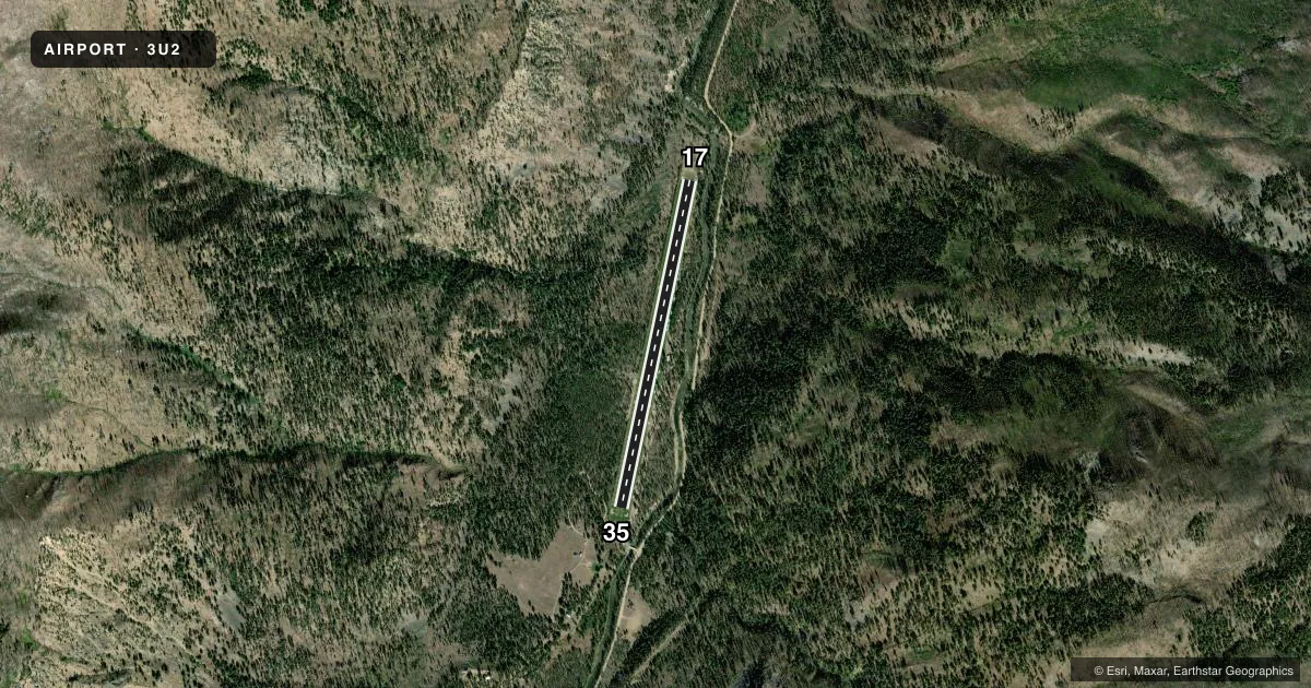
Runways & pattern
Full pagePattern entry · RWY 35
LEFT TRAFFICRunway end performance
| End | TORA | TODA | ASDA | LDA | VGSI | Approach lights | Obstruction |
|---|---|---|---|---|---|---|---|
| 17 | — | — | — | — | — | — | 40', trees, 25' from thr, 100' R of cntrln, slope 0 |
| 35 | — | — | — | — | — | — | 4', fence, 0' from thr, 100' R of cntrln, slope 0 |
Declared distances in feet. TORA = takeoff run available, TODA = takeoff distance, ASDA = accelerate-stop, LDA = landing distance.
Airport sketch
Runways drawn to scale from FAA survey coordinates, rendered over satellite imagery. Not for navigation.
Approaches & charts
Services on the field
Fuel grades, oxygen, maintenance, ramp storage and lighting — as declared to the FAA by the airport operator.
Fuel & services
- Fuel
- Not available
- Oxygen (bottled)
- Not available
- Oxygen (bulk)
- Not available
- Airframe repair
- Not available
- Power plant repair
- Not available
Ramp & ground
- Transient storage
- Tie-down
- Landing fee
- No fee published
- Wind indicator
- Yes
- Segmented circle
- Yes
Fuel & FBOs
Cheapest 100LL and Jet A on the field and nearby. Always confirm with the FBO before taxi.
Airport notes
Surface conditions, obstructions, local procedures, lighting outages and other notes published with each FAA cycle.
General notes
- ADDNL 100 FT OF LEN AVBL FOR TKOF ON RWY 35 END.
- NO WINTER MAINTENANCE.
- NUMEROUS +60' TREES ADJACENT TO EACH SIDE OF RY.
- BE ALERT FOR SPRINKLERS ON RY.
- RECOMMEND LAND RWY 17; TKOF RWY 35 WHEN WIND CONDITIONS ALLOW.
- BIG GAME ANIMALS ON & INVOF AIRPORT.
- SPECIAL CONSIDERATIONS SHOULD BE GIVEN TO DENSITY ALTITUDE, TURBULENCE, AND MOUNTAIN FLYING PROFICIENCY.
- FOR CD CTC SALT LAKE ARTCC AT 801-320-2568.
- TRRN CTN - 1500 FT RDG AT 4000 FT, 400 FT R (N OF RWY 17).
Approach & departure obstructions
- 1717/35 EDGES & THRS MARKED WITH WHITE ROCK BOUNDARY MARKERS.
- 17900 FT RIDGE 4000 FT ON CNTRLN; 4 FT FENCE 115 FT ON CNTRLN + 30-60 FT TREES 600 FT ON CNTRLN.
- 35HAS +110 FT TRRN & HOUSE 560 FT, 50 FT LEFT, 90 FT TRRN & TREES 450 FT ON CNTRLN; 60 FT TREES 330 FT ON CNTRLN; 20 FT TREE AT 100 FT ON CNTRLN.
Other notes
- ESTAB PRIOR TO OCT 1959.
- 1/2 SEGMENTED CIRCLE.
- 1CARETAKER IN ATTENDANCE DURG SUMMER MONTHS.
VFR map & nearby airports
VFR sectional. Tap any ICAO chip to open that airport.
Key facts · 3U2
Answer card- ICAO
- 3U2
- Name
- JOHNSON CREEK
- Location
- YELLOW PINE, IDAHO
- Elevation
- 4,960 ft MSL
- Traffic pattern altitude
- 5,960 ft MSL (1,000 AGL)
- Control tower
- Non-towered (use CTAF)
- Total runways
- 1
- Longest runway
- 17/35 · 3,400 ft
- Published ILS approaches
- 0
- Published frequencies
- 1
- Magnetic variation
- 17°
- Current flight rules
- VFR
- Current wind
- 360° at 4 kt
- Favored runway now
- RWY 35
Johnson Creek (3U2) sits near Yellow Pine, Idaho. The field elevation is 4,960 ft MSL. It has one runway. Runway 17/35 is 3,400 ft of turf. An extra 100 ft is available for takeoff from the runway 35 end. There is no control tower. CTAF is 122.9.
No ILS approaches are published here. Pattern altitude is not published, so use the standard 1,000 ft AGL for light piston operations unless the current FAA Chart Supplement says otherwise. That puts the pattern at about 5,960 ft MSL based on the listed field elevation. The published remarks matter here. Big game animals are a known hazard. Sprinklers may be on the runway. Terrain is close in. There is a ridge north of runway 17, plus trees and other obstructions near both ends. The airport also sits in mountain country, so density altitude, turbulence and mountain flying skill deserve attention.
No on-field FBOs are listed. Plan on self-sufficiency and verify current services with the airport operator or the FBO directly by phone before you go. The runway edges and thresholds are marked with white rock boundary markers. Published guidance recommends landing runway 17 and taking off runway 35 when wind allows. That is useful local advice for a first visit, especially with the terrain and obstacle picture here.