METAR & TAF ID8
ID8 does not publish a METAR.
Showing the nearest reporting station: KLLJ (CHALLIS) · 36.0 NM away. Conditions at ID8 may differ.
METAR · KLLJ
Observed 05:55Z
KLLJ 270555Z AUTO 22004KT 10SM OVC120 20/03 A3008 RMK AO2 SLP118 T02000033 10344 20194 51017 $
- Wind
- 220° @ 4 kt
- Visibility
- 10 SM
- Temp / Dew
- 20°C / 3°C
- Altimeter
- 30.08 inHg
- Clouds
- OVC
- Density alt
- 6,211 ft
- Ceiling
- 12,000 ft AGL
- Rules
- VFR
Airport info & contacts
Manager on record, flight service, ARTCC, attendance schedule and pattern altitude — published by the FAA and refreshed every 28 days.
Location
- From city
- 36 NM WNW
- VFR sectional
- GREAT FALLS
- ARTCC
- ZLC · SALT LAKE CITY
- NOTAM facility
- BOI (NOTAM-D)
Airport manager
- Name
- RYAN HILTON
- Phone
- 208-756-2271
- Address
- 99 HWY 93 N, SALMON ID 83467
Flight service · Hours
- FSS BOI
- BOISE1-800-WX-BRIEF
Frequencies
Tap any row to copy the frequency to your clipboard.
Runways & pattern
Full pagePattern entry · RWY 22
LEFT TRAFFICRunway end performance
| End | TORA | TODA | ASDA | LDA | VGSI | Approach lights | Obstruction |
|---|---|---|---|---|---|---|---|
| 04 | — | — | — | — | — | — | 50', hill, 600' from thr, 0' R of cntrln, slope 12 |
| 22 | — | — | — | — | — | — | 30', trees, 200' from thr, 0' R of cntrln, slope 6 |
Declared distances in feet. TORA = takeoff run available, TODA = takeoff distance, ASDA = accelerate-stop, LDA = landing distance.
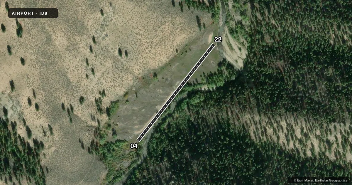
Airport sketch
Runways drawn to scale from FAA survey coordinates, rendered over satellite imagery. Not for navigation.
Approaches & charts
Services on the field
Fuel grades, oxygen, maintenance, ramp storage and lighting — as declared to the FAA by the airport operator.
Fuel & services
- Fuel
- Not available
Ramp & ground
- Transient storage
- Not published
Fuel & FBOs
Cheapest 100LL and Jet A on the field and nearby. Always confirm with the FBO before taxi.
Airport notes
Surface conditions, obstructions, local procedures, lighting outages and other notes published with each FAA cycle.
General notes
- WINTER MAINT NA.
- USE AT OWN RISK; RWY SHORT & CHALLENGING; OPS BY ENVIRONMENT EQUIPPED EXPERIENCED TRAINED BACKCOUNTRY PILOTS RCMDD.
- FOR CD CTC SALT LAKE ARTCC AT 1-801-320-2568.
- WILDLIFE & LIVESTOCK ON & INVOF OF RWY.
- HIGH DENSITY ALT; ERY MRNG & LATE EVE OPS RCMD DURG SUMMER MONTHS - AMGR.
- ARPT IN CANYON; TIMBERED HIGH MT TRRN ALL QUADS.
Runway surface & condition
- 04/22TRRN & TREES IN APCH AREA BOTH ENDS.
Other notes
- 04/22NE END FIRST 400FT SOFT SAND.
VFR map & nearby airports
VFR sectional. Tap any ICAO chip to open that airport.
Key facts · ID8
Answer card- ICAO
- ID8
- Name
- MARBLE CREEK
- Location
- CHALLIS, IDAHO
- Elevation
- 4,685 ft MSL
- Traffic pattern altitude
- 5,685 ft MSL (1,000 AGL)
- Control tower
- Non-towered (use CTAF)
- Total runways
- 1
- Longest runway
- 04/22 · 1,160 ft
- Published ILS approaches
- 0
- Published frequencies
- 1
- Magnetic variation
- –
- Current flight rules
- VFR
- Current wind
- 220° at 4 kt
- Favored runway now
- RWY 22
Marble Creek Airport (ID8) is near Challis, Idaho. The field elevation is 4,685 ft MSL. It has one runway, 04/22, which is 1,160 ft long and surfaced with dirt-turf. There is no control tower. CTAF is 122.9. No ILS approaches are published.
The pattern altitude is not published. Use standard 1,000 ft AGL for light piston operations unless the current FAA Chart Supplement says otherwise. This is a canyon airport with timbered high mountain terrain in all quadrants. The runway is short. Terrain and trees are in the approach area at both ends. The first 400 ft at the northeast end of the runway is soft sand. Wildlife and livestock may be on or near the runway.
High density altitude is a real factor here. Summer departures and arrivals are better planned for early morning or late evening. The airport is recommended for experienced backcountry pilots with well-equipped aircraft. Winter maintenance is not available. There are no on-field FBOs listed. For clearance delivery, contact Salt Lake ARTCC at 1-801-320-2568.