METAR & TAF D47
D47 does not publish a METAR.
Showing the nearest reporting station: KLLJ (CHALLIS) · 32.7 NM away. Conditions at D47 may differ.
METAR · KLLJ
Observed 12:55Z
KLLJ 271255Z AUTO 00000KT 9SM CLR 14/03 A3014 RMK AO2 SLP134 T01390033 $
- Wind
- 000° @ 0 kt
- Visibility
- 9 SM
- Temp / Dew
- 14°C / 3°C
- Altimeter
- 30.14 inHg
- Clouds
- CLR
- Density alt
- 4,911 ft
- Ceiling
- Unlimited
- Rules
- VFR
Airport info & contacts
Manager on record, flight service, ARTCC, attendance schedule and pattern altitude — published by the FAA and refreshed every 28 days.
Location
- From city
- 33 NM NW
- VFR sectional
- GREAT FALLS
- ARTCC
- ZLC · SALT LAKE CITY
- NOTAM facility
- BOI (NOTAM-D)
Airport manager
- Name
- TOM CURET
- Phone
- 208 756 2271
- Address
- 99 HIGHWAY 93 N, SALMON ID 83467
Flight service · Hours
- FSS BOI
- BOISE1-800-WX-BRIEF
Frequencies
Tap any row to copy the frequency to your clipboard.
Runways & pattern
Full pagePattern entry · RWY 02
LEFT TRAFFICRunway end performance
| End | TORA | TODA | ASDA | LDA | VGSI | Approach lights | Obstruction |
|---|---|---|---|---|---|---|---|
| 02 | — | — | — | — | — | — | 6', other, 20' from thr, 15' R of cntrln, slope 3 |
| 20 | — | — | — | — | — | — | 65', tree, 550' from thr, 150' R of cntrln, slope 8 |
Declared distances in feet. TORA = takeoff run available, TODA = takeoff distance, ASDA = accelerate-stop, LDA = landing distance.
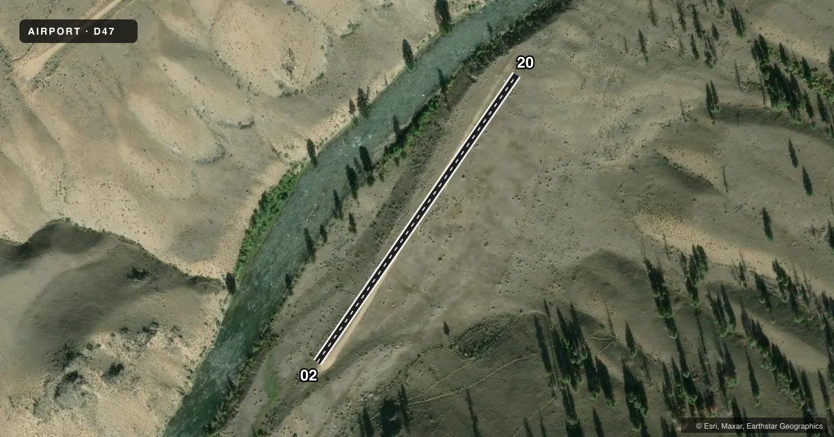
Airport sketch
Runways drawn to scale from FAA survey coordinates, rendered over satellite imagery. Not for navigation.
Approaches & charts
Services on the field
Fuel grades, oxygen, maintenance, ramp storage and lighting — as declared to the FAA by the airport operator.
Fuel & services
- Fuel
- Not available
Ramp & ground
- Transient storage
- Not published
- Wind indicator
- Yes
- Segmented circle
- Yes
Fuel & FBOs
Cheapest 100LL and Jet A on the field and nearby. Always confirm with the FBO before taxi.
Airport notes
Surface conditions, obstructions, local procedures, lighting outages and other notes published with each FAA cycle.
General notes
- OWNER DESIRES AP BE CHARTED.
- NO WINT MAINT.
- RCMD FOR USE ONLY BY EXPERIENCED PILOTS. EARLY MRNG & LATE EVE OPS DURG SUMMER MONTHS.
- RCMD LDG RWY 20 & TKOF RWY 02 IF WND CONDS ALLOW.
- BE AWARE OF INBD AND OBND TFC TO THE W AT NEIGHBORING MAHONEY CREEK USFS AIRPORT (0U3).
Approach & departure obstructions
- 20RWY END HAS 150 FT OVRN FM BDRY MKRS & TRMTS WITH ABRUPT 125 FT DROP OFF DOWN TO RIVER.
- 02RWY 02/20 THR EDGES MKD WITH W ROCK BNDRY MKRS.
- 02RWY 02 CTLG OBSTN IS 6 FT 4 X 4 IN WOOD POST AT 20 FT & 15 R.
- 20RWY 20 BE AWARE OF RISING TRRNN TO THE N - A +200 FT RIDGE LN AT 2250 FT ON CNTRLN.
Other notes
- NON-STD SEGMENTED CRC.
- 02/20RWY 02/20 HAS A FAIR SFC COND, IT IS VERY SHRT (1400 FT) & THE LAST 200 FT(RWY END 02) HAS A DOG LEG TWD THE RIVER.
VFR map & nearby airports
VFR sectional. Tap any ICAO chip to open that airport.
Key facts · D47
Answer card- ICAO
- D47
- Name
- COUGAR RANCH
- Location
- CHALLIS, IDAHO
- Elevation
- 4,277 ft MSL
- Traffic pattern altitude
- 5,277 ft MSL (1,000 AGL)
- Control tower
- Non-towered (use CTAF)
- Total runways
- 1
- Longest runway
- 02/20 · 1,400 ft
- Published ILS approaches
- 0
- Published frequencies
- 1
- Magnetic variation
- –
- Current flight rules
- VFR
- Current wind
- 000° at 0 kt
- Favored runway now
- –
Cougar Ranch (D47) is in Challis, Idaho. The field elevation is 4,277 ft MSL. It has one runway, 02/20, which is 1,400 ft long and surfaced with dirt. There is no control tower. CTAF is 122.9. No ILS approaches are published.
The pattern altitude is not published. Use the standard 1,000 ft AGL pattern unless the current FAA Chart Supplement says otherwise. This is a short backcountry-style strip. The published remarks say it is recommended for experienced pilots only. Summer traffic can be active in the early morning and late evening. Runway 20 is the preferred landing runway if wind allows. Runway 02 is the preferred departure runway if wind allows.
The runway has some specific hazards. Runway 20 has 150 ft of overrun from the boundary markers. There is then an abrupt 125 ft drop to the river. Runway 20 also has rising terrain to the north. A ridge line about 200 ft high is located 2,250 ft on centerline. Runway 02 has a wood post obstruction 20 ft high and 15 ft right of centerline. The last 200 ft of runway 02 has a dog leg toward the river. There is no winter maintenance. No on-field FBOs are listed. Check the current FAA Chart Supplement and call the airport operator before you go.