METAR & TAF U88
U88 does not publish a METAR.
Showing the nearest reporting station: KBOI (BOISE AIR TRML/GOWEN FLD) · 32.7 NM away. Conditions at U88 may differ.
METAR · KBOI
Observed 22:01Z
KBOI 262201Z 32008KT 3SM FU OVC035 32/09 A2997 RMK AO2 T03170089 $
- Wind
- 320° @ 8 kt
- Visibility
- 3 SM
- Temp / Dew
- 32°C / 9°C
- Altimeter
- 29.97 inHg
- Clouds
- OVC
- Density alt
- 5,917 ft
- Ceiling
- 3,500 ft AGL
- Rules
- MVFR
Airport info & contacts
Manager on record, flight service, ARTCC, attendance schedule and pattern altitude — published by the FAA and refreshed every 28 days.
Location
- From city
- 2 NM SE
- VFR sectional
- SALT LAKE CITY
- ARTCC
- ZLC · SALT LAKE CITY
- NOTAM facility
- BOI (NOTAM-D)
Airport manager
- Name
- IDAHO DIV. OF AERONAUTICS
- Phone
- 208-334-8775
- Address
- P.O. BOX 7129, BOISE ID 83707-1129
Flight service · Hours
- FSS BOI
- BOISE1-800-WX-BRIEF
- Attendance
- Unattended
Frequencies
Tap any row to copy the frequency to your clipboard.
Runways & pattern
Full pagePattern entry · RWY 28
LEFT TRAFFICRunway end performance
| End | TORA | TODA | ASDA | LDA | VGSI | Approach lights | Obstruction |
|---|---|---|---|---|---|---|---|
| 10 | — | — | — | — | — | — | 4', fence, 0' from thr, 80' R of cntrln, slope 0 |
| 28 | — | — | — | — | — | — | 4', fence, 0' from thr, 65' R of cntrln, slope 0 |
Declared distances in feet. TORA = takeoff run available, TODA = takeoff distance, ASDA = accelerate-stop, LDA = landing distance.
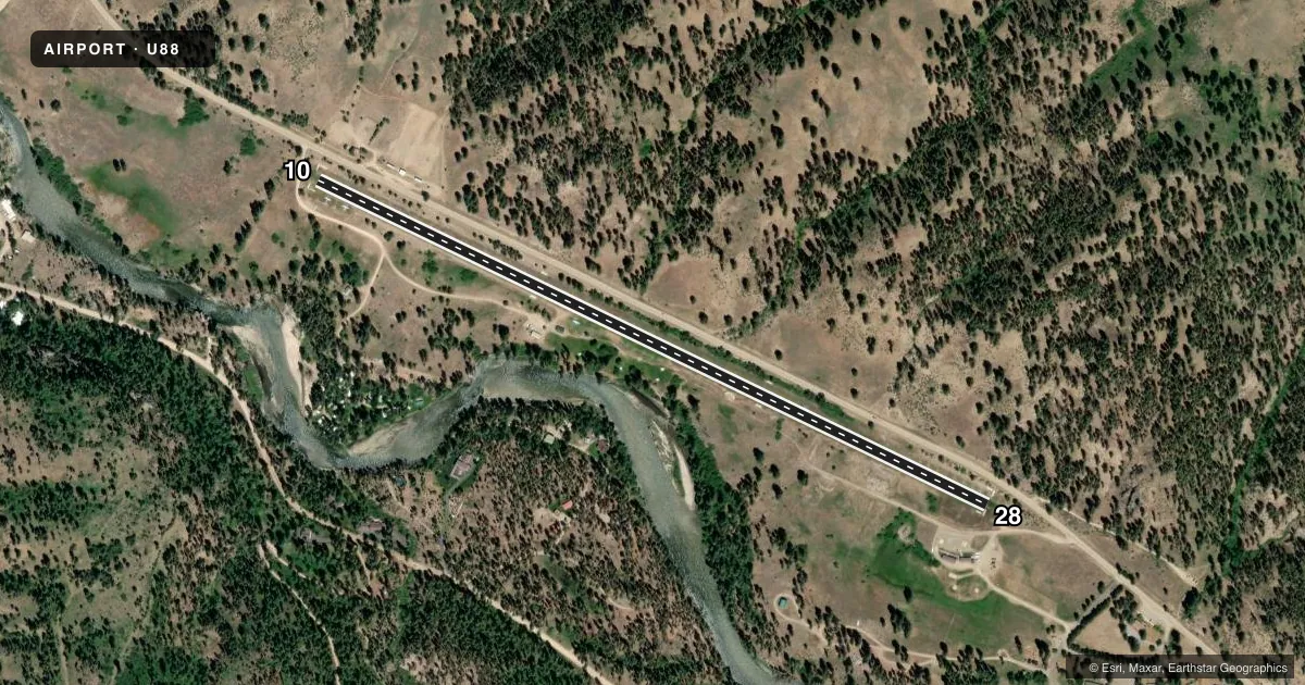
Airport sketch
Runways drawn to scale from FAA survey coordinates, rendered over satellite imagery. Not for navigation.
Approaches & charts
Services on the field
Fuel grades, oxygen, maintenance, ramp storage and lighting — as declared to the FAA by the airport operator.
Fuel & services
- Fuel
- Not available
- Oxygen (bottled)
- Not available
- Oxygen (bulk)
- Not available
- Airframe repair
- Not available
- Power plant repair
- Not available
Ramp & ground
- Transient storage
- Tie-down
- Landing fee
- No fee published
- Customs
- Not available
- Wind indicator
- Yes
- Segmented circle
- Yes
Fuel & FBOs
Cheapest 100LL and Jet A on the field and nearby. Always confirm with the FBO before taxi.
Airport notes
Surface conditions, obstructions, local procedures, lighting outages and other notes published with each FAA cycle.
General notes
- NO WINTER MAINTENANCE.
- NO TELEPHONE AVBL AT ARPT.
- WATCH FOR SPRINKLER HEADS ON RY.
- ARPT LCTD IN MTN VALLEY.
- NMRS ADDNL OBSTNS ON APCH ENDS OF BOTH RWYS - MTN RIDGES AND TREES. 30 FT TO 50 FT TREES ON BOTH EDGES OF RWY.
- USFS HELI OPS ADJ TO SE END OF ARPT.
Runway surface & condition
- 10/28RCMD LANDING RWY 10; TAKE-OFF RWY 28 IF WINDS ALLOW.
Approach & departure obstructions
- 1010/28 EDGES & THLDS MARKED WITH WHITE ROCKS.
Other notes
- NONCOMPLIANCE WITH FAR PART 157.
- 1/2 SEGMENTED CIRCLE.
VFR map & nearby airports
VFR sectional. Tap any ICAO chip to open that airport.
Key facts · U88
Answer card- ICAO
- U88
- Name
- GARDEN VALLEY
- Location
- GARDEN VALLEY, IDAHO
- Elevation
- 3,177 ft MSL
- Traffic pattern altitude
- 4,177 ft MSL (1,000 AGL)
- Control tower
- Non-towered (use CTAF)
- Total runways
- 1
- Longest runway
- 10/28 · 3,850 ft
- Published ILS approaches
- 0
- Published frequencies
- 1
- Magnetic variation
- 17°
- Current flight rules
- MVFR
- Current wind
- 320° at 8 kt
- Favored runway now
- RWY 28
Garden Valley Airport sits in Garden Valley, Idaho. The field elevation is 3,177 ft MSL. It has one runway, 10/28, which is 3,850 ft long and surfaced with turf. There is no control tower. CTAF is 122.9. No ILS approaches are published.
Pattern altitude is not published. Use the standard 1,000 ft AGL pattern unless the current FAA Chart Supplement says otherwise. The airport is in a mountain valley. Expect terrain to matter on arrival and departure. Published remarks call out mountain ridges and trees near both approach ends. Trees 30 ft to 50 ft tall also line both edges of the runway. Watch for sprinkler heads on the runway. There is no winter maintenance, so surface condition can change fast.
The recommended landing runway is 10 if winds allow. The recommended takeoff runway is 28 if winds allow. The runway edges and thresholds are marked with white rocks. United States Forest Service helicopter operations are adjacent to the southeast end of the airport. There are no on-field FBOs listed, so plan to verify services with the airport operator or by calling the field before you go. This is a good airport to brief carefully before a first visit, especially with the valley terrain and the lack of published ILS support.