METAR & TAF 0U8
0U8 does not publish a METAR.
Showing the nearest reporting station: KLLJ (CHALLIS) · 14.8 NM away. Conditions at 0U8 may differ.
METAR · KLLJ
Observed 09:55Z
KLLJ 270955Z AUTO 14003KT 10SM BKN065 BKN080 17/03 A3011 RMK AO2 SLP114 T01670028 $
- Wind
- 140° @ 3 kt
- Visibility
- 10 SM
- Temp / Dew
- 17°C / 3°C
- Altimeter
- 30.11 inHg
- Clouds
- BKN
- Density alt
- 6,606 ft
- Ceiling
- 6,500 ft AGL
- Rules
- VFR
Airport info & contacts
Manager on record, flight service, ARTCC, attendance schedule and pattern altitude — published by the FAA and refreshed every 28 days.
Location
- From city
- 1 NM NE
- VFR sectional
- GREAT FALLS
- ARTCC
- ZLC · SALT LAKE CITY
- NOTAM facility
- BOI (NOTAM-D)
Airport manager
- Name
- DIV OF AERONAUTICS
- Phone
- 208-334-8775
- Address
- P.O. BOX 7129, BOISE ID 83707-1129
Flight service · Hours
- FSS BOI
- BOISE1-800-WX-BRIEF
- Attendance
- Unattended
Frequencies
Tap any row to copy the frequency to your clipboard.
Runways & pattern
Full pagePattern entry · RWY 09
LEFT TRAFFICRunway end performance
| End | TORA | TODA | ASDA | LDA | VGSI | Approach lights | Obstruction |
|---|---|---|---|---|---|---|---|
| 09 | — | — | — | — | — | — | 45', pole, 600' from thr, 150' R of cntrln, slope 13 |
| 27 | — | — | — | — | — | — | 4', fence, 0' from thr, 110' R of cntrln, slope 0 |
Declared distances in feet. TORA = takeoff run available, TODA = takeoff distance, ASDA = accelerate-stop, LDA = landing distance.
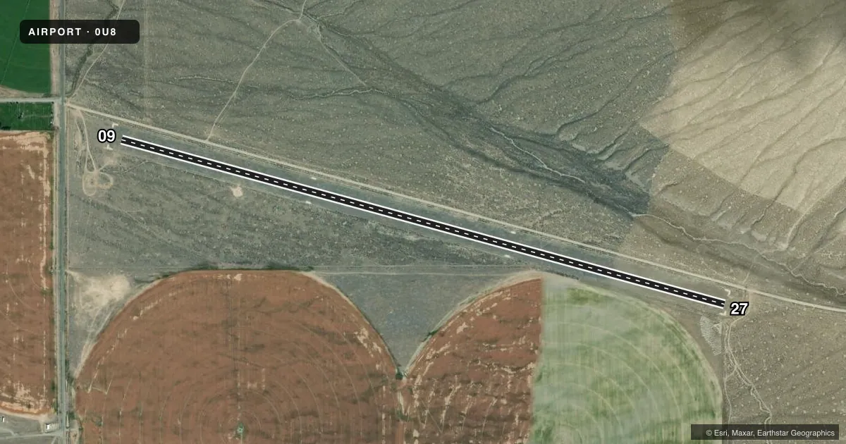
Airport sketch
Runways drawn to scale from FAA survey coordinates, rendered over satellite imagery. Not for navigation.
Approaches & charts
Services on the field
Fuel grades, oxygen, maintenance, ramp storage and lighting — as declared to the FAA by the airport operator.
Fuel & services
- Fuel
- Not available
- Oxygen (bottled)
- Not available
- Oxygen (bulk)
- Not available
- Airframe repair
- Not available
- Power plant repair
- Not available
Ramp & ground
- Transient storage
- Tie-down
- Landing fee
- No fee published
- Customs
- Not available
- Wind indicator
- Yes
- Segmented circle
- Yes
Fuel & FBOs
Cheapest 100LL and Jet A on the field and nearby. Always confirm with the FBO before taxi.
Airport notes
Surface conditions, obstructions, local procedures, lighting outages and other notes published with each FAA cycle.
General notes
- NO WINTER MAINT.
- -2 FT DITCH ADJACENT TO BOTH EDGES OF RY & THRS.
- ARPT LCTD IN HIGH MTN VALLEY SURROUNDED BY HIGH TERRAIN.
- RECOMMEND LANDING RY 09; TKOFF RY 27 WHEN WIND CONDITIONS PERMIT.
- ARPT SUBJECT TO CONTINUOUS DAMAGE BY GROUND VEHICLES; LIVESTOCK & RODENTS.
- FENCE MARKER LOCATED ON APPROACH END OF RY 27.
- FOR CD CTC SALT LAKE ARTCC AT 801-320-2568.
Approach & departure obstructions
- 09RWY 09/27 EDGES & THRS MARKED WITH W ROCKS BDRY MARKERS.
- 09+45 FT POLE AT 600 FT, 150 FT L.
- 27+4 FT FENCE 125 FT ON CNTRLN.
Other notes
- ESTABD PRIOR TO 15 MAY 1959.
VFR map & nearby airports
VFR sectional. Tap any ICAO chip to open that airport.
Key facts · 0U8
Answer card- ICAO
- 0U8
- Name
- MAY
- Location
- MAY, IDAHO
- Elevation
- 5,324 ft MSL
- Traffic pattern altitude
- 6,324 ft MSL (1,000 AGL)
- Control tower
- Non-towered (use CTAF)
- Total runways
- 1
- Longest runway
- 09/27 · 4,950 ft
- Published ILS approaches
- 0
- Published frequencies
- 1
- Magnetic variation
- 17°
- Current flight rules
- VFR
- Current wind
- 140° at 3 kt
- Favored runway now
- RWY 09
MAY Airport (0U8) sits in MAY, Idaho at 5,324 ft MSL. It has one runway. Runway 09/27 is 4,950 ft of turf. There is no control tower. CTAF is 122.9. No ILS approaches are published here.
The pattern altitude is not published. Use the standard 1,000 ft AGL for light piston operations unless the current Chart Supplement says otherwise. The airport is in a high mountain valley surrounded by high terrain. That matters here. Expect density altitude to be a real factor on warm days. Performance planning should be conservative.
Published remarks point to a few things a first-time pilot should know. There is a 2 ft ditch along both edges of the runway and at the thresholds. White rock markers outline the runway edges and thresholds. A 45 ft pole sits about 600 ft from runway 09, 150 ft left of centerline. A 4 ft fence is on the centerline about 125 ft from runway 27. The field also has no winter maintenance. The published recommendation is to land runway 09 and take off runway 27 when wind conditions permit. No on-field FBOs are listed, so verify services with the airport operator or the FBO directly by phone before you go.