METAR & TAF 4D2
4D2 does not publish a METAR.
Showing the nearest reporting station: KSMN (LEMHI COUNTY) · 29.0 NM away. Conditions at 4D2 may differ.
METAR · KSMN
Observed 05:56Z
KSMN 270556Z AUTO 23003KT 9SM SCT095 22/04 A3000 RMK AO2 SLP119 T02170044 10361 20206 51021
- Wind
- 230° @ 3 kt
- Visibility
- 9 SM
- Temp / Dew
- 22°C / 4°C
- Altimeter
- 30.00 inHg
- Clouds
- SCT
- Density alt
- 10,986 ft
- Ceiling
- Unlimited
- Rules
- VFR
Airport info & contacts
Manager on record, flight service, ARTCC, attendance schedule and pattern altitude — published by the FAA and refreshed every 28 days.
Location
- From city
- 30 NM W
- VFR sectional
- GREAT FALLS
- ARTCC
- ZLC · SALT LAKE CITY
- NOTAM facility
- BOI (NOTAM-D)
Airport manager
- Name
- IDAHO DIVISION OF AERONAUTICS
- Phone
- 208-484-1521
- Address
- 1390 W GOWEN RD, BOISE ID 83705
Flight service · Hours
- FSS BOI
- BOISE1-800-WX-BRIEF
- Attendance
- Unattended
Frequencies
Tap any row to copy the frequency to your clipboard.
Runways & pattern
Full pagePattern entry · RWY 21
RIGHT TRAFFICRunway end performance
| End | TORA | TODA | ASDA | LDA | VGSI | Approach lights | Obstruction |
|---|---|---|---|---|---|---|---|
| 03 | — | — | — | — | — | — | 30', trees, 20' from thr, 80' R of cntrln, slope 0 |
| 21 | — | — | — | — | — | — | 55', trees, 35' from thr, 60' R of cntrln, slope 0 |
Declared distances in feet. TORA = takeoff run available, TODA = takeoff distance, ASDA = accelerate-stop, LDA = landing distance.
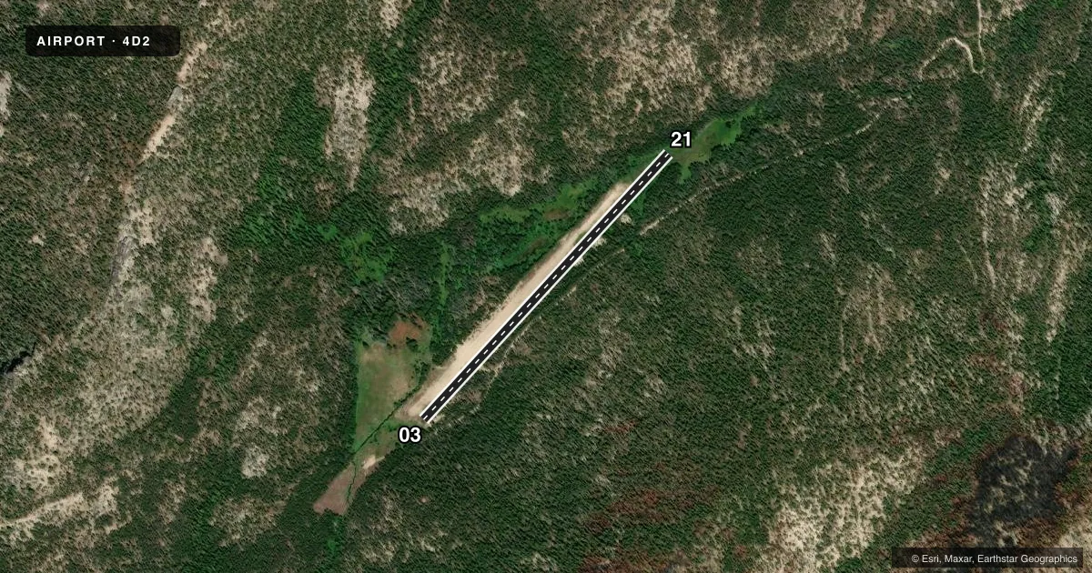
Airport sketch
Runways drawn to scale from FAA survey coordinates, rendered over satellite imagery. Not for navigation.
Approaches & charts
Services on the field
Fuel grades, oxygen, maintenance, ramp storage and lighting — as declared to the FAA by the airport operator.
Fuel & services
- Fuel
- Not available
Ramp & ground
- Transient storage
- Not published
- Wind indicator
- Yes
- Segmented circle
- No
Fuel & FBOs
Cheapest 100LL and Jet A on the field and nearby. Always confirm with the FBO before taxi.
Airport notes
Surface conditions, obstructions, local procedures, lighting outages and other notes published with each FAA cycle.
General notes
- REQ USE ONLY BY MT PROFICIENT PILOTS.
- CK ACFT PER FOR HIGH DENSITY ALT (DA).
- NO WINTER MAINT.
- REQ LAND RWY 3 AND TKOF RWY 21 IF WX CONDS ALLOW.
- BE AWARE OF SOFT SPOT LCTG JUST PAST THE MID-FLD, RIGHT SIDE OF RWY 3, AND STUMPS LCT AT BOTH RWY ENDS.
- AIRFIELD LCTD IN HIGH MT VALLEY & SRNDD BY TIMBERED, HIGH MT PEAKS. THIS IS THE HIGHEST ELEV BACKCOUNTRY AIRFIELD IN IDAHO - 8250 FT MSL.
- OVERFLY THE AIRFIELD FST AND ENSURE NO WILDLIFE IS ON THE RWY.
Runway surface & condition
- 03/21ACTUAL RWY DIMENSIONS ARE: 1900 FT X 55 FT.
Approach & departure obstructions
- 03CTLG OBSTN IS A PATCH OF TREES 30 FT TALL AT 20 FT, 80 FT LEFT AND TREES 55 FT TALL AT 35 FT, 60 FT LEFT.
Other notes
- 03/21DIRT & GRVL
VFR map & nearby airports
VFR sectional. Tap any ICAO chip to open that airport.
Key facts · 4D2
Answer card- ICAO
- 4D2
- Name
- HOODOO MEADOWS
- Location
- SALMON, IDAHO
- Elevation
- 8,262 ft MSL
- Traffic pattern altitude
- 9,262 ft MSL (1,000 AGL)
- Control tower
- Non-towered (use CTAF)
- Total runways
- 1
- Longest runway
- 03/21 · 2,200 ft
- Published ILS approaches
- 0
- Published frequencies
- 1
- Magnetic variation
- –
- Current flight rules
- VFR
- Current wind
- 230° at 3 kt
- Favored runway now
- RWY 21
Hoodoo Meadows is in Salmon, Idaho. The field elevation is 8,262 ft MSL. It has one runway. The listed runway is 03/21 at 2,200 ft, with actual runway dimensions published as 1,900 ft by 55 ft. There is no control tower. CTAF is 122.9. No ILS approaches are published.
Pattern altitude is not published. Use the standard 1,000 ft AGL pattern for light piston operations unless the current Chart Supplement or local procedures say otherwise. This is a high mountain valley field surrounded by timbered peaks. Density altitude is a real factor here. Performance planning matters before you launch.
The runway surface is dirt and gravel. Published remarks call out a soft spot just past midfield on the right side of runway 3. Stumps are also reported at both runway ends. Trees are charted near runway 03. The field is used only by mountain proficient pilots. There is no winter maintenance. The remarks also say to overfly the field fast and confirm the runway is clear of wildlife before landing. Landing is required on runway 3 and takeoff on runway 21 if weather allows. No on-field FBOs are listed, so verify services with the airport operator or the FBO directly by phone before you go.