METAR & TAF U81
U81 does not publish a METAR.
Showing the nearest reporting station: KSMN (LEMHI COUNTY) · 46.1 NM away. Conditions at U81 may differ.
METAR · KSMN
Observed 05:56Z
KSMN 270556Z AUTO 23003KT 9SM SCT095 22/04 A3000 RMK AO2 SLP119 T02170044 10361 20206 51021
- Wind
- 230° @ 3 kt
- Visibility
- 9 SM
- Temp / Dew
- 22°C / 4°C
- Altimeter
- 30.00 inHg
- Clouds
- SCT
- Density alt
- 9,458 ft
- Ceiling
- Unlimited
- Rules
- VFR
Airport info & contacts
Manager on record, flight service, ARTCC, attendance schedule and pattern altitude — published by the FAA and refreshed every 28 days.
Location
- From city
- 0 NM NW
- VFR sectional
- GREAT FALLS
- ARTCC
- ZLC · SALT LAKE CITY
- NOTAM facility
- BOI (NOTAM-D)
Airport manager
- Name
- KRASSEL DISTRICT RANGER
- Phone
- 208-634-0600
- Address
- 500 NORTH MISSION ST., MC CALL ID 83638
Flight service · Hours
- FSS BOI
- BOISE1-800-WX-BRIEF
- Attendance
- Unattended
Frequencies
Tap any row to copy the frequency to your clipboard.
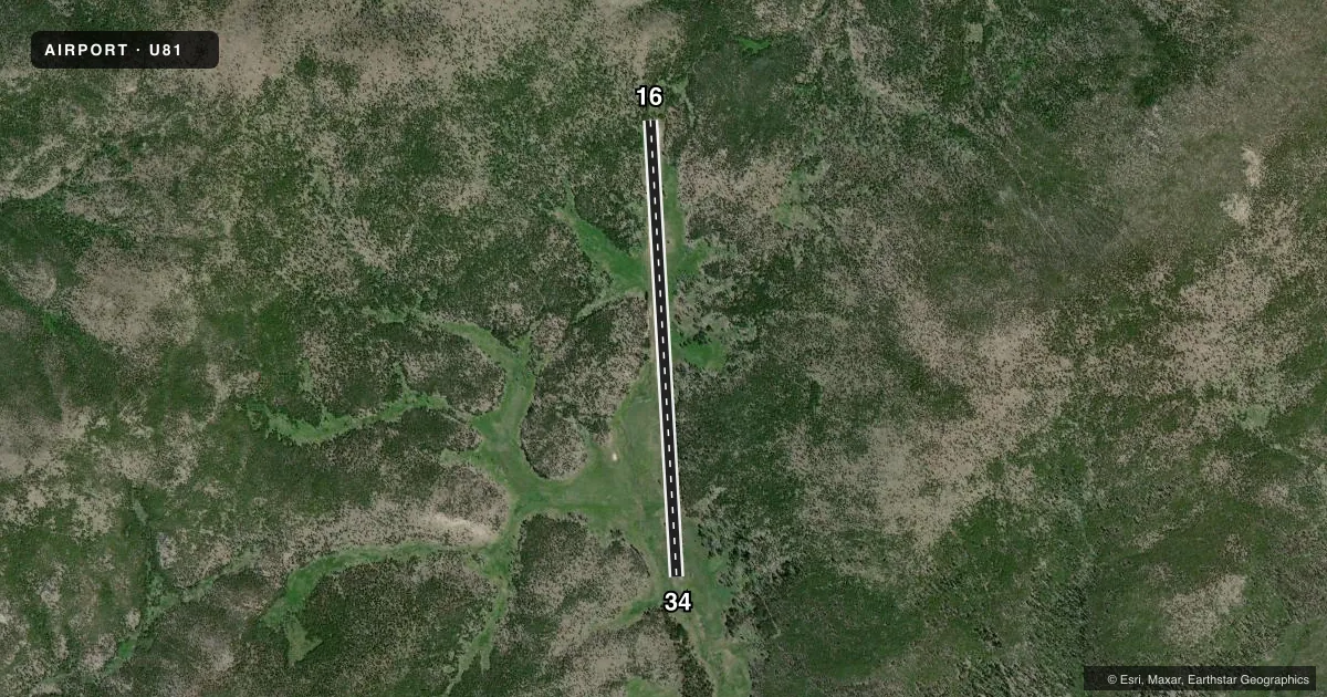
Runways & pattern
Full pagePattern entry · RWY 16
LEFT TRAFFICRunway end performance
| End | TORA | TODA | ASDA | LDA | VGSI | Approach lights | Obstruction |
|---|---|---|---|---|---|---|---|
| 16 | — | — | — | — | — | — | 35', trees, 0' from thr, 0' R of cntrln, slope 0 |
| 34 | — | — | — | — | — | — | 130', hill, 450' from thr, 0' R of cntrln, slope 3 |
Declared distances in feet. TORA = takeoff run available, TODA = takeoff distance, ASDA = accelerate-stop, LDA = landing distance.
Airport sketch
Runways drawn to scale from FAA survey coordinates, rendered over satellite imagery. Not for navigation.
Approaches & charts
Services on the field
Fuel grades, oxygen, maintenance, ramp storage and lighting — as declared to the FAA by the airport operator.
Fuel & services
- Fuel
- Not available
- Oxygen (bottled)
- Not available
- Oxygen (bulk)
- Not available
- Airframe repair
- Not available
- Power plant repair
- Not available
Ramp & ground
- Transient storage
- Tie-down
- Landing fee
- No fee published
- Wind indicator
- Yes
- Segmented circle
- Yes
Fuel & FBOs
Cheapest 100LL and Jet A on the field and nearby. Always confirm with the FBO before taxi.
Airport notes
Surface conditions, obstructions, local procedures, lighting outages and other notes published with each FAA cycle.
General notes
- NO WINTER MAINTENANCE.
- VERY HIGH DENSITY ALT FACTOR DURING SUMMER MONTHS.
- RODENT ACTIVITY ON AND INVOF ARPT.
- BE ADVISED USFS RECOMMENDS LEFT TURNOUT DOWN COTTON WOOD CREEK AFTER DEPARTING RY 16.
- NO TELEPHONE AVBL AT ARPT.
- RY MAY BE SOFT IN EARLY SPRING.
- RUBBER WATER BAR STRIPS ON RY.
- BIG GAME ANIMALS AND LIVESTOCK ON & INVOF RY.
- FOR CD CTC SALT LAKE ARTCC AT 801-320-2568.
Runway surface & condition
- 16/34WHEN WIND CONDS PERMIT LND RWY 34; DEP RWY 16.
- 16/34RWY 16/34 FIRST 500 FT OF RWY 34 VERY ROUGH.
Approach & departure obstructions
- 16UNPAINTED ROCK BDRY MKRS.
- 16A WALL OF 35 FT+ TALL TREES LCTD AT 0 FT ON CNTRLN.
- 16RWY 16 +35 FT TREES AT 10 FT ON CNTRLN; +30 FT TREES AT 5 FT 50 FT LEFT.
- 34125 FT TIMBERED RIDGE AT 350 FT & 200 FT LEFT.
Other notes
- ESTABD PRIOR TO 31 DEC 1958.
- 16/34ONLY 20 FT - CTR PTN OF RWY LEN IS DIRT & USED FOR TKOF & LDG.
VFR map & nearby airports
VFR sectional. Tap any ICAO chip to open that airport.
Key facts · U81
Answer card- ICAO
- U81
- Name
- COLD MEADOWS USFS
- Location
- COLD MEADOWS GUARD STATION, IDAHO
- Elevation
- 7,030 ft MSL
- Traffic pattern altitude
- 8,030 ft MSL (1,000 AGL)
- Control tower
- Non-towered (use CTAF)
- Total runways
- 1
- Longest runway
- 16/34 · 4,550 ft
- Published ILS approaches
- 0
- Published frequencies
- 1
- Magnetic variation
- 17°
- Current flight rules
- VFR
- Current wind
- 230° at 3 kt
- Favored runway now
- RWY 16
COLD MEADOWS USFS (U81) sits at the Cold Meadows Guard Station in Idaho. Field elevation is 7,030 ft MSL. The airport has one runway. Runway 16/34 is 4,550 ft long with a turf-dirt surface. The airport is not towered. CTAF is 122.9. No ILS approaches are published here.
Pattern altitude is not published. Use 1,000 ft AGL as the standard light-piston reference unless the current FAA Chart Supplement says otherwise. That puts the pattern at about 8,030 ft MSL. The field has no on-field FBOs listed. No fuel provider is confirmed on the field. Plan accordingly before you go.
This is a high-elevation backcountry strip. Summer density altitude can be a real factor. The published remarks also call out no winter maintenance. The runway may be soft in early spring. Runway 16 has trees close to the centerline near the departure end. The first 500 ft of runway 34 is very rough. The Forest Service also recommends a left turnout down Cotton Wood Creek after departing runway 16. Expect a strip that rewards a careful performance check, a conservative go-around plan and good short-field technique.