METAR & TAF U00
U00 does not publish a METAR.
Showing the nearest reporting station: KSMN (LEMHI COUNTY) · 35.2 NM away. Conditions at U00 may differ.
METAR · KSMN
Observed 17:56Z
KSMN 261756Z AUTO 00000KT 10SM CLR 26/07 A3007 RMK AO2 SLP139 T02560067 10256 20111 58013
- Wind
- 000° @ 0 kt
- Visibility
- 10 SM
- Temp / Dew
- 26°C / 7°C
- Altimeter
- 30.07 inHg
- Clouds
- CLR
- Density alt
- 8,610 ft
- Ceiling
- Unlimited
- Rules
- VFR
Airport info & contacts
Manager on record, flight service, ARTCC, attendance schedule and pattern altitude — published by the FAA and refreshed every 28 days.
Location
- From city
- 0 NM S
- VFR sectional
- GREAT FALLS
- ARTCC
- ZLC · SALT LAKE CITY
- NOTAM facility
- BOI (NOTAM-D)
Airport manager
- Name
- CHARLES LAMOURE
- Phone
- 208-940-2171
- Address
- 206 COURT HOUSE DR, SALMON ID 83467
Flight service · Hours
- FSS BOI
- BOISE1-800-WX-BRIEF
- Attendance
- Unattended
Frequencies
Tap any row to copy the frequency to your clipboard.
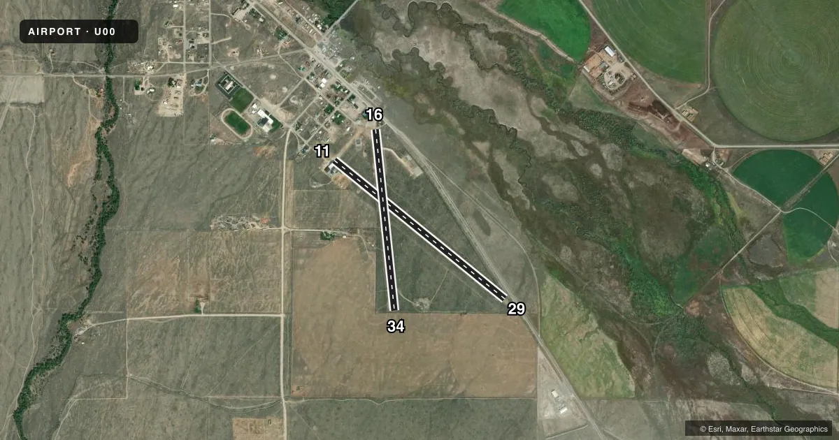
Runways & pattern
Full pagePattern entry · RWY 11
LEFT TRAFFIC| Runway | Heading (°M) | Length | Surface | Traffic |
|---|---|---|---|---|
| 11/29 | 112° / 292° | 3,500 ft | GRVL-DIRT | Standard L |
| 16/34 | 157° / 337° | 2,903 ft | TURF | Standard L |
Runway end performance
| End | TORA | TODA | ASDA | LDA | VGSI | Approach lights | Obstruction |
|---|---|---|---|---|---|---|---|
| 11 | — | — | — | — | — | — | 35', pole, 450' from thr, 100' R of cntrln, slope 12 |
| 29 | — | — | — | — | — | — | 4', fence, 0' from thr, 75' R of cntrln, slope 0 |
| 16 | — | — | — | — | — | — | 30', pole, 50' from thr, 120' R of cntrln, slope 1 |
| 34 | — | — | — | — | — | — | 5', fence, 20' from thr, 0' R of cntrln, slope 4 |
Declared distances in feet. TORA = takeoff run available, TODA = takeoff distance, ASDA = accelerate-stop, LDA = landing distance.
Airport sketch
Runways drawn to scale from FAA survey coordinates, rendered over satellite imagery. Not for navigation.
Approaches & charts
Services on the field
Fuel grades, oxygen, maintenance, ramp storage and lighting — as declared to the FAA by the airport operator.
Fuel & services
- Fuel
- Not available
- Oxygen (bottled)
- Not available
- Oxygen (bulk)
- Not available
- Airframe repair
- Not available
- Power plant repair
- Not available
Ramp & ground
- Transient storage
- Tie-down
- Landing fee
- No fee published
- Customs
- Not available
- Lighting schedule
- SS-SR
- Wind indicator
- Lighted
- Segmented circle
- No
Fuel & FBOs
Cheapest 100LL and Jet A on the field and nearby. Always confirm with the FBO before taxi.
Airport notes
Surface conditions, obstructions, local procedures, lighting outages and other notes published with each FAA cycle.
General notes
- RWY 11/29; 16/34; RWYS NOW MKD BY W CEMENT BOUNDARY MARKERS; +3' SAGEBRUSH ADJ TO ALL RWY EDGES.
- AGRICULTURAL IRRIGATION EQUIPMENT +15 FT MAY BE LOCATED WITHIN 50 FT OF RY END 34.
- FOR CD CTC SALT LAKE ARTCC AT 801-320-2568.
Runway surface & condition
- 11/29RWY 11/29 LGTS ARE INOP INDEF.
Approach & departure obstructions
- 11NUMEROUS BLDGS IN APCH TO RY 11.
- 16+17' FT ROAD AT 200 FT ON CNTRLN +30 FT POLE 250 FT 60 FT L; NMRS OTR OBSTNS TO +10 FT AT 100-400 FT IN APCH ZONE.
- 29+17 FT ROAD AT 400 FT ON CNTRLN, +6 FT FENCE AT 350 FT ON CNTRLN.
Other notes
- ESTABD PRIOR TO 15 MAY 1959.
- 16/34RWY SFC HAS IMPROVED AND HAS A FAIR CONDITION.
- 11/29FIRST 2300 FT OF RWY 11 IS GRVL, REST IS DIRT.
VFR map & nearby airports
VFR sectional. Tap any ICAO chip to open that airport.
Key facts · U00
Answer card- ICAO
- U00
- Name
- LEADORE
- Location
- LEADORE, IDAHO
- Elevation
- 6,029 ft MSL
- Traffic pattern altitude
- 7,029 ft MSL (1,000 AGL)
- Control tower
- Non-towered (use CTAF)
- Total runways
- 2
- Longest runway
- 11/29 · 3,500 ft
- Published ILS approaches
- 0
- Published frequencies
- 1
- Magnetic variation
- 17°
- Current flight rules
- VFR
- Current wind
- 000° at 0 kt
- Favored runway now
- –
Leadore Airport sits in Leadore, Idaho at 6,029 ft MSL. It has two runways. The longest is runway 11/29 at 3,500 ft. There is no control tower. CTAF is 122.9. No ILS approaches are published here.
Pattern altitude is not published. Use the standard 1,000 ft AGL for light piston operations unless the current Chart Supplement says otherwise. That puts the pattern at 7,029 ft MSL based on the field elevation. The airport sits in high country, so expect performance to change with density altitude. Plan your takeoff and landing distances with that in mind.
Runway 11/29 is gravel and dirt. The first 2,300 ft of runway 11 is gravel. The rest is dirt. Runway 16/34 is turf and is marked by white cement boundary markers. Published remarks say the runway surface has improved and is in fair condition. Runway 11/29 lights are inoperative indefinitely. There are obstructions in the approach paths. Use caution on both ends. Three-foot sagebrush is next to the runway edges. No on-field FBOs are listed, so verify services with the airport operator or call the field on CTAF before arrival.