METAR & TAF U89
U89 does not publish a METAR.
Showing the nearest reporting station: KGNG (GOODING MUNI) · 24.8 NM away. Conditions at U89 may differ.
METAR · KGNG
Observed 16:35Z
KGNG 271635Z AUTO 24004KT 2SM HZ CLR 20/09 A3009 RMK AO2 PWINO
- Wind
- 240° @ 4 kt
- Visibility
- 2 SM
- Temp / Dew
- 20°C / 9°C
- Altimeter
- 30.09 inHg
- Clouds
- CLR
- Density alt
- 3,534 ft
- Ceiling
- Unlimited
- Rules
- IFR
Airport info & contacts
Manager on record, flight service, ARTCC, attendance schedule and pattern altitude — published by the FAA and refreshed every 28 days.
Location
- From city
- 1 NM SW
- VFR sectional
- SALT LAKE CITY
- ARTCC
- ZLC · SALT LAKE CITY
- NOTAM facility
- BOI (NOTAM-D)
Airport manager
- Name
- BRIAN REID
- Phone
- 208-899-1177
- Address
- 11850 NW TOUCHNGO AVE, BOISE ID 83716
Flight service · Hours
- FSS BOI
- BOISE1-800-WX-BRIEF
- Attendance
- Unattended
Frequencies
Tap any row to copy the frequency to your clipboard.
Runways & pattern
Full pagePattern entry · RWY 26
LEFT TRAFFICRunway end performance
| End | TORA | TODA | ASDA | LDA | VGSI | Approach lights | Obstruction |
|---|---|---|---|---|---|---|---|
| 26 | — | — | — | — | — | — | 80', trees, 1250' from thr, 0' R of cntrln, slope 13 |
Declared distances in feet. TORA = takeoff run available, TODA = takeoff distance, ASDA = accelerate-stop, LDA = landing distance.
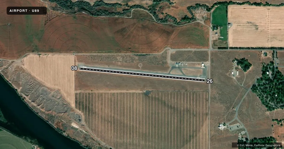
Airport sketch
Runways drawn to scale from FAA survey coordinates, rendered over satellite imagery. Not for navigation.
Approaches & charts
Services on the field
Fuel grades, oxygen, maintenance, ramp storage and lighting — as declared to the FAA by the airport operator.
Fuel & services
- Fuel
- Not available
- Oxygen (bottled)
- Not available
- Oxygen (bulk)
- Not available
- Airframe repair
- Not available
- Power plant repair
- Not available
- Other services
- AGRI
Ramp & ground
- Transient storage
- Tie-down
- Landing fee
- No fee published
- Customs
- Not available
- Lighting schedule
- SEE RMK
- Beacon schedule
- SEE RMK
- Beacon
- White / Green (civil land)(WG)
- Wind indicator
- Yes
- Segmented circle
- Yes
Fuel & FBOs
Cheapest 100LL and Jet A on the field and nearby. Always confirm with the FBO before taxi.
Airport notes
Surface conditions, obstructions, local procedures, lighting outages and other notes published with each FAA cycle.
General notes
- RWY 08 +150' PLINE CROSSES SNAKE RIVER CANYON APPROX 5 MILES DOWNRIVER.
- RY 08/26 DISTANCE TO GO MARKERS EVERY 1000 FT S SIDE OF RY.
- FOR CD CTC MUO RAPCON AT 208-828-6096 WHEN OPN. SALT LAKE ARTCC AT 801-320-2568 WHEN CLSD.
Lighting notes
- ACTIVATE BEACON-CTAF,
- ACTVT MIRL RY 08/26 - CTAF.
Approach & departure obstructions
- 08+4' FENCE AT 95' ON CNTRLN.
- 26+4 FT FENCE AT 75 FT ON CNTRLN; 15 FT ROAD AT 85 FT ON CNTRLN.
Other notes
- BUILT PRIOR TO 1959.
- NON-STD PAINTED TIRES.
VFR map & nearby airports
VFR sectional. Tap any ICAO chip to open that airport.
Key facts · U89
Answer card- ICAO
- U89
- Name
- GLENNS FERRY MUNI
- Location
- GLENNS FERRY, IDAHO
- Elevation
- 2,536 ft MSL
- Traffic pattern altitude
- 3,536 ft MSL (1,000 AGL)
- Control tower
- Non-towered (use CTAF)
- Total runways
- 1
- Longest runway
- 08/26 · 3,050 ft
- Published ILS approaches
- 0
- Published frequencies
- 1
- Magnetic variation
- 17°
- Current flight rules
- IFR
- Current wind
- 240° at 4 kt
- Favored runway now
- RWY 26
Glenns Ferry Muni sits in Glenns Ferry, Idaho. Field elevation is 2,536 ft MSL. The airport has one runway. Runway 08/26 is 3,050 ft asphalt, which is the longest runway on the field. There is no control tower. CTAF is 122.9.
No ILS approaches are published here. Pattern altitude is not published in the facts, so use the current Chart Supplement before you fly. The published remarks matter here. Medium intensity runway lights on 08/26 are activated by CTAF. The beacon is also activated by CTAF. Distance-to-go markers are on the south side of the runway every 1,000 ft. There is a 4-foot fence near the centerline off runway 08. Runway 26 also has a 4-foot fence near the centerline. A 15-foot road is near the centerline off runway 26. Runway 08 has a power line crossing Snake River Canyon about 5 miles downriver.
There are no on-field FBOs listed in the facts. Contact the airport operator directly before arrival, or call the field on CTAF for current FBO availability. Clearance delivery is handled through MUO RAPCON when open. When closed, contact Salt Lake ARTCC. This is a non-towered field with terrain and obstacle awareness that matters on both ends of the runway.