METAR & TAF 08U
08U does not publish a METAR.
Showing the nearest reporting station: KEKO (ELKO RGNL) · 41.6 NM away. Conditions at 08U may differ.
METAR · KEKO
Observed 08:56Z
KEKO 260856Z AUTO 00000KT 10SM CLR 18/06 A3009 RMK AO2 SLP122 T01830061 51005
- Wind
- 000° @ 0 kt
- Visibility
- 10 SM
- Temp / Dew
- 18°C / 6°C
- Altimeter
- 30.09 inHg
- Clouds
- CLR
- Density alt
- 8,081 ft
- Ceiling
- Unlimited
- Rules
- VFR
Airport info & contacts
Manager on record, flight service, ARTCC, attendance schedule and pattern altitude — published by the FAA and refreshed every 28 days.
Location
- From city
- 3 NM NW
- VFR sectional
- SALT LAKE CITY
- ARTCC
- ZLC · SALT LAKE CITY
- NOTAM facility
- RNO (NOTAM-D)
Airport manager
- Name
- EDDIE KING
- Phone
- 775-758-6409
- Address
- HC 31 BOX 142, HC 31 BOX 142, ELKO NV 89801
Flight service · Hours
- FSS RNO
- RENO1-800-WX-BRIEF
- Attendance
- Unattended
Frequencies
Tap any row to copy the frequency to your clipboard.
Runways & pattern
Full pagePattern entry · RWY 01
LEFT TRAFFICRunway end performance
| End | TORA | TODA | ASDA | LDA | VGSI | Approach lights | Obstruction |
|---|---|---|---|---|---|---|---|
| 19 | — | — | — | — | — | — | 4', fence, 50' from thr, 0' R of cntrln, slope 12 |
Declared distances in feet. TORA = takeoff run available, TODA = takeoff distance, ASDA = accelerate-stop, LDA = landing distance.
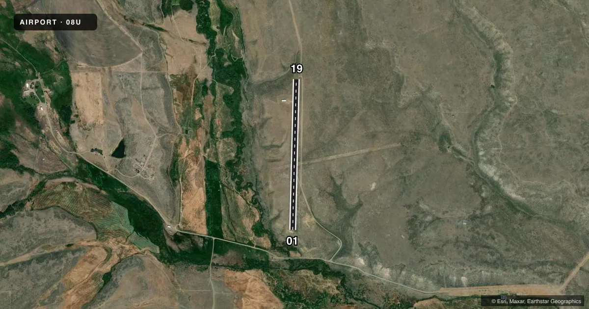
Airport sketch
Runways drawn to scale from FAA survey coordinates, rendered over satellite imagery. Not for navigation.
Approaches & charts
Services on the field
Fuel grades, oxygen, maintenance, ramp storage and lighting — as declared to the FAA by the airport operator.
Fuel & services
- Fuel
- Not available
- Oxygen (bottled)
- Not available
- Oxygen (bulk)
- Not available
- Airframe repair
- Not available
- Power plant repair
- Not available
Ramp & ground
- Transient storage
- Tie-down
- Landing fee
- No fee published
- Wind indicator
- No
- Segmented circle
- No
Fuel & FBOs
Cheapest 100LL and Jet A on the field and nearby. Always confirm with the FBO before taxi.
Airport notes
Surface conditions, obstructions, local procedures, lighting outages and other notes published with each FAA cycle.
General notes
- RWY 01 TRRN DROPS OFF 150 FT END OF RWY.
- FOR CD CTC SALT LAKE ARTCC AT 801-320-2568.
Other notes
- ESTAB PRIOR TO 15 MAY 1959
- ARPT LEASED AND OPRD BY PX ELLISON RANCHING CO.
- 01/19FIRST 800 FT OF RWY 01 ROUGH, UNEVEN & RUTTED.
VFR map & nearby airports
VFR sectional. Tap any ICAO chip to open that airport.
Key facts · 08U
Answer card- ICAO
- 08U
- Name
- STEVENS-CROSBY
- Location
- NORTH FORK, NEVADA
- Elevation
- 6,397 ft MSL
- Traffic pattern altitude
- 7,397 ft MSL (1,000 AGL)
- Control tower
- Non-towered (use CTAF)
- Total runways
- 1
- Longest runway
- 01/19 · 3,600 ft
- Published ILS approaches
- 0
- Published frequencies
- 1
- Magnetic variation
- 16°
- Current flight rules
- VFR
- Current wind
- 000° at 0 kt
- Favored runway now
- –
Stevens-Crosby (08U) sits near North Fork, Nevada. The field elevation is 6,397 ft MSL. It has one runway. Runway 01/19 is 3,600 ft long and surfaced with dirt. The airport is not towered. CTAF is 122.9.
No ILS approaches are published here. The pattern altitude is not published, so use standard 1,000 ft AGL for light piston operations unless the current Chart Supplement says otherwise. The airport is leased and operated by PX Ellison Ranching Company. Clearance delivery is handled through Salt Lake ARTCC at 801-320-2568.
A first-time pilot should pay close attention to the field conditions. The first 800 ft of runway 01 is rough, uneven and rutted. Terrain drops off 150 ft beyond the end of runway 01. That makes the departure end worth a careful look before takeoff. This is a high-elevation strip too, so performance planning matters. No on-field FBOs are listed. Check with the airport operator or the FBO directly by phone before arrival if you need current services.