METAR & TAF KBAM
Current METAR
Observed 13:15Z
KBAM 271315Z AUTO 25003KT 10SM CLR 15/M05 A3012 RMK AO1
- Wind
- 250° @ 3 kt
- Visibility
- 10 SM
- Temp / Dew
- 15°C / -5°C
- Altimeter
- 30.12 inHg
- Clouds
- CLR
- Density alt
- 5,377 ft
- Ceiling
- Unlimited
- Rules
- VFR
Airport info & contacts
Manager on record, flight service, ARTCC, attendance schedule and pattern altitude — published by the FAA and refreshed every 28 days.
Location
- From city
- 3 NM SE
- VFR sectional
- SALT LAKE CITY
- ARTCC
- ZLC · SALT LAKE CITY
- NOTAM facility
- RNO (NOTAM-D)
Airport manager
- Name
- BERT RAMOS
- Phone
- 775-455-6860
- Address
- 50 STATE ROUTE 305, BATTLE MOUNTAIN NV 89820
Flight service · Hours
- FSS RNO
- RENO1-800-WX-BRIEF
- Attendance
- OCT-MAY · 0700-1700
- JUN-SEP · 0700-1800
Frequencies
Tap any row to copy the frequency to your clipboard.
Runways & pattern
Full pagePattern entry · RWY 22
LEFT TRAFFIC| Runway | Heading (°M) | Length | Surface | Traffic |
|---|---|---|---|---|
| 04/22Favored | 36° / 216° | 7,300 ft | ASPH | Standard L |
| 13/31 | 126° / 306° | 7,299 ft | ASPH | Standard L |
Runway end performance
| End | TORA | TODA | ASDA | LDA | VGSI | Approach lights | Obstruction |
|---|---|---|---|---|---|---|---|
| 04 | — | — | — | — | PAPI 4-box right(3.2°) | — | — |
| 22 | — | — | — | — | PAPI 4-box left(3°) | — | — |
Declared distances in feet. TORA = takeoff run available, TODA = takeoff distance, ASDA = accelerate-stop, LDA = landing distance.
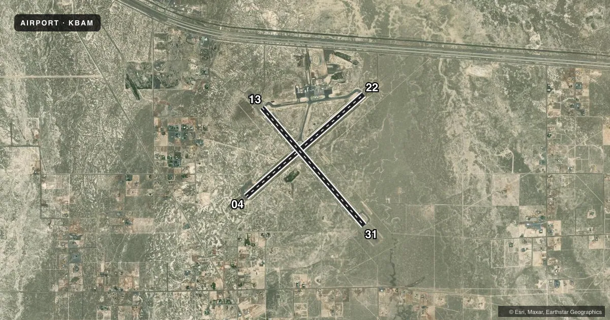
Airport sketch
Runways drawn to scale from FAA survey coordinates, rendered over satellite imagery. Not for navigation.
Approaches & charts
Services on the field
Fuel grades, oxygen, maintenance, ramp storage and lighting — as declared to the FAA by the airport operator.
Fuel & services
- Fuel
- 100LLA
- Oxygen (bottled)
- Not available
- Oxygen (bulk)
- Not available
- Airframe repair
- Major
- Power plant repair
- Major
- Other services
- AFRT,AGRI,AMB,SURV
Ramp & ground
- Transient storage
- Tie-down
- Hangar
- Landing fee
- No fee published
- Customs
- Not available
- Lighting schedule
- SEE RMK
- Beacon schedule
- SS-SR
- Beacon
- White / Green (civil land)(WG)
- Wind indicator
- Lighted
- Segmented circle
- Yes
Fuel & FBOs
Cheapest 100LL and Jet A on the field and nearby. Always confirm with the FBO before taxi.
Airport notes
Surface conditions, obstructions, local procedures, lighting outages and other notes published with each FAA cycle.
General notes
- (E81) EDGE REFLECTORS ON TWYS AND RAMP.
- FOR CD IF UNA TO CTC ON FSS FREQ, CTC SALT LAKE ARTCC AT 801-320-2568.
Lighting notes
- ACTVT REIL RWY 04 & 22; PAPI RWY 04 & 22; MIRL RWY 04/22 & 13/31; PERI LGTS H1 - CTAF.
Runway surface & condition
- 04/22PCR VALUE: 63/F/C/W/T
- 13/31PCR VALUE: 63/F/C/W/T
Approach & departure obstructions
- 04RWY NRS FADED.
- 13THR MARKINGS FADED.
- 22RWY NRS FADED.
- 31THR MARKINGS FADED.
- H1BLACK OUTLINE IS PARTIALLY VSB, W INTERIOR GONE.
- H2BLACK OUTLINE PARTIALLY VSB. W INTERIOR GONE.
Other notes
- 1AFT HRS CALL (775) 635-2245.
- 13/31PCI 54 L & T ALLIGATOR PATCHING, BONE CRACKING, WEEDS GROWING THRU CRACKS.
VFR map & nearby airports
VFR sectional. Tap any ICAO chip to open that airport.
Key facts · KBAM
Answer card- ICAO
- KBAM
- Name
- BATTLE MOUNTAIN
- Location
- BATTLE MOUNTAIN, NEVADA
- Elevation
- 4,536.1 ft MSL
- Traffic pattern altitude
- 5,536.1 ft MSL (1,000 AGL)
- Control tower
- Non-towered (use CTAF)
- Total runways
- 2
- Longest runway
- 04/22 · 7,300 ft
- Published ILS approaches
- 0
- Published frequencies
- 2
- Magnetic variation
- 13°
- Current flight rules
- VFR
- Current wind
- 250° at 3 kt
- Favored runway now
- RWY 22
Battle Mountain Airport (KBAM) sits in Battle Mountain, Nevada. Field elevation is 4,536.1 ft MSL. The airport has two asphalt runways. Runway 04/22 is 7,300 ft. Runway 13/31 is 7,299 ft, so 04/22 is the longest by a foot. There is no control tower. CTAF and UNICOM are both 122.8.
No ILS approaches are published here. Pattern altitude is not published, so use the standard 1,000 ft AGL for light piston traffic unless the current Chart Supplement says otherwise. That puts the usual pattern reference at about 5,536 ft MSL. The runway lighting setup is useful to know. Runway end identifier lights are active on 04 and 22. PAPI is installed on 04 and 22. Medium intensity runway lights are installed on both runways.
There are no on-field FBOs listed in the facts. FBO options vary. Contact the airport operator directly before arrival. You can also call the field on CTAF/UNICOM for current FBO availability. The published remarks also flag surface issues on 13/31. The pavement shows patching, cracking and weeds through cracks. Threshold markings on 13 and 31 are faded. Runway 04 and 22 numbers are also faded. This is a high-elevation field in open country, so expect density altitude to matter on warm days. Check the current Chart Supplement for any published local procedures before you go.