METAR & TAF U74
U74 does not publish a METAR.
Showing the nearest reporting station: KBAM (BATTLE MOUNTAIN) · 18.0 NM away. Conditions at U74 may differ.
METAR · KBAM
Observed 05:55Z
KBAM 270555Z AUTO 31012KT 10SM CLR 27/M08 A3007 RMK AO1
- Wind
- 310° @ 12 kt
- Visibility
- 10 SM
- Temp / Dew
- 27°C / -8°C
- Altimeter
- 30.07 inHg
- Clouds
- CLR
- Density alt
- 7,195 ft
- Ceiling
- Unlimited
- Rules
- VFR
Airport info & contacts
Manager on record, flight service, ARTCC, attendance schedule and pattern altitude — published by the FAA and refreshed every 28 days.
Location
- From city
- 1 NM E
- VFR sectional
- SALT LAKE CITY
- ARTCC
- ZLC · SALT LAKE CITY
- NOTAM facility
- RNO (NOTAM-D)
Airport manager
- Name
- JEB ROWLEY
- Phone
- (775) 237-5372
- Address
- 701 S MAIN STREET, PO BOX 714, EUREKA NV 89316
Flight service · Hours
- FSS RNO
- RENO1-800-WX-BRIEF
- Attendance
- Unattended
Frequencies
Tap any row to copy the frequency to your clipboard.
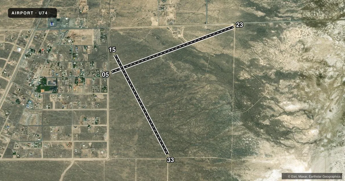
Runways & pattern
Full pagePattern entry · RWY 33
LEFT TRAFFIC| Runway | Heading (°M) | Length | Surface | Traffic |
|---|---|---|---|---|
| 05/23 | 54° / 234° | 5,424 ft | DIRT | Standard L |
| 15/33Favored | 136° / 316° | 4,650 ft | DIRT | Standard L |
Runway end performance
| End | TORA | TODA | ASDA | LDA | VGSI | Approach lights | Obstruction |
|---|---|---|---|---|---|---|---|
| 05 | — | — | — | — | — | — | 17', road, 35' from thr, 0' R of cntrln, slope 2 |
| 23 | — | — | — | — | — | — | 15', road, 30' from thr, 0' R of cntrln, slope 2 |
| 15 | — | — | — | — | — | — | 60', tree, 675' from thr, 100' R of cntrln, slope 11 |
Declared distances in feet. TORA = takeoff run available, TODA = takeoff distance, ASDA = accelerate-stop, LDA = landing distance.
Airport sketch
Runways drawn to scale from FAA survey coordinates, rendered over satellite imagery. Not for navigation.
Approaches & charts
Services on the field
Fuel grades, oxygen, maintenance, ramp storage and lighting — as declared to the FAA by the airport operator.
Fuel & services
- Fuel
- Not available
- Other services
- AGRI
Ramp & ground
- Transient storage
- Tie-down
- Landing fee
- No fee published
- Customs
- Not available
- Wind indicator
- Yes
- Segmented circle
- No
Fuel & FBOs
Cheapest 100LL and Jet A on the field and nearby. Always confirm with the FBO before taxi.
Airport notes
Surface conditions, obstructions, local procedures, lighting outages and other notes published with each FAA cycle.
General notes
- UNCONTROLLED VEHICLE ACES ALL RWYS.
- CATTLE ON & INVOF RWYS.
- RWY 15/33 - 2 FT EARTH RIDGES ALG RWY EDGES AND 3 FT BERM ALG BOTH SIDES 0F RWY.
- RWY 05/23 - 1 FT DRAINAGE DITCH BOTH SIDES OF RWY AND 2 FT EARTH RIDGES ALG RWY EDGES.
- RWY 05/23 - FIRST 1600 FT OF RWY ROUGH SFC.
- FOR CD CTC SALT LAKE ARTCC AT 801-320-2568.
Other notes
- 2 TIE DOWN POINTS NW CORNER OF ARPT.
- 05/23EAST 3000 FEET OF RWY 23 SOFT WITH LATERAL RIVULET/DITCHES 6-10 INCHES DEEP.
- 15/33WEEDS CVR OVER 1/2 THE RWY SFC.
VFR map & nearby airports
VFR sectional. Tap any ICAO chip to open that airport.
Key facts · U74
Answer card- ICAO
- U74
- Name
- CRESCENT VALLEY
- Location
- CRESCENT VALLEY, NEVADA
- Elevation
- 4,790.8 ft MSL
- Traffic pattern altitude
- 5,790.8 ft MSL (1,000 AGL)
- Control tower
- Non-towered (use CTAF)
- Total runways
- 2
- Longest runway
- 05/23 · 5,424 ft
- Published ILS approaches
- 0
- Published frequencies
- 1
- Magnetic variation
- 16°
- Current flight rules
- VFR
- Current wind
- 310° at 12 kt
- Favored runway now
- RWY 33
Crescent Valley Airport (U74) sits in Crescent Valley, Nevada. Field elevation is 4,790.8 ft MSL. It has two dirt runways. The longest is 5,424 ft on runway 05/23. There is no control tower. CTAF is 122.9.
No ILS approaches are published here. Pattern altitude is not published, so use the standard 1,000 ft AGL for light piston traffic unless the current Chart Supplement says otherwise. That puts the pattern at about 5,790.8 ft MSL based on the listed field elevation.
This is a rough field. The published remarks call out soft ground on the east 3,000 ft of runway 23, rough surface on the first 1,600 ft of runway 05/23 and cattle on or near the runways. Runway 14/32 has earth ridges and berms along the edges. Weeds cover over half of runway 14/32. Uncontrolled vehicle access is allowed on all runways. So a careful taxi and landing scan matters here. There are no on-field FBOs listed. For clearance delivery, contact Salt Lake ARTCC at 801-320-2568.