METAR & TAF KTMT
Current METAR
Observed 18:55Z
KTMT 261855Z AUTO 21005KT 10SM CLR 30/02 A3021 RMK AO2 T03030021
- Wind
- 210° @ 5 kt
- Visibility
- 10 SM
- Temp / Dew
- 30°C / 2°C
- Altimeter
- 30.21 inHg
- Clouds
- CLR
- Density alt
- 8,552 ft
- Ceiling
- Unlimited
- Rules
- VFR
Airport info & contacts
Manager on record, flight service, ARTCC, attendance schedule and pattern altitude — published by the FAA and refreshed every 28 days.
Location
- From city
- 4 NM SW
- VFR sectional
- LAS VEGAS
- ARTCC
- ZLC · SALT LAKE CITY
- NOTAM facility
- RNO (NOTAM-D)
Airport manager
- Name
- BERT RAMOS
- Phone
- 775-455-6860
- Address
- 50 STATE ROUTE 305, BATTLE MOUNTAIN NV 89820
Flight service · Hours
- FSS RNO
- RENO1-800-WX-BRIEF
- Attendance
- Unattended
Frequencies
Tap any row to copy the frequency to your clipboard.
Runways & pattern
Full pagePattern entry · RWY 19
LEFT TRAFFICRunway end performance
| End | TORA | TODA | ASDA | LDA | VGSI | Approach lights | Obstruction |
|---|---|---|---|---|---|---|---|
| 01 | — | — | — | — | — | — | 4', fence, 320' from thr, 0' R of cntrln, slope 30 |
Declared distances in feet. TORA = takeoff run available, TODA = takeoff distance, ASDA = accelerate-stop, LDA = landing distance.
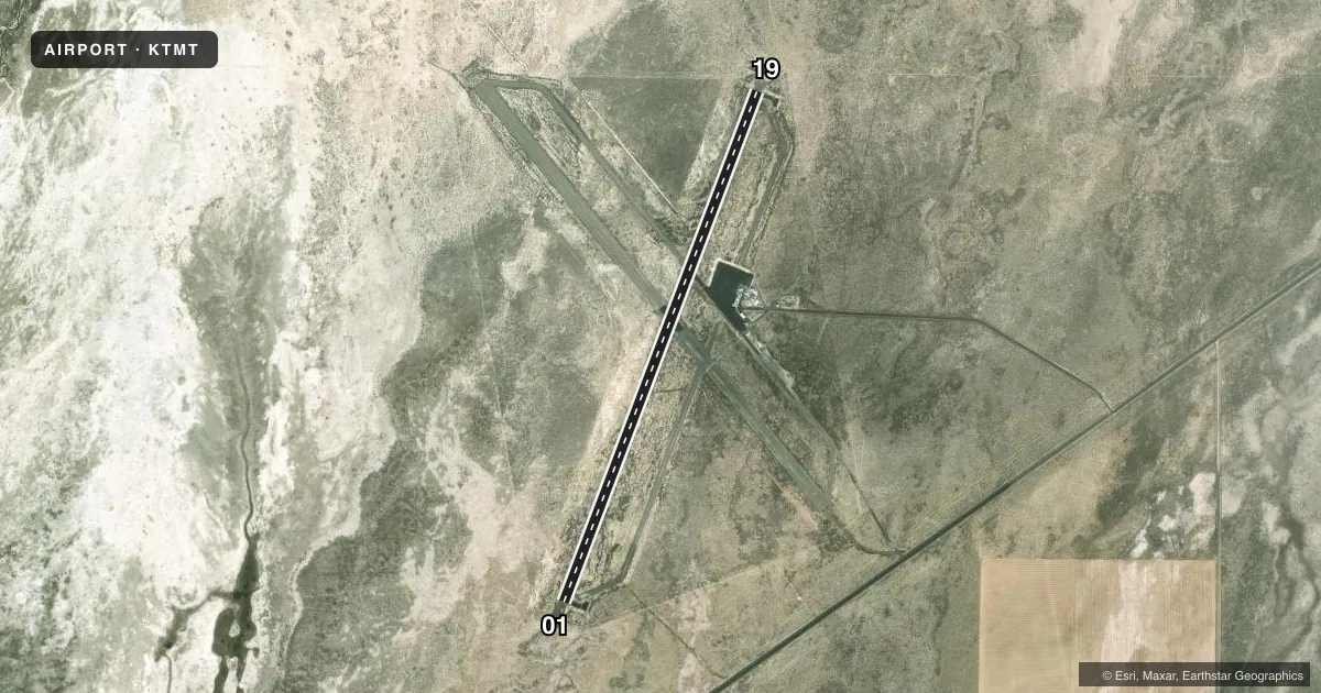
Airport sketch
Runways drawn to scale from FAA survey coordinates, rendered over satellite imagery. Not for navigation.
Approaches & charts
Services on the field
Fuel grades, oxygen, maintenance, ramp storage and lighting — as declared to the FAA by the airport operator.
Fuel & services
- Fuel
- 100LLA
- Oxygen (bottled)
- Not available
- Oxygen (bulk)
- Not available
- Airframe repair
- Not available
- Power plant repair
- Not available
- Other services
- AFRT,AMB
Ramp & ground
- Transient storage
- Tie-down
- Landing fee
- No fee published
- Customs
- Not available
- Lighting schedule
- SS-SR
- Beacon schedule
- SS-SR
- Beacon
- White / Green (civil land)(WG)
- Wind indicator
- Lighted
- Segmented circle
- Yes
Fuel & FBOs
Cheapest 100LL and Jet A on the field and nearby. Always confirm with the FBO before taxi.
Airport notes
Surface conditions, obstructions, local procedures, lighting outages and other notes published with each FAA cycle.
General notes
- COURTESY CAR AVBL, INQUIRE IN TRML BLDG.
- FOR CD CTC SALT LAKE ARTCC AT 801-320-2568.
- 100LL AND JET A FUEL AVBL SELF SVC ONLY.
Fuel notes
- 100LLFUEL IS SELF SVC.
Runway surface & condition
- 01/19PCR VALUE: 20/F/C/X/T
Other notes
- MILITARY ACFT OPER IN VICINITY OF ARPT.
VFR map & nearby airports
VFR sectional. Tap any ICAO chip to open that airport.
Key facts · KTMT
Answer card- ICAO
- KTMT
- Name
- AUSTIN
- Location
- AUSTIN, NEVADA
- Elevation
- 5,735.1 ft MSL
- Traffic pattern altitude
- 6,735.1 ft MSL (1,000 AGL)
- Control tower
- Non-towered (use CTAF)
- Total runways
- 1
- Longest runway
- 01/19 · 5,999 ft
- Published ILS approaches
- 0
- Published frequencies
- 1
- Magnetic variation
- 12°
- Current flight rules
- VFR
- Current wind
- 210° at 5 kt
- Favored runway now
- RWY 19
Austin Airport is in Austin, Nevada. Field elevation is 5,735.1 ft MSL. The airport has one runway. Runway 01/19 is 5,999 ft long and paved with asphalt. There is no control tower. CTAF is 122.9.
No ILS approaches are published here. Pattern altitude is not published, so use 1,000 ft AGL for light piston operations unless the current FAA Chart Supplement says otherwise. The airport remarks say 100LL and Jet A are available self-serve only. A courtesy car is available. Ask in the terminal building. Military aircraft operate in the vicinity of the airport. Clearance delivery is handled through Salt Lake ARTCC at 801-320-2568.
This is a high-elevation field in central Nevada, so performance planning matters. Expect density altitude to be a factor, especially on warm days. The runway is long enough for a lot of general aviation traffic, but the pavement strength is published as 20/F/C/X/T, so verify your aircraft weight and pavement needs before you go. If you need current noise, airspace, or operating details, check the current FAA Chart Supplement before departure.