METAR & TAF 05U
Current METAR
Observed 15:35Z
K05U 261535Z AUTO 00000KT 10SM CLR 23/12 A3024 RMK A01
- Wind
- 000° @ 0 kt
- Visibility
- 10 SM
- Temp / Dew
- 23°C / 12°C
- Altimeter
- 30.24 inHg
- Clouds
- CLR
- Density alt
- 7,951 ft
- Ceiling
- Unlimited
- Rules
- VFR
Airport info & contacts
Manager on record, flight service, ARTCC, attendance schedule and pattern altitude — published by the FAA and refreshed every 28 days.
Location
- From city
- 6 NM NW
- VFR sectional
- LAS VEGAS
- ARTCC
- ZLC · SALT LAKE CITY
- NOTAM facility
- RNO (NOTAM-D)
Airport manager
- Name
- JEB ROWLEY
- Phone
- 775-237-5372
- Address
- 701 S MAIN STREET, PO BOX 714, EUREKA NV 89316
Flight service · Hours
- FSS RNO
- RENO1-800-WX-BRIEF
- Attendance
- 0800-1700
Frequencies
Tap any row to copy the frequency to your clipboard.
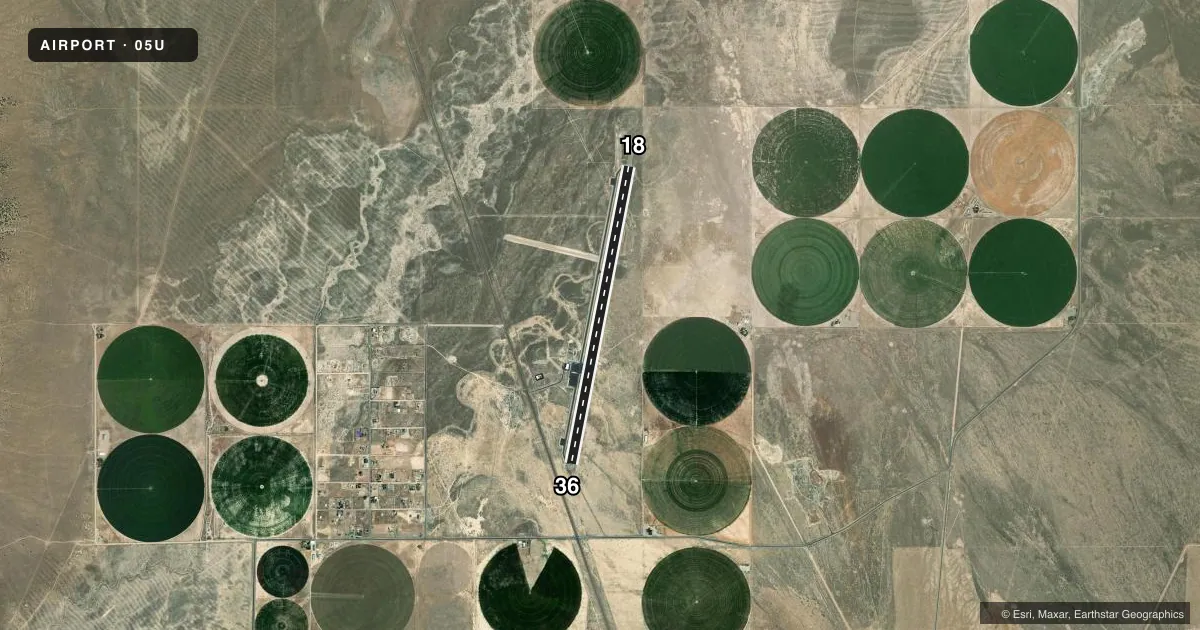
Runways & pattern
Full pagePattern entry · RWY 18
LEFT TRAFFICRunway end performance
| End | TORA | TODA | ASDA | LDA | VGSI | Approach lights | Obstruction |
|---|---|---|---|---|---|---|---|
| 18 | — | — | — | — | PAPI 2-box left(3°) | — | — |
| 36 | — | — | — | — | PAPI 2-box left(3°) | — | 35', pline, 800' from thr, 0' R of cntrln, slope 17 |
Declared distances in feet. TORA = takeoff run available, TODA = takeoff distance, ASDA = accelerate-stop, LDA = landing distance.
Airport sketch
Runways drawn to scale from FAA survey coordinates, rendered over satellite imagery. Not for navigation.
Approaches & charts
Services on the field
Fuel grades, oxygen, maintenance, ramp storage and lighting — as declared to the FAA by the airport operator.
Fuel & services
- Fuel
- 100LLAA+
- Other services
- AGRI,AMB
Ramp & ground
- Transient storage
- Tie-down
- Hangar
- Landing fee
- No fee published
- Customs
- Not available
- Lighting schedule
- SEE RMK
- Beacon schedule
- SS-SR
- Beacon
- White / Green (civil land)(WG)
- Wind indicator
- Lighted
- Segmented circle
- Yes
Fuel & FBOs
Cheapest 100LL and Jet A on the field and nearby. Always confirm with the FBO before taxi.
Airport notes
Surface conditions, obstructions, local procedures, lighting outages and other notes published with each FAA cycle.
General notes
- FOR CD IF UNA TO CTC ON FSS FREQ, CTC SALT LAKE ARTCC AT 801-320-2568.
- COLD TEMPERATURE AIRPORT. ALTITUDE CORRECTION REQUIRED AT OR BELOW -17C.
Lighting notes
- ACTVT REIL RWY 18 & 36; PAPI RWY 18 & 36; HIRL RWY 18/36 - CTAF. DUSK-DAWN; REIL RWY 18 & 36; PAPI RWY 18 & 36; HIRL RWY 18/36 PRESET LOW INTST; INCR INTST - CTAF.
Approach & departure obstructions
- 18UNLGTD PLINES & POLES PENETRATE 20 - 1 APCH SFC.
- 18UNLGTD PLINES & POLES.
Other notes
- PAY PHONE AVAILABLE.
- 1AFT HR - 775-237-5330.
- OWNERCOUNTY OF EUREKA
VFR map & nearby airports
VFR sectional. Tap any ICAO chip to open that airport.
Key facts · 05U
Answer card- ICAO
- 05U
- Name
- EUREKA
- Location
- EUREKA, NEVADA
- Elevation
- 5,957.8 ft MSL
- Traffic pattern altitude
- 6,957.8 ft MSL (1,000 AGL)
- Control tower
- Non-towered (use CTAF)
- Total runways
- 1
- Longest runway
- 18/36 · 7,300 ft
- Published ILS approaches
- 0
- Published frequencies
- 1
- Magnetic variation
- 13°
- Current flight rules
- VFR
- Current wind
- 000° at 0 kt
- Favored runway now
- –
Eureka Airport sits in Eureka, Nevada at 5,957.8 ft MSL. It has one runway, 18/36, which is 7,300 ft of asphalt. There is no control tower. CTAF is 122.9. No ILS approaches are published here.
The pattern altitude is not published. Use the standard 1,000 ft AGL pattern for light piston traffic unless local procedures or current published data say otherwise. The field is in high country, so performance planning matters. This is also a cold temperature airport. Altitude correction is required at or below minus 17 degrees Celsius.
Eureka Airport is on the field. It carries 100LL and Jet A. Call (775) 237-6100 for current service details before you go. The airport has REILs, PAPI and high intensity runway lights on 18/36. The lights are controlled by CTAF from dusk to dawn. Increased intensity is available by radio call. Watch for unlighted power lines and poles near runway 18. They also penetrate the 20 to 1 approach surface for that runway.
If you need clearance delivery help and cannot reach Flight Service, the remarks direct pilots to Salt Lake ARTCC at 801-320-2568. The owner is County of Eureka. A pay phone is available on the field.