METAR & TAF 01U
01U does not publish a METAR.
Showing the nearest reporting station: KELY (ELY/YELLAND FLD) · 45.6 NM away. Conditions at 01U may differ.
METAR · KELY
Observed 02:53Z
KELY 270253Z AUTO 17009KT 6SM HZ CLR 27/01 A3016 RMK AO2 SLP090 T02720006 53001
- Wind
- 170° @ 9 kt
- Visibility
- 6 SM
- Temp / Dew
- 27°C / 1°C
- Altimeter
- 30.16 inHg
- Clouds
- CLR
- Density alt
- 7,507 ft
- Ceiling
- Unlimited
- Rules
- VFR
Airport info & contacts
Manager on record, flight service, ARTCC, attendance schedule and pattern altitude — published by the FAA and refreshed every 28 days.
Location
- From city
- 6 NM SE
- VFR sectional
- LAS VEGAS
- ARTCC
- ZLC · SALT LAKE CITY
- NOTAM facility
- RNO (NOTAM-D)
Airport manager
- Name
- UNKNOWN
Flight service · Hours
- FSS RNO
- RENO1-800-WX-BRIEF
- Attendance
- Unattended
Frequencies
Tap any row to copy the frequency to your clipboard.
Runways & pattern
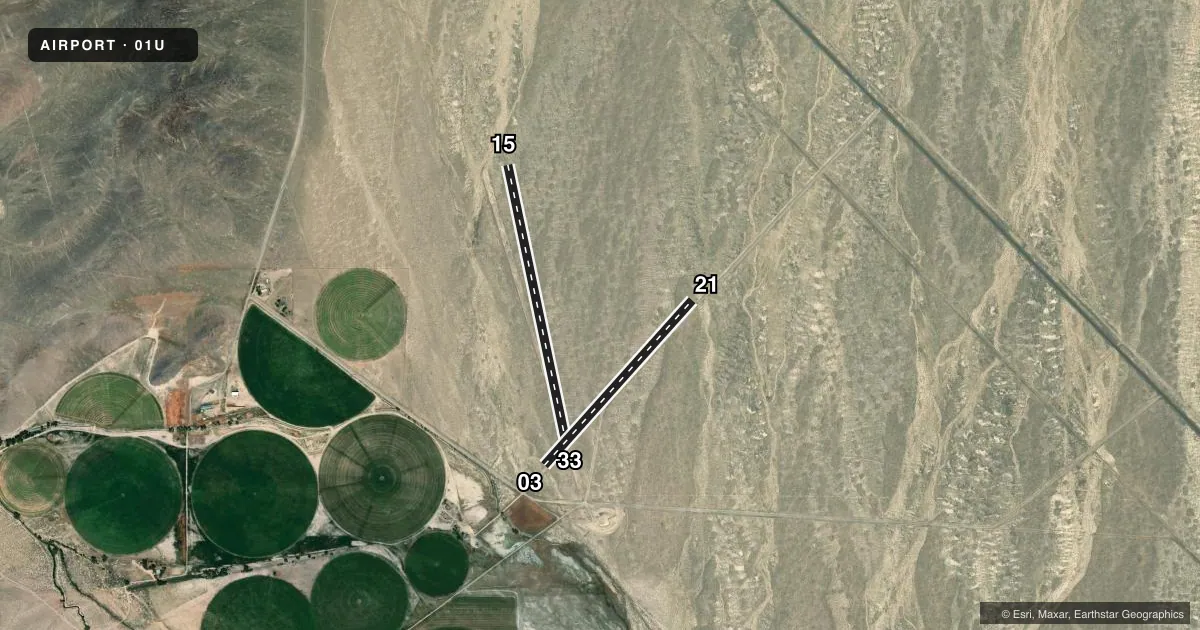
Full pagePattern entry · RWY 15
LEFT TRAFFIC| Runway | Heading (°M) | Length | Surface | Traffic |
|---|---|---|---|---|
| 15/33Favored | 153° / 333° | 3,400 ft | DIRT | Standard L |
| 03/21 | 27° / 207° | 2,700 ft | DIRT | Standard L |
Runway end performance
| End | TORA | TODA | ASDA | LDA | VGSI | Approach lights | Obstruction |
|---|---|---|---|---|---|---|---|
| 15 | — | — | — | — | — | — | 15', road, 30' from thr, 0' R of cntrln, slope 2 |
| 03 | — | — | — | — | — | — | 15', road, 0' from thr, 47' R of cntrln, slope 0 |
| 21 | — | — | — | — | — | — | 15', road, 0' from thr, 47' R of cntrln, slope 0 |
Declared distances in feet. TORA = takeoff run available, TODA = takeoff distance, ASDA = accelerate-stop, LDA = landing distance.
Airport sketch
Runways drawn to scale from FAA survey coordinates, rendered over satellite imagery. Not for navigation.
Approaches & charts
Services on the field
Fuel grades, oxygen, maintenance, ramp storage and lighting — as declared to the FAA by the airport operator.
Fuel & services
- Fuel
- Not available
- Oxygen (bottled)
- Not available
- Oxygen (bulk)
- Not available
- Airframe repair
- Not available
- Power plant repair
- Not available
Ramp & ground
- Transient storage
- Tie-down
- Landing fee
- No fee published
- Wind indicator
- No
- Segmented circle
- No
Fuel & FBOs
Cheapest 100LL and Jet A on the field and nearby. Always confirm with the FBO before taxi.
Airport notes
Surface conditions, obstructions, local procedures, lighting outages and other notes published with each FAA cycle.
General notes
- WATCH FOR LIVESTOCK ON RWYS.
- RYS 03/21 & 15/33 HAVE UNCONTROLLED VEH ACCESS.
- RY 03/21 +1 FT BERM FULL LENGTH NORTH SIDE, -2 FT DITCH FULL LENGTH SOUTH SIDE.
- RY 15/33 +1 FT BERM BOTH SIDES OF RY.
- RY 3, 2 STAKES N EDGE OF RY, 135 FT FROM RY END, +4 FT HIGH.
- FOR CD CTC SALT LAKE ARTCC AT 801-320-2568.
Approach & departure obstructions
- 03PLINE 400 FT FROM RY END, +20 FT, BOTH SIDES OF CNTRLN, MARKED W/ORANGE BALL, 20:1 SLOPE.
- 1511PLINE 1500 FT FROM RY END 35 FT, BOTH SIDES OF CNTRLN, MKD W/ ORANGE BALL, 42:1 SLOPE.
Other notes
- ESTABD PRIOR TO MAY 1959.
- TIE DOWNS PROVDD NEAR RWY INTXN.
VFR map & nearby airports
VFR sectional. Tap any ICAO chip to open that airport.
Key facts · 01U
Answer card- ICAO
- 01U
- Name
- DUCKWATER
- Location
- DUCKWATER, NEVADA
- Elevation
- 5,133 ft MSL
- Traffic pattern altitude
- 6,133 ft MSL (1,000 AGL)
- Control tower
- Non-towered (use CTAF)
- Total runways
- 2
- Longest runway
- 15/33 · 3,400 ft
- Published ILS approaches
- 0
- Published frequencies
- 1
- Magnetic variation
- 15°
- Current flight rules
- VFR
- Current wind
- 170° at 9 kt
- Favored runway now
- RWY 15
Duckwater Airport sits in Duckwater, Nevada. The field elevation is 5,133 ft MSL. It has two dirt runways. The longest is 3,400 ft on runway 15/33. There is no control tower. CTAF is 122.9. No ILS approaches are published.
Pattern altitude is not published. Use a standard 1,000 ft AGL pattern for light piston operations unless the current FAA Chart Supplement says otherwise. That puts the normal pattern reference at 6,133 ft MSL based on the listed field elevation. Runway 15/33 has berms on both sides. Runway 03/21 has a berm on the north side. It also has a ditch on the south side. The remarks also call out power lines near both runway ends. Watch for livestock on the runways. There are tie-downs near the runway intersection.
This is a high-elevation dirt strip with no tower and no published instrument approach. Plan for visual work only. Density altitude can be a factor here because of the elevation. Check winds, runway condition and obstacle clearance before you commit. For clearance delivery, contact Salt Lake ARTCC at 801-320-2568. If you need current operational details, check the current FAA Chart Supplement or call the airport operator directly.