METAR & TAF L92
L92 does not publish a METAR.
Showing the nearest reporting station: KVGT (NORTH LAS VEGAS) · 69.2 NM away. Conditions at L92 may differ.
METAR · KVGT
Observed 19:53Z
KVGT 261953Z 16006G17KT 10SM CLR 42/06 A2990 RMK AO2 SLP105 T04170056
- Wind
- 160° @ 6G17 kt
- Visibility
- 10 SM
- Temp / Dew
- 42°C / 6°C
- Altimeter
- 29.90 inHg
- Clouds
- CLR
- Density alt
- 7,924 ft
- Ceiling
- Unlimited
- Rules
- VFR
Airport info & contacts
Manager on record, flight service, ARTCC, attendance schedule and pattern altitude — published by the FAA and refreshed every 28 days.
Location
- From city
- 2 NM W
- VFR sectional
- LAS VEGAS
- ARTCC
- ZLA · LOS ANGELES
- NOTAM facility
- RNO (NOTAM-D)
Airport manager
- Name
- WENDY RUDDER
- Phone
- (702) 449-2418
- Address
- P.O. BOX 509, ALAMO NV 89001
Flight service · Hours
- FSS RNO
- RENO1-800-WX-BRIEF
- Attendance
- Unattended
Frequencies
Tap any row to copy the frequency to your clipboard.
Runways & pattern
Full pagePattern entry · RWY 14
LEFT TRAFFICRunway end performance
| End | TORA | TODA | ASDA | LDA | VGSI | Approach lights | Obstruction |
|---|---|---|---|---|---|---|---|
| 14 | — | — | — | — | PAPI 2-box left(3.25°) | — | — |
| 32 | — | — | — | — | PAPI 2-box left(2.75°) | — | — |
Declared distances in feet. TORA = takeoff run available, TODA = takeoff distance, ASDA = accelerate-stop, LDA = landing distance.
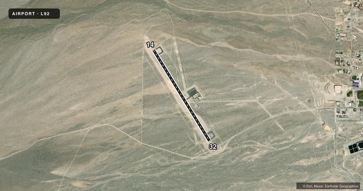
Airport sketch
Runways drawn to scale from FAA survey coordinates, rendered over satellite imagery. Not for navigation.
Approaches & charts
Services on the field
Fuel grades, oxygen, maintenance, ramp storage and lighting — as declared to the FAA by the airport operator.
Fuel & services
- Fuel
- Not available
Ramp & ground
- Transient storage
- Buoy
- Landing fee
- No fee published
- Lighting schedule
- SEE RMK
- Beacon schedule
- SS-SR
- Beacon
- White / Green (civil land)(WG)
- Wind indicator
- Yes
- Segmented circle
- Yes
Fuel & FBOs
Cheapest 100LL and Jet A on the field and nearby. Always confirm with the FBO before taxi.
Airport notes
Surface conditions, obstructions, local procedures, lighting outages and other notes published with each FAA cycle.
General notes
- FOR CD CTC NELLIS APP AT 702-652-4172.
Lighting notes
- ACTVT REIL RWY 14 & 32; PAPI RWY 14 & 32; HIRL RWY 14/32; TWY LGTS - CTAF.
Approach & departure obstructions
- 14UNUSBL BYD 4 NM.
Other notes
- E111: VFR USE.
- OWNERLEASED TO LINCOLN COUNTY FROM US BUREAU OF LAND MANAGEMENT
VFR map & nearby airports
VFR sectional. Tap any ICAO chip to open that airport.
Key facts · L92
Answer card- ICAO
- L92
- Name
- ALAMO LANDING FLD
- Location
- ALAMO, NEVADA
- Elevation
- 3,757.2 ft MSL
- Traffic pattern altitude
- 4,757.2 ft MSL (1,000 AGL)
- Control tower
- Non-towered (use CTAF)
- Total runways
- 1
- Longest runway
- 14/32 · 4,362 ft
- Published ILS approaches
- 0
- Published frequencies
- 1
- Magnetic variation
- 14°
- Current flight rules
- VFR
- Current wind
- 160° at 6 kt
- Favored runway now
- RWY 14
Alamo Landing Fld (L92) sits in Alamo, Nevada. The field elevation is 3,757.2 ft MSL. It has one runway, 14/32, which is 4,362 ft long and paved with asphalt. There is no control tower. CTAF is 122.9. No ILS approaches are published here. Plan for VFR use and check the current FAA Chart Supplement before you go if you need instrument details.
The published pattern altitude is not listed. For light piston operations, use the standard 1,000 ft AGL unless the current Chart Supplement says otherwise. That puts the pattern at about 4,757.2 ft MSL based on the field elevation. Runway 14 and 32 have runway end identifier lights, PAPI and high intensity runway lights. Taxiway lights are controlled on CTAF. Make sure you are set up to work the pattern and lighting from the radio.
There are no on-field FBOs listed in the facts, so contact the airport operator directly or call the field on CTAF for current services before arrival. The airport is leased to Lincoln County from the US Bureau of Land Management. One operational note matters here. Runway 14 is unusable beyond 4 NM. For clearance delivery, contact Nellis Approach at 702-652-4172. The field is a VFR-use airport, so keep an eye on local conditions, density altitude and your performance numbers before you launch.