METAR & TAF U08
U08 does not publish a METAR.
Showing the nearest reporting station: KVGT (NORTH LAS VEGAS) · 42.2 NM away. Conditions at U08 may differ.
METAR · KVGT
Observed 11:53Z
KVGT 271153Z AUTO 19007KT 10SM CLR 34/08 A2986 RMK AO2 SLP094 T03390078 10367 20339 53003
- Wind
- 190° @ 7 kt
- Visibility
- 10 SM
- Temp / Dew
- 34°C / 8°C
- Altimeter
- 29.86 inHg
- Clouds
- CLR
- Density alt
- 4,048 ft
- Ceiling
- Unlimited
- Rules
- VFR
Airport info & contacts
Manager on record, flight service, ARTCC, attendance schedule and pattern altitude — published by the FAA and refreshed every 28 days.
Location
- From city
- 2 NM N
- VFR sectional
- LAS VEGAS
- Pattern altitude
- 800 ft AGL · 2,166 ft MSL
- ARTCC
- ZLA · LOS ANGELES
- NOTAM facility
- RNO (NOTAM-D)
Airport manager
- Name
- KARINA TARNOWSKA
- Phone
- 702-261-3805
- Address
- 2730 AIRPORT DRIVE STE. 101, NORTH LAS VEGAS NV 89032
Flight service · Hours
- FSS RNO
- RENO1-800-WX-BRIEF
- Attendance
- THUR-MON · DALGT
Frequencies
Tap any row to copy the frequency to your clipboard.
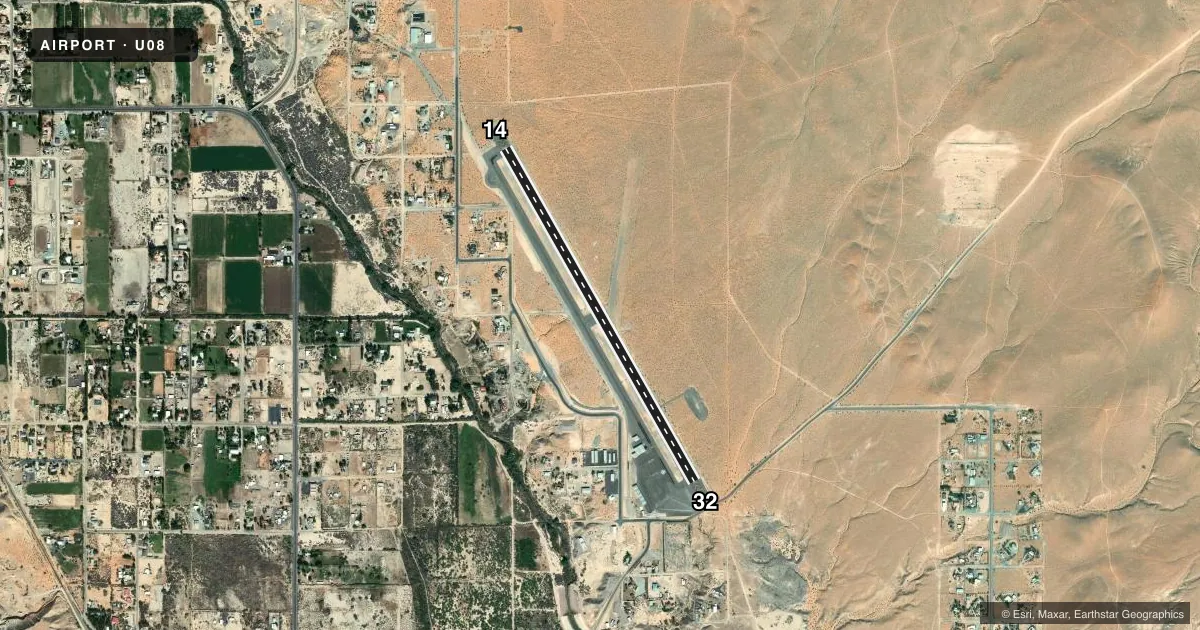
Runways & pattern
Full pagePattern entry · RWY 14
LEFT TRAFFICAirport sketch
Runways drawn to scale from FAA survey coordinates, rendered over satellite imagery. Not for navigation.
Approaches & charts
Services on the field
Fuel grades, oxygen, maintenance, ramp storage and lighting — as declared to the FAA by the airport operator.
Fuel & services
- Fuel
- 100LL
- Oxygen (bottled)
- Not available
- Oxygen (bulk)
- Not available
- Airframe repair
- Not available
- Power plant repair
- Not available
- Other services
- AMB,GLD,PAJA
Ramp & ground
- Transient storage
- Tie-down
- Landing fee
- No fee published
- Customs
- Not available
- Lighting schedule
- SEE RMK
- Beacon schedule
- SS-SR
- Beacon
- White / Green (civil land)(WG)
- Wind indicator
- Lighted
- Segmented circle
- Yes
Fuel & FBOs
Cheapest 100LL and Jet A on the field and nearby. Always confirm with the FBO before taxi.
Airport notes
Surface conditions, obstructions, local procedures, lighting outages and other notes published with each FAA cycle.
General notes
- ULTRALIGHT AND SKYDIVING ACTIVITY ONGOING ON OR NEAR THE ARPT.
- SKYDIVING ACT ON/INVOF ARPT DLY SR-SS.
- FOR CD CTC LOS ANGELES ARTCC AT 661-575-2079.
Lighting notes
- ACTVT MIRLS RY 14/32 - CTAF.
Other notes
- ESTABD PRIOR TO 15 MAY 1959.
- ONLY ENOUGH OIL FOR ENG NEED, NO EXTRA SALES AVAILABLE.
- 1TUE & WED SVC AVBL ON CALL (702) 397-8457.
VFR map & nearby airports
VFR sectional. Tap any ICAO chip to open that airport.
Key facts · U08
Answer card- ICAO
- U08
- Name
- PERKINS FLD
- Location
- OVERTON, NEVADA
- Elevation
- 1,365.9 ft MSL
- Traffic pattern altitude
- 2,165.9 ft MSL (800 AGL)
- Control tower
- Non-towered (use CTAF)
- Total runways
- 1
- Longest runway
- 14/32 · 4,811 ft
- Published ILS approaches
- 0
- Published frequencies
- 2
- Magnetic variation
- 14°
- Current flight rules
- VFR
- Current wind
- 190° at 7 kt
- Favored runway now
- RWY 14
Perkins Field is in Overton, Nevada. The field elevation is 1,365.9 ft MSL. It has one runway, 14/32, which is 4,811 ft long and asphalt. There is no control tower. CTAF and UNICOM are both 122.8. No ILS approaches are published.
Pattern altitude is 800 ft AGL, which is 2,165.9 ft MSL. That matters here because the field sits in a desert environment with a modest elevation. Expect density altitude to be a real factor on warm days. The published remarks also call out daily skydiving activity from sunrise to sunset. Ultralight activity is also ongoing on or near the airport. Plan your traffic scan carefully.
Perkins Field has one on-field FBO. Perkins Field carries AVGAS 100LL. The published remarks also note that Tuesday and Wednesday service is available on call at 702-397-8457. Activated medium intensity runway lighting for runway 14/32 is controlled by CTAF. For clearance delivery, contact Los Angeles ARTCC at 661-575-2079. If you are new to the field, brief the pattern. Watch for jump traffic. Verify current procedures with the airport operator or the FBO directly by phone before arrival.