METAR & TAF 1G4
1G4 does not publish a METAR.
Showing the nearest reporting station: KIGM (KINGMAN) · 44.0 NM away. Conditions at 1G4 may differ.
METAR · KIGM
Observed 23:51Z
KIGM 262351Z AUTO 11005KT 10SM CLR 37/12 A3001 RMK AO2 SLP079 T03670122 10367 20339 57021 $
- Wind
- 110° @ 5 kt
- Visibility
- 10 SM
- Temp / Dew
- 37°C / 12°C
- Altimeter
- 30.01 inHg
- Clouds
- CLR
- Density alt
- 8,501 ft
- Ceiling
- Unlimited
- Rules
- VFR
Airport info & contacts
Manager on record, flight service, ARTCC, attendance schedule and pattern altitude — published by the FAA and refreshed every 28 days.
Location
- From city
- 60 NM NW
- VFR sectional
- LAS VEGAS
- ARTCC
- ZLA · LOS ANGELES
- NOTAM facility
- PRC (NOTAM-D)
Airport manager
- Name
- WILL NELSON
- Phone
- 928-351-1802
- Address
- PO BOX 359, PEACH SPRINGS AZ 86434
Flight service · Hours
- FSS PRC
- PRESCOTT1-800-WX-BRIEF
- Attendance
- DALGT
Frequencies
Tap any row to copy the frequency to your clipboard.
Runways & pattern
Full pagePattern entry · RWY 17
RIGHT TRAFFICRunway end performance
| End | TORA | TODA | ASDA | LDA | VGSI | Approach lights | Obstruction |
|---|---|---|---|---|---|---|---|
| 17 | 5,000' | 5,000' | 5,000' | 5,000' | PAPI 4-box left(3°) | — | — |
| 35 | 5,000' | 5,000' | 5,000' | 5,000' | PAPI 4-box left(3°) | — | — |
Declared distances in feet. TORA = takeoff run available, TODA = takeoff distance, ASDA = accelerate-stop, LDA = landing distance.
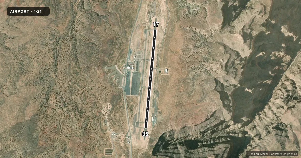
Airport sketch
Runways drawn to scale from FAA survey coordinates, rendered over satellite imagery. Not for navigation.
Approaches & charts
Services on the field
Fuel grades, oxygen, maintenance, ramp storage and lighting — as declared to the FAA by the airport operator.
Fuel & services
- Fuel
- Not available
Ramp & ground
- Transient storage
- Tie-down
- Landing fee
- No fee published
- Lighting schedule
- SEE RMK
- Beacon schedule
- SS-SR
- Beacon
- White / Green (civil land)(WG)
- Wind indicator
- Yes
- Segmented circle
- Yes
Fuel & FBOs
Cheapest 100LL and Jet A on the field and nearby. Always confirm with the FBO before taxi.
Airport notes
Surface conditions, obstructions, local procedures, lighting outages and other notes published with each FAA cycle.
General notes
- ATTN: DUE TO PROXIMITY OF GRAND CANYON NATIONAL PARK SEE SFAR 50-2; PARTICULAR ATTN TO REG FOR OPS BLW 14500 FT MSL.
- PRACTICE TGL NA.
- CTN: HIGH SPEED FIXED WING & ROTARY WING TFC IN & INVOF ARPT.
- TSNT PRKG S END OF APRON.
- FOR CD CTC LOS ANGELES ARTCC AT 661-265-8205.
Lighting notes
- ACTVT REIL RWY 17 & 35; MIRL RWY 17/35 - CTAF.
Runway surface & condition
- 17/35PCR VALUE: 34/F/A/X/T
- 17/35RWY 17 CALM WIND RWY.
Other notes
- PRVDD OPNS CONDUCTED DURING VFR CONDITIONS; SPONSOR ENSURE ALL OPNS ADHERE TO THE COMMUNICATIONS & COORDINATION REQUIREMENTS FOR VFR TFC OPERATING WITHIN & BTN THE BOUNDARIES OF CLASS E AND CLASS B AIRSPACE.
VFR map & nearby airports
VFR sectional. Tap any ICAO chip to open that airport.
Key facts · 1G4
Answer card- ICAO
- 1G4
- Name
- GRAND CANYON WEST
- Location
- PEACH SPRINGS, ARIZONA
- Elevation
- 4,816.7 ft MSL
- Traffic pattern altitude
- 5,816.7 ft MSL (1,000 AGL)
- Control tower
- Non-towered (use CTAF)
- Total runways
- 1
- Longest runway
- 17/35 · 5,000 ft
- Published ILS approaches
- 0
- Published frequencies
- 1
- Magnetic variation
- 14°
- Current flight rules
- VFR
- Current wind
- 110° at 5 kt
- Favored runway now
- RWY 17
Grand Canyon West (1G4) sits near Peach Springs, Arizona, close to Grand Canyon National Park. Field elevation is 4,816.7 ft MSL. The airport has one runway. Runway 17/35 is 5,000 ft asphalt, which is the longest runway on the field. There is no control tower. CTAF is 122.9.
No ILS approaches are published here. Pattern altitude is not published, so use standard 1,000 ft AGL unless current published guidance says otherwise. That puts the light piston pattern at about 5,816.7 ft MSL. Runway 17 is the calm wind runway. Medium intensity runway lights are available on 17/35. Runway end identifier lights are also installed.
This is a high-elevation field with busy mixed traffic. Expect density altitude to matter on warm days. The published remarks also call out special federal rules near Grand Canyon National Park. Review those before you go. Practice touch-and-go landings are not authorized. Transient parking is not authorized at the south end of the apron. For clearance delivery, contact Los Angeles ARTCC at 661-265-8205. No on-field FBOs are listed, so verify fuel and ramp support with the airport operator or call the field directly before arrival.