METAR & TAF 1Z1
1Z1 does not publish a METAR.
Showing the nearest reporting station: KAZC (COLORADO CITY MUNI) · 43.5 NM away. Conditions at 1Z1 may differ.
METAR · KAZC
Observed 12:35Z
KAZC 271235Z AUTO 11009KT 10SM CLR 18/12 A3018 RMK AO2
- Wind
- 110° @ 9 kt
- Visibility
- 10 SM
- Temp / Dew
- 18°C / 12°C
- Altimeter
- 30.18 inHg
- Clouds
- CLR
- Density alt
- 5,122 ft
- Ceiling
- Unlimited
- Rules
- VFR
Airport info & contacts
Manager on record, flight service, ARTCC, attendance schedule and pattern altitude — published by the FAA and refreshed every 28 days.
Location
- From city
- 60 NM SE
- VFR sectional
- LAS VEGAS
- ARTCC
- ZLA · LOS ANGELES
- NOTAM facility
- PRC (NOTAM-D)
Airport manager
- Name
- GAVIN HEATON
- Phone
- 435-628-4010
- Address
- PO BOX 910088, ST GEORGE UT 84791
Flight service · Hours
- FSS PRC
- PRESCOTT1-800-WX-BRIEF
- Attendance
- MAY-OCT · DALGT
- NOV-APR · Unattended
Frequencies
Tap any row to copy the frequency to your clipboard.
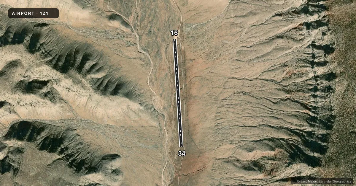
Runways & pattern
Full pagePattern entry · RWY 16
LEFT TRAFFICRunway end performance
| End | TORA | TODA | ASDA | LDA | VGSI | Approach lights | Obstruction |
|---|---|---|---|---|---|---|---|
| 16 | — | — | — | — | — | — | 500', hill, 5000' from thr, 500' R of cntrln, slope 10 |
Declared distances in feet. TORA = takeoff run available, TODA = takeoff distance, ASDA = accelerate-stop, LDA = landing distance.
Airport sketch
Runways drawn to scale from FAA survey coordinates, rendered over satellite imagery. Not for navigation.
Approaches & charts
Services on the field
Fuel grades, oxygen, maintenance, ramp storage and lighting — as declared to the FAA by the airport operator.
Fuel & services
- Fuel
- Not available
Ramp & ground
- Transient storage
- Not published
- Landing fee
- Yes
- Wind indicator
- Yes
- Segmented circle
- No
Fuel & FBOs
Cheapest 100LL and Jet A on the field and nearby. Always confirm with the FBO before taxi.
Airport notes
Surface conditions, obstructions, local procedures, lighting outages and other notes published with each FAA cycle.
General notes
- LIVESTOCK ON RWY.
- FOR CD CTC LOS ANGELES ARTCC AT 661-575-2079.
- WX OBS - 119.42 CANYON WEST.
- CTN: TURB NEAR CANYON RIMS.
- ARPT & SVC INFO - AMGR
Runway surface & condition
- 16/34+3 FT DITCH & BERM 30-35 FT FM CNTRLN BOTH SIDES. PRKG & TURN AROUND NEAR N END OF RWY. 1 PERCENT UPSLOPE TO N.
- 16/344000 FT BY 33 FT ASPH CHIP SEAL RWY 16 END; REMAINDER DIRT.
Approach & departure obstructions
- 16+2 FT BERM 25 FT FM THR BOTH SIDES. PREFERRED FOR TKOF.
- 34PREFERRED FOR LNDG.
Other notes
- VFR USE ONLY.
- WINDSOCK ONLY
VFR map & nearby airports
VFR sectional. Tap any ICAO chip to open that airport.
Key facts · 1Z1
Answer card- ICAO
- 1Z1
- Name
- GRAND CANYON BAR TEN AIRSTRIP
- Location
- WHITMORE, ARIZONA
- Elevation
- 4,100 ft MSL
- Traffic pattern altitude
- 5,100 ft MSL (1,000 AGL)
- Control tower
- Non-towered (use CTAF)
- Total runways
- 1
- Longest runway
- 16/34 · 4,600 ft
- Published ILS approaches
- 0
- Published frequencies
- 1
- Magnetic variation
- 14°
- Current flight rules
- VFR
- Current wind
- 110° at 9 kt
- Favored runway now
- RWY 16
Grand Canyon Bar Ten Airstrip sits near Whitmore, Arizona. The field elevation is 4,100 ft MSL. It has one runway, 16/34, which is 4,600 ft long. There is no control tower. CTAF is 122.9. No ILS approaches are published, so plan this as a VFR field only. The published pattern altitude is not given, so use the current Chart Supplement before you go. For this airport, the remarks matter. Windsock is the only wind indicator. Runway 16 is preferred for takeoff. Runway 34 is preferred for landing. There is a berm close to the threshold on runway 16. There is also a ditch and berm near both sides of the runway centerline, plus a slight upslope to the north. Parking and turnaround are near the north end. Livestock may be on the runway. The airport sits in canyon country, so expect turbulence near the rims and plan for density altitude effects at 4,100 ft MSL. Airport and service information is available from the airport manager. For clearance delivery, contact Los Angeles ARTCC at 661-575-2079.