METAR & TAF KAZC
Current METAR
Observed 11:55Z
KAZC 271155Z AUTO 11008KT 10SM CLR 19/12 A3018 RMK AO2
- Wind
- 110° @ 8 kt
- Visibility
- 10 SM
- Temp / Dew
- 19°C / 12°C
- Altimeter
- 30.18 inHg
- Clouds
- CLR
- Density alt
- 6,201 ft
- Ceiling
- Unlimited
- Rules
- VFR
Airport info & contacts
Manager on record, flight service, ARTCC, attendance schedule and pattern altitude — published by the FAA and refreshed every 28 days.
Location
- From city
- 3 NM SW
- VFR sectional
- LAS VEGAS
- Pattern altitude
- 848 ft AGL · 5,722 ft MSL
- ARTCC
- ZLA · LOS ANGELES
- NOTAM facility
- PRC (NOTAM-D)
Airport manager
- Name
- LADELL BISTLINE SR.
- Phone
- 702-578-3348
- Address
- BOX 99, 1599 W. AIRPORT AVE., COLORADO CITY AZ 86021
Flight service · Hours
- FSS PRC
- PRESCOTT1-800-WX-BRIEF
- Attendance
- MON-SAT · 0800-1800
Frequencies
Tap any row to copy the frequency to your clipboard.
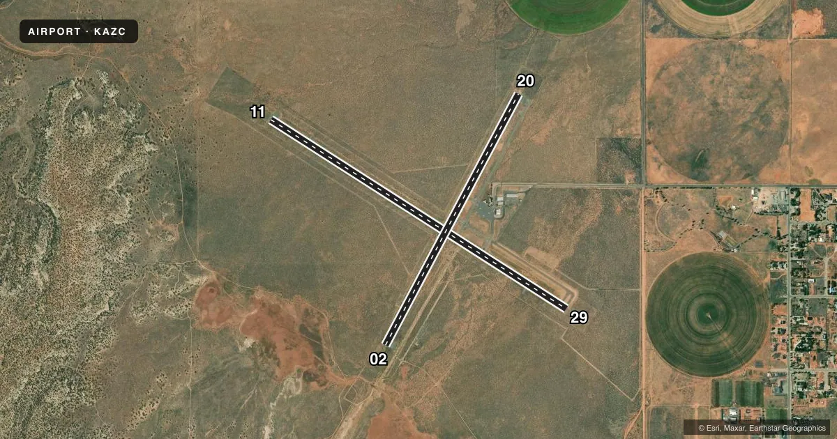
Runways & pattern
Full pagePattern entry · RWY 11
RIGHT TRAFFIC| Runway | Heading (°M) | Length | Surface | Traffic |
|---|---|---|---|---|
| 11/29Favored | 110° / 290° | 6,300 ft | ASPH | 11 R |
| 02/20 | 15° / 195° | 5,099 ft | ASPH | Standard L |
Runway end performance
| End | TORA | TODA | ASDA | LDA | VGSI | Approach lights | Obstruction |
|---|---|---|---|---|---|---|---|
| 11 | — | — | — | — | PAPI 4-box left(3°) | — | — |
| 29 | — | — | — | — | PAPI 4-box left(3°) | — | — |
| 02 | — | — | — | — | PAPI 4-box left(3°) | — | — |
Declared distances in feet. TORA = takeoff run available, TODA = takeoff distance, ASDA = accelerate-stop, LDA = landing distance.
Airport sketch
Runways drawn to scale from FAA survey coordinates, rendered over satellite imagery. Not for navigation.
Approaches & charts
Services on the field
Fuel grades, oxygen, maintenance, ramp storage and lighting — as declared to the FAA by the airport operator.
Fuel & services
- Fuel
- 100LLA+
- Oxygen (bottled)
- High pressure
- Oxygen (bulk)
- HIGH/LOW
- Airframe repair
- Major
- Power plant repair
- Major
- Other services
- INSTR
Ramp & ground
- Transient storage
- Tie-down
- Hangar
- Landing fee
- No fee published
- Lighting schedule
- SEE RMK
- Beacon schedule
- SS-SR
- Beacon
- White / Green (civil land)(WG)
- Wind indicator
- Lighted
- Segmented circle
- Yes
Fuel & FBOs
Cheapest 100LL and Jet A on the field and nearby. Always confirm with the FBO before taxi.
Airport notes
Surface conditions, obstructions, local procedures, lighting outages and other notes published with each FAA cycle.
General notes
- 2000 FT MT N & NE OF ARPT.
- 3 FT BRUSH WI PRIM SFC OF RWYS.
- WILDLIFE ON & INVOF ARPT.
- TWY B & RWY 02 TURN AROUND RETRO REFLECTOR MRKS.
- FOR CD CTC LOS ANGELES ARTCC AT 661-575-2079.
- SELF SVC FUEL AVBL.
Lighting notes
- ACTVT REIL RWY 11; PAPI RWY 02 & 11; MIRL RWY 02/20 & 11/29 - CTAF.
Other notes
- CALL - AMGR.
- CALL - AMGR.
- CALL - AMGR.
VFR map & nearby airports
VFR sectional. Tap any ICAO chip to open that airport.
Key facts · KAZC
Answer card- ICAO
- KAZC
- Name
- COLORADO CITY MUNI
- Location
- COLORADO CITY, ARIZONA
- Elevation
- 4,873.8 ft MSL
- Traffic pattern altitude
- 5,721.8 ft MSL (848 AGL)
- Control tower
- Non-towered (use CTAF)
- Total runways
- 2
- Longest runway
- 11/29 · 6,300 ft
- Published ILS approaches
- 0
- Published frequencies
- 2
- Magnetic variation
- 13°
- Current flight rules
- VFR
- Current wind
- 110° at 8 kt
- Favored runway now
- RWY 11
Colorado City Muni sits in Colorado City, Arizona. The field elevation is 4,873.8 ft MSL. It has two asphalt runways. The longest is 11/29 at 6,300 ft. The airport is non-towered. CTAF and UNICOM are both 122.7.
No ILS approaches are published here. Pattern altitude is 848 ft AGL, which is 5,721.8 ft MSL. That matters here because the field is already high. Expect density altitude to be a real factor on warm days. There is also a 2,000 ft mountain to the north and northeast of the airport. Plan your arrivals and departures with that in mind.
Westwing Aviation is on the field. It carries 100LL, Jet A and Jet A Prist. Self-service fuel is available. The published remarks also note runway lighting on both runways. REIL is on runway 11. PAPI is on runways 02 and 11. Taxiway B and the runway 02 turnaround have retroreflector markings. Wildlife is reported on and near the airport. There is also 3 ft brush within the primary surface of the runways. Call the airport manager before you go. For clearance delivery, contact Los Angeles ARTCC at 661-575-2079.