METAR & TAF U55
Current METAR
Observed 05:35Z
KU55 270535Z AUTO 22006KT 10SM 21/12 A3032 RMK A01
- Wind
- 220° @ 6 kt
- Visibility
- 10 SM
- Temp / Dew
- 21°C / 12°C
- Altimeter
- 30.32 inHg
- Clouds
- Clear
- Density alt
- 8,610 ft
- Ceiling
- Unlimited
- Rules
- VFR
Airport info & contacts
Manager on record, flight service, ARTCC, attendance schedule and pattern altitude — published by the FAA and refreshed every 28 days.
Location
- From city
- 3 NM NE
- VFR sectional
- LAS VEGAS
- ARTCC
- ZLC · SALT LAKE CITY
- NOTAM facility
- CDC (NOTAM-D)
Airport manager
- Name
- MAT HOUSTON
- Phone
- 435-676-8585
- Address
- 25 SOUTH 200 EAST, PO BOX 75, PANGUITCH UT 84759
Flight service · Hours
- FSS CDC
- CEDAR CITY1-800-WX-BRIEF
- Attendance
- Unattended
Frequencies
Tap any row to copy the frequency to your clipboard.
Runways & pattern
Full pagePattern entry · RWY 18
LEFT TRAFFICRunway end performance
| End | TORA | TODA | ASDA | LDA | VGSI | Approach lights | Obstruction |
|---|---|---|---|---|---|---|---|
| 18 | — | — | — | — | PAPI 2-box left(3°) | — | — |
| 36 | — | — | — | — | PAPI 2-box left(3°) | — | — |
Declared distances in feet. TORA = takeoff run available, TODA = takeoff distance, ASDA = accelerate-stop, LDA = landing distance.
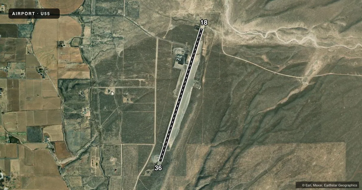
Airport sketch
Runways drawn to scale from FAA survey coordinates, rendered over satellite imagery. Not for navigation.
Approaches & charts
Services on the field
Fuel grades, oxygen, maintenance, ramp storage and lighting — as declared to the FAA by the airport operator.
Fuel & services
- Fuel
- Not available
- Oxygen (bottled)
- Not available
- Oxygen (bulk)
- Not available
Ramp & ground
- Transient storage
- Tie-down
- Landing fee
- No fee published
- Customs
- Not available
- Lighting schedule
- SEE RMK
- Beacon schedule
- SS-SR
- Beacon
- White / Green (civil land)(WG)
- Wind indicator
- Lighted
- Segmented circle
- Yes
Fuel & FBOs
Cheapest 100LL and Jet A on the field and nearby. Always confirm with the FBO before taxi.
Airport notes
Surface conditions, obstructions, local procedures, lighting outages and other notes published with each FAA cycle.
General notes
- COLD TEMPERATURE AIRPORT. ALTITUDE CORRECTION REQUIRED AT OR BELOW -27C.
- FOR CD CTC SALT LAKE ARTCC AT 801-320-2568.
- NO FUEL
- NO COURTESY CAR AVBL.
Lighting notes
- ACTVT REIL RWY 18/36; PAPI RWY 18/36; MIRL RWY 18/36 - CTAF.
Other notes
- MANAGERCITY/AMGR.
VFR map & nearby airports
VFR sectional. Tap any ICAO chip to open that airport.
Key facts · U55
Answer card- ICAO
- U55
- Name
- PANGUITCH MUNI
- Location
- PANGUITCH, UTAH
- Elevation
- 6,762.5 ft MSL
- Traffic pattern altitude
- 7,762.5 ft MSL (1,000 AGL)
- Control tower
- Non-towered (use CTAF)
- Total runways
- 1
- Longest runway
- 18/36 · 5,700 ft
- Published ILS approaches
- 0
- Published frequencies
- 1
- Magnetic variation
- 12°
- Current flight rules
- VFR
- Current wind
- 220° at 6 kt
- Favored runway now
- RWY 18
Panguitch Muni is in Panguitch, Utah. The field elevation is 6,762.5 ft MSL. It has one runway, 18/36, which is 5,700 ft long. There is no control tower. CTAF is 122.9. No ILS approaches are published.
Pattern altitude is not published. Use the standard 1,000 ft AGL pattern for light piston operations unless the current Chart Supplement says otherwise. The runway lighting setup includes runway end identifier lights, PAPI and medium intensity runway lights on 18/36. Use CTAF to activate the lights.
There are no on-field FBOs listed. No fuel is available here. No courtesy car is available. The airport manager is the city manager. For clearance delivery, contact Salt Lake ARTCC at 801-320-2568. This is a cold temperature airport, so altitude correction is required at or below minus 27 degrees Celsius. At this elevation, performance planning matters. Expect high-density-altitude effects in warm weather. Verify takeoff and landing distances before you go.